FAA INFORMATION EFFECTIVE 30 OCTOBER 2025
Location
| FAA Identifier: | FDW |
| Lat/Long: | 34-18-56.6000N 081-06-30.8000W
34-18.943333N 081-06.513333W
34.3157222,-81.1085556
(estimated) |
| Elevation: | 577.5 ft. / 176.0 m (surveyed) |
| Variation: | 07W (2015) |
| From city: | 3 miles SW of WINNSBORO, SC |
| Time zone: | UTC -5 (UTC -4 during Daylight Saving Time) |
| Zip code: | 29180 |
Airport Operations
| Airport use: | Open to the public |
| Activation date: | 06/1975 |
| Control tower: | no |
| ARTCC: | JACKSONVILLE CENTER |
| FSS: | ANDERSON FLIGHT SERVICE STATION |
| NOTAMs facility: | AND (NOTAM-D service available) |
| Attendance: | MAR-OCT 0800-1800, NOV-FEB 0800-1700 |
| Pattern altitude: | 1399.5 ft. MSL |
| Wind indicator: | lighted |
| Segmented circle: | yes |
| Lights: | ACTVT MIRL RY 04/22 & PAPI RYS 04 & 22 - CTAF. |
| Beacon: | white-green (lighted land airport)
Operates sunset to sunrise. |
Airport Communications
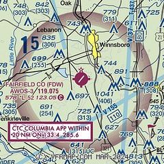
| CTAF/UNICOM: | 123.05 |
| WX AWOS-3: | 119.075 (803-712-2577) |
| COLUMBIA APPROACH: | 133.4 [OPR 1100-0300Z++ MON-FRI, 1300-2100Z++ SAT-SUN, CLSD FED HOL, AND ACC FAMILY DAYS.] |
| COLUMBIA DEPARTURE: | 133.4 [OPR 1100-0300Z++ MON-FRI, 1300-2100Z++ SAT-SUN, CLSD FED HOL, AND ACC FAMILY DAYS.] |
Nearby radio navigation aids
| VOR radial/distance | | VOR name | | Freq | | Var |
|---|
| CAEr356/27.6 | | COLUMBIA VORTAC | | 114.70 | | 02W |
| MMTr335/28.0 | | MC ENTIRE VORTAC | | 113.20 | | 08W |
| NDB name | | Hdg/Dist | | Freq | | Var | | ID |
|---|
| ENOREE | | 096/26.2 | | 278 | | 07W | | EOE | . --- . |
| CHESTER | | 177/28.6 | | 220 | | 06W | | DCM | -.. -.-. -- |
| UNION COUNTY | | 136/34.4 | | 326 | | 06W | | UOT | ..- --- - |
Airport Services
| Fuel available: | 100LL JET-A |
| Parking: | tiedowns |
| Airframe service: | MAJOR |
| Powerplant service: | MAJOR |
| Bottled oxygen: | NONE |
| Bulk oxygen: | NONE |
Runway Information
Runway 4/22
| Dimensions: | 5243 x 100 ft. / 1598 x 30 m |
| Surface: | asphalt, in excellent condition |
| Weight bearing capacity: | | Single wheel: | 42.0 | | Double wheel: | 60.0 |
|
| Runway edge lights: | medium intensity |
| RUNWAY 4 | | RUNWAY 22 |
| Latitude: | 34-18.603628N | | 34-19.282427N |
| Longitude: | 081-06.835912W | | 081-06.191048W |
| Elevation: | 577.5 ft. | | 559.1 ft. |
| Traffic pattern: | left | | left |
| Runway heading: | 045 magnetic, 038 true | | 225 magnetic, 218 true |
| Displaced threshold: | 233 ft. | | no |
| Markings: | nonprecision, in good condition | | nonprecision, in good condition |
| Visual slope indicator: | 4-light PAPI on left (3.00 degrees glide path) | | 4-light PAPI on left (3.00 degrees glide path) |
| Touchdown point: | yes, no lights | | yes, no lights |
| Obstructions: | 19 ft. tree, 479 ft. from runway, 166 ft. right of centerline, 14:1 slope to clear | | 80 ft. tree, 2820 ft. from runway, 297 ft. right of centerline, 32:1 slope to clear |
Airport Ownership and Management from official FAA records
| Ownership: | Publicly-owned |
| Owner: | FAIRFIELD COUNTY
PO BOX 216
WINNSBORO, SC 29180
Phone (803) 635-1058 |
| Manager: | DENISE BRYAN
1291 RUNWAY RD
WINNSBORO, SC 29180
Phone (803) 718-0087 |
Additional Remarks
| - | TPA 1400 MSL. |
| - | FOR CD CTC COLUMBIA APCH AT 803-822-5242 OR 803-822-5040. |
| - | (CONTACT TITLE) FOR FBO CALL (803) 635-3086. |
Instrument Procedures
NOTE: All procedures below are presented as PDF files. If you need a reader for these files, you should download the free Adobe Reader.NOT FOR NAVIGATION. Please procure official charts for flight.
FAA instrument procedures published for use from 30 October 2025 at 0901Z to 27 November 2025 at 0900Z.
IAPs - Instrument Approach Procedures |
|---|
| RNAV (GPS) RWY 04 | |
download (213KB) |
| RNAV (GPS) RWY 22 | |
download (206KB) |
| NOTE: Special Alternate Minimums apply | |
download (51KB) |
| NOTE: Special Take-Off Minimums/Departure Procedures apply | |
download (273KB) |
Other nearby airports with instrument procedures:
KCUB - Jim Hamilton L B Owens Airport (21 nm S)
KCAE - Columbia Metro Airport (23 nm S)
KEOE - Newberry County Airport (26 nm W)
KCDN - Woodward Field Airport (27 nm E)
KLKR - Lancaster County Airport-Mc Whirter Field (27 nm NE)
|
|

Road maps at:
MapQuest
Bing
Google
| Aerial photo |
|---|
WARNING: Photo may not be current or correct

Do you have a better or more recent aerial photo of Fairfield County Airport that you would like to share? If so, please send us your photo.
|
| Sectional chart |
|---|
|
| Airport distance calculator |
|---|
|
|
| Sunrise and sunset |
|---|
|
Times for 22-Nov-2025
| | Local
(UTC-5) | | Zulu
(UTC) |
|---|
| Morning civil twilight | | 06:38 | | 11:38 |
| Sunrise | | 07:05 | | 12:05 |
| Sunset | | 17:16 | | 22:16 |
| Evening civil twilight | | 17:43 | | 22:43 |
|
| Current date and time |
|---|
| Zulu (UTC) | 22-Nov-2025 21:17:16 |
|---|
| Local (UTC-5) | 22-Nov-2025 16:17:16 |
|---|
|
| METAR |
|---|
| KFDW | 222055Z AUTO 25005KT 10SM CLR 25/16 A2990 RMK AO1
|
|
| TAF |
|---|
KCUB
22nm S | 221913Z 2219/2318 26013G20KT P6SM SCT035 SCT080 FM222200 27007KT P6SM SCT035 SCT080 FM230200 VRB03KT P6SM SCT040 FM231400 05005KT P6SM SCT250
|
KCAE
23nm S | 221913Z 2219/2318 26013G20KT P6SM SCT035 BKN080 FM222200 27008KT P6SM SCT035 SCT080 FM230500 VRB03KT P6SM SCT040 FM231400 05005KT P6SM SCT250
|
|
| NOTAMs |
|---|
NOTAMs are issued by the DoD/FAA and will open in a separate window not controlled by AirNav.
|
|

