FAA INFORMATION EFFECTIVE 27 NOVEMBER 2025
Location
| FAA Identifier: | LNC |
| Lat/Long: | 32-34-39.3750N 096-43-03.0100W
32-34.656250N 096-43.050167W
32.5776042,-96.7175028
(estimated) |
| Elevation: | 501.1 ft. / 152.7 m (surveyed) |
| Variation: | 06E (1990) |
| From city: | 2 miles S of LANCASTER, TX |
| Time zone: | UTC -6 (UTC -5 during Daylight Saving Time) |
| Zip code: | 75146 |
Airport Operations
| Airport use: | Open to the public |
| Activation date: | 08/1968 |
| Control tower: | no |
| ARTCC: | FORT WORTH CENTER |
| FSS: | FORT WORTH FLIGHT SERVICE STATION |
| NOTAMs facility: | LNC (NOTAM-D service available) |
| Attendance: | FRI-SUN 0700-1900, ALL MON-THUR 0700-1800
ARPT UNATNDD THANKSGIVING, CHRISTMAS EVE 1800Z THRU CHRISTMAS. |
| Wind indicator: | lighted |
| Segmented circle: | yes |
| Lights: | ACTVT MIRL RWY 13/31 - CTAF. |
| Beacon: | white-green (lighted land airport)
Operates sunset to sunrise. |
Airport Communications
| CTAF/UNICOM: | 122.7 |
| WX AWOS-3PT: | 118.975 (972-227-0471) |
| LONE STAR APPROACH: | 125.2 [1345-0600Z++ MON-THU; 1345-2345Z++ FRI; CLSD SAT, SUN AND HOL EXC BY NOTAM, HRS SUBJ TO CHG.] |
| LONE STAR DEPARTURE: | 125.2 [1345-0600Z++ MON-THU; 1345-2345Z++ FRI; CLSD SAT, SUN AND HOL EXC BY NOTAM, HRS SUBJ TO CHG.] |
| BOTCH DP: | 125.2 |
| DALLAS AREA DP: | 125.2 |
| DODJE STAR: | 125.2 125.9 |
| FINGR STAR: | 124.3 125.275 |
| GARLAND DP: | 125.2 |
| GREGS STAR: | 118.1 |
| JFRYE STAR: | 118.1 |
| JOE POOL DP: | 125.2 |
| NANDR RNAV DP: | 125.2 |
| REEKO STAR: | 125.2 |
| SLANT STAR: | 125.275 |
| SWVAY STAR: | 135.975 |
| YEAGR STAR: | 125.025 125.275 |
| WX ASOS at RBD (10 nm NW): | PHONE 214-330-5317 |
| WX AWOS-3P at JWY (12 nm SW): | 119.575 (972-227-0471) |
| WX AWOS-3 at 49T (12 nm N): | 135.425 (214-670-1243) |
| WX AWOS-3 at HQZ (14 nm NE): | 118.175 (972-222-7631) |
| WX ASOS at DAL (17 nm NW): | PHONE 214-353-1551 |
| WX AWOS-3P at GPM (18 nm NW): | 118.475 (972-606-1433) |
| WX ASOS at GKY (20 nm W): | 127.375 (817-557-0251) |
Nearby radio navigation aids
| VOR radial/distance | | VOR name | | Freq | | Var |
|---|
| CVEr147/21.0 | | COWBOY VOR/DME | | 116.20 | | 06E |
| TTTr131/23.9 | | MAVERICK VOR/DME | | 113.10 | | 06E |
| FUZr123/29.9 | | RANGER VORTAC | | 115.70 | | 06E |
| CQYr307/34.5 | | CEDAR CREEK VORTAC | | 114.80 | | 06E |
Airport Services
| Fuel available: | 100LL JET-A+ |
| Parking: | tiedowns |
| Airframe service: | MAJOR |
| Powerplant service: | MAJOR |
| Bottled oxygen: | NONE |
| Bulk oxygen: | NONE |
Runway Information
Runway 13/31
| Dimensions: | 6500 x 100 ft. / 1981 x 30 m |
| Surface: | asphalt, in excellent condition |
| Weight bearing capacity: | | Single wheel: | 20.0 | | Double wheel: | 60.0 |
|
| Runway edge lights: | medium intensity |
| RUNWAY 13 | | RUNWAY 31 |
| Latitude: | 32-35.068833N | | 32-34.244000N |
| Longitude: | 096-43.454500W | | 096-42.646000W |
| Elevation: | 501.1 ft. | | 475.3 ft. |
| Traffic pattern: | left | | right |
| Runway heading: | 134 magnetic, 140 true | | 314 magnetic, 320 true |
| Markings: | precision, in good condition | | precision, in good condition |
| Visual slope indicator: | 4-light PAPI on left (3.00 degrees glide path) | | 4-light PAPI on left (3.00 degrees glide path) |
| Runway end identifier lights: | no | | no |
| Touchdown point: | yes, no lights | | yes, no lights |
| Obstructions: | none | | 18 ft. trees, 340 ft. from runway, 333 ft. left of centerline, 7:1 slope to clear |
Airport Ownership and Management from official FAA records
| Ownership: | Publicly-owned |
| Owner: | CITY OF LANCASTER
211 N HENRY STREET, PO BOX 940
LANCASTER, TX 75146
Phone 972-218-1300 |
| Manager: | KELLEN BENBROOK
950 FERRIS ROAD
LANCASTER, TX 75146
Phone 972-227-5721
ARPT ADMIN: 972-218-1273. |
Additional Remarks
| - | FULL ON AUTO-ROTATIONS, SLIDING SKID LDG OR TKOFS BY SKID TYPE HELS ON ANY PAVED SFC NOT AUTH. |
| - | WILDLIFE ON & INVOF ARPT. |
| - | N RAMP HEL PRKG CIRCLES ROTARY WING USE ONLY, APCH AND DEP NA. |
| - | FOR CD CTC REGIONAL APCH AT 972-615-2799. |
Instrument Procedures
NOTE: All procedures below are presented as PDF files. If you need a reader for these files, you should download the free Adobe Reader.NOT FOR NAVIGATION. Please procure official charts for flight.
FAA instrument procedures published for use from 27 November 2025 at 0901Z to 25 December 2025 at 0900Z.
STARs - Standard Terminal Arrivals |
|---|
| DODJE SIX **CHANGED** | |
2 pages:
[1] [2] (673KB) |
| FINGR ONE **NEW** | |
2 pages:
[1] [2] (428KB) |
| GREGS ONE **CHANGED** | |
2 pages:
[1] [2] (469KB) |
| HERBZ TWO (RNAV) **CHANGED** | |
download (281KB) |
| JFRYE FIVE (RNAV) **CHANGED** | |
download (257KB) |
| REEKO THREE (RNAV) **CHANGED** | |
download (214KB) |
| SLANT THREE (RNAV) | |
download (253KB) |
| SWVAY FOUR (RNAV) | |
download (238KB) |
| WESAT THREE (RNAV) **NEW** | |
download (209KB) |
IAPs - Instrument Approach Procedures |
|---|
| RNAV (GPS) RWY 31 | |
download (230KB) |
| NOTE: Special Alternate Minimums apply | |
download (117KB) |
Departure Procedures |
|---|
| BOTCH ONE (RNAV) | |
2 pages:
[1] [2] (364KB) |
| DALLAS FOUR **NEW** | |
2 pages:
[1] [2] (340KB) |
| GARLAND SIX | |
2 pages:
[1] [2] (337KB) |
| JOE POOL EIGHT | |
2 pages:
[1] [2] (458KB) |
| KINGDOM FIVE | |
2 pages:
[1] [2] (363KB) |
| KUSSO ONE (RNAV) | |
2 pages:
[1] [2] (333KB) |
| NANDR THREE (RNAV) | |
2 pages:
[1] [2] (329KB) |
| TEXOMA FIVE | |
2 pages:
[1] [2] (448KB) |
| WORTH ONE | |
2 pages:
[1] [2] (428KB) |
| NOTE: Special Take-Off Minimums/Departure Procedures apply | |
download (305KB) |
Other nearby airports with instrument procedures:
KRBD - Dallas Executive Airport (10 nm NW)
KJWY - Mid-Way Regional Airport (12 nm SW)
KHQZ - Mesquite Metro Airport (14 nm NE)
F41 - Ennis Municipal Airport (15 nm S)
KDAL - Dallas Love Field Airport (17 nm NW)
KGPM - Grand Prairie Municipal Airport (18 nm NW)
KGKY - Arlington Municipal Airport (20 nm W)
|
|

Road maps at:
MapQuest
Bing
Google
| Aerial photo |
|---|
WARNING: Photo may not be current or correct
 Taken in November 2015
looking east.
Taken in November 2015
looking east.
Do you have a better or more recent aerial photo of Lancaster Regional Airport that you would like to share? If so, please send us your photo.
|
| Sectional chart |
|---|
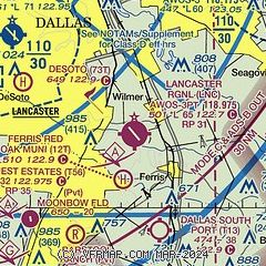
|
CAUTION: Diagram may not be current

| Airport distance calculator |
|---|
|
|
| Sunrise and sunset |
|---|
|
Times for 12-Dec-2025
| | Local
(UTC-6) | | Zulu
(UTC) |
|---|
| Morning civil twilight | | 06:53 | | 12:53 |
| Sunrise | | 07:20 | | 13:20 |
| Sunset | | 17:21 | | 23:21 |
| Evening civil twilight | | 17:48 | | 23:48 |
|
| Current date and time |
|---|
| Zulu (UTC) | 12-Dec-2025 09:11:41 |
|---|
| Local (UTC-6) | 12-Dec-2025 03:11:41 |
|---|
|
| METAR |
|---|
| KLNC | 120855Z AUTO 00000KT 10SM CLR 06/00 A2992 RMK AO2 T00620001
|
KRBD
10nm NW | 120853Z AUTO 15005KT 10SM CLR 07/01 A2989 RMK AO2 SLP118 T00720006 56004
|
KJWY
12nm SW | 120855Z AUTO 15005KT 10SM CLR 07/01 A2991 RMK AO2 T00740011 56006 $
|
KHQZ
14nm NE | 120855Z AUTO 16005KT 10SM CLR 07/01 A2991 RMK AO1 T00650009
|
KDAL
18nm N | 120853Z 12005KT 10SM FEW250 11/01 A2990 RMK AO2 SLP120 T01060006 56002
|
KGPM
18nm NW | 120855Z AUTO 20006KT 10SM CLR 11/00 A2991 RMK AO2 T01050003
|
|
| TAF |
|---|
KDAL
18nm N | 120535Z 1206/1306 17008KT P6SM FEW250 FM121700 01008KT P6SM FEW250
|
KGKY
20nm W | 120535Z 1206/1306 17008KT P6SM FEW250 FM121700 01008KT P6SM FEW250
|
|
| NOTAMs |
|---|
NOTAMs are issued by the DoD/FAA and will open in a separate window not controlled by AirNav.
|
|


