FAA INFORMATION EFFECTIVE 19 FEBRUARY 2026
Location
| FAA Identifier: | LWA |
| Lat/Long: | 42-21-04.7750N 086-15-20.6550W
42-21.079583N 086-15.344250W
42.3513264,-86.2557375
(estimated) |
| Elevation: | 665.5 ft. / 202.8 m (surveyed) |
| Variation: | 03W (1985) |
| From city: | 3 miles S of SOUTH HAVEN, MI |
| Time zone: | UTC -5 (UTC -4 during Daylight Saving Time) |
| Zip code: | 49090 |
Airport Operations
| Airport use: | Open to the public |
| Activation date: | 10/1944 |
| Control tower: | no |
| ARTCC: | CHICAGO CENTER |
| FSS: | LANSING FLIGHT SERVICE STATION |
| NOTAMs facility: | LWA (NOTAM-D service available) |
| Attendance: | 0900-1700 |
| Wind indicator: | lighted |
| Segmented circle: | yes |
| Lights: | ACTVT OR INCR INTST REIL RWY 05 & 23; MIRL RWY 05/23 - CTAF. PAPI RWY 05 & 23 OPR CONSLY; MIRL RWY 05/23 PRESET LOW INTST DUSK-2300. |
| Beacon: | white-green (lighted land airport)
Operates sunset to sunrise. |
Airport Communications
| CTAF/UNICOM: | 122.8 |
| WX AWOS-3P: | 118.025 (269-637-7016) |
| SOUTH BEND APPROACH: | 118.55 |
| SOUTH BEND DEPARTURE: | 118.55 |
| WX ASOS at BEH (15 nm SW): | 121.55 (269-925-9008) |
- APCH/DEP SVC PRVDD BY CHICAGO ARTCC ON FREQS 128.5/273.525 (PULLMAN RCAG) WHEN SBN TWR CLSD.
Nearby radio navigation aids
| VOR radial/distance | | VOR name | | Freq | | Var |
|---|
| PMMr224/9.6 | | PULLMAN VOR/DME | | 112.10 | | 00E |
| GIJr005/35.1 | | GIPPER VORTAC | | 115.40 | | 00E |
Airport Services
| Fuel available: | 100LL JET-A+ |
| Parking: | hangars and tiedowns |
| Airframe service: | MAJOR |
| Powerplant service: | MAJOR |
| Bottled oxygen: | NONE |
| Bulk oxygen: | NONE |
Runway Information
Runway 5/23
| Dimensions: | 4800 x 75 ft. / 1463 x 23 m |
| Surface: | asphalt, in good condition |
| Weight bearing capacity: | |
| Runway edge lights: | medium intensity |
| RUNWAY 5 | | RUNWAY 23 |
| Latitude: | 42-20.871015N | | 42-21.441415N |
| Longitude: | 086-15.602795W | | 086-14.865373W |
| Elevation: | 651.8 ft. | | 665.4 ft. |
| Traffic pattern: | left | | left |
| Runway heading: | 047 magnetic, 044 true | | 227 magnetic, 224 true |
| Markings: | nonprecision, in good condition | | nonprecision, in good condition |
| Visual slope indicator: | 4-light PAPI on left (3.50 degrees glide path) | | 4-light PAPI on left (3.50 degrees glide path) |
| Runway end identifier lights: | yes | | yes |
| Touchdown point: | yes, no lights | | yes, no lights |
| Obstructions: | 60 ft. tree, 1395 ft. from runway, 280 ft. left of centerline, 19:1 slope to clear | | 22 ft. trees, 505 ft. from runway, 280 ft. right of centerline, 13:1 slope to clear |
Runway 14/32
| Dimensions: | 3260 x 190 ft. / 994 x 58 m |
| Surface: | turf, in fair condition |
| Runway edge markings: | DTHR MKD WITH 3 FT YELLOW CONES, 3 EACH SIDE. |
| RUNWAY 14 | | RUNWAY 32 |
| Latitude: | 42-21.148563N | | 42-20.784840N |
| Longitude: | 086-15.772460W | | 086-15.240443W |
| Elevation: | 648.5 ft. | | 663.5 ft. |
| Traffic pattern: | left | | left |
| Runway heading: | 136 magnetic, 133 true | | 316 magnetic, 313 true |
| Displaced threshold: | 956 ft. | | 1229 ft. |
| Runway end identifier lights: | no | | no |
| Touchdown point: | yes, no lights | | yes, no lights |
| Obstructions: | 78 ft. trees, 10 ft. from runway, 110 ft. left of centerline
APCH RATIO 12:1 TO DTHR OVR 78 FT TREES, 966 FT DIST, 110 FT L. | | 50 ft. tree, 235 ft. from runway, 148 ft. left of centerline, 4:1 slope to clear |
Airport Ownership and Management from official FAA records
| Ownership: | Publicly-owned |
| Owner: | SO HAVEN AREA RGNL ARPT AUTH
73020 COUNTY ROAD 380
SOUTH HAVEN, MI 49090-9441
Phone 269-637-7343 |
| Manager: | JOHN CARLSON
73020 COUNTY ROAD 380
SOUTH HAVEN, MI 49090-9441
Phone 269-637-7343
CELL 269-209-4832. |
Additional Remarks
| - | DEER & LRG BIRDS ON & INVOF ARPT. |
| - | AG OPS SUMMER MONTHS. |
| - | ADMIN BLDG ACES, PRESS V, THEN III & II SIMUL, THEN I. |
| - | FOR FLD CONDS AFT HRS CALL AMGR CELL. |
| - | CK LCL CONDS BFR USE OF TURF RWY 14/32 - CALL AMGR. |
| - | FOR CD CTC SOUTH BEND APCH AT 574-251-2609. WHEN SOUTH BEND APCH CLSD, FOR CD CTC CHICAGO ARTCC AT 630-906-8921. |
Instrument Procedures
NOTE: All procedures below are presented as PDF files. If you need a reader for these files, you should download the free Adobe Reader.NOT FOR NAVIGATION. Please procure official charts for flight.
FAA instrument procedures published for use from 19 February 2026 at 0901Z to 19 March 2026 at 0900Z.
IAPs - Instrument Approach Procedures |
|---|
| RNAV (GPS) RWY 05 | |
download (204KB) |
| RNAV (GPS) RWY 23 | |
download (204KB) |
| NOTE: Special Alternate Minimums apply | |
download (155KB) |
| NOTE: Special Take-Off Minimums/Departure Procedures apply | |
download (349KB) |
Other nearby airports with instrument procedures:
KBEH - Southwest Michigan Regional Airport (15 nm SW)
35D - Padgham Field Airport (22 nm NE)
C91 - Dowagiac Municipal Airport (22 nm S)
KBIV - West Michigan Regional Airport (24 nm N)
C20 - Andrews University Airpark (25 nm S)
|
|

Road maps at:
MapQuest
Bing
Google
| Aerial photo |
|---|
WARNING: Photo may not be current or correct

Do you have a better or more recent aerial photo of South Haven Area Regional Airport that you would like to share? If so, please send us your photo.
|
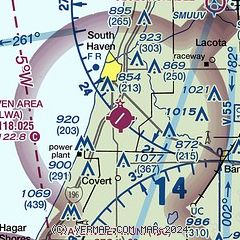
| Sectional chart |
|---|
|
| Airport distance calculator |
|---|
|
|
| Sunrise and sunset |
|---|
|
Times for 01-Mar-2026
| | Local
(UTC-5) | | Zulu
(UTC) |
|---|
| Morning civil twilight | | 06:53 | | 11:53 |
| Sunrise | | 07:21 | | 12:21 |
| Sunset | | 18:33 | | 23:33 |
| Evening civil twilight | | 19:02 | | 00:02 |
|
| Current date and time |
|---|
| Zulu (UTC) | 01-Mar-2026 05:13:45 |
|---|
| Local (UTC-5) | 01-Mar-2026 00:13:45 |
|---|
|
| METAR |
|---|
| KLWA | 010455Z AUTO 03010KT 10SM OVC011 M04/M07 A3028 RMK AO2 400921038
|
KBEH
15nm SW | 010453Z AUTO VRB04KT 10SM OVC013 M03/M06 A3028 RMK AO2 SLP262 T10331061 400891033
|
|
| TAF |
|---|
KAZO
32nm E | 010101Z 0101/0124 01010KT P6SM VCSH SCT013 OVC040 TEMPO 0101/0104 4SM -SN OVC013 FM011300 02005KT P6SM SCT100
|
KSBN
39nm S | 010250Z 0103/0124 02009KT P6SM OVC100 FM011400 04008KT P6SM SCT035 FM011800 03008KT P6SM FEW250
|
|
| NOTAMs |
|---|
NOTAMs are issued by the DoD/FAA and will open in a separate window not controlled by AirNav.
|
|

