FAA INFORMATION EFFECTIVE 14 MAY 2026
Location
| FAA Identifier: | MFE |
| Lat/Long: | 26-10-33.0000N 098-14-19.0000W
26-10.550000N 098-14.316667W
26.1758333,-98.2386111
(estimated) |
| Elevation: | 107.2 ft. / 32.7 m (surveyed) |
| Variation: | 04E (2020) |
| From city: | 2 miles S of MC ALLEN, TX |
| Time zone: | UTC -5 (UTC -6 during Standard Time) |
| Zip code: | 78503 |
Airport Operations
| Airport use: | Open to the public |
| Activation date: | 01/1940 |
| Control tower: | yes |
| ARTCC: | HOUSTON CENTER |
| FSS: | SAN ANGELO FLIGHT SERVICE STATION |
| NOTAMs facility: | MFE (NOTAM-D service available) |
| Attendance: | 0600-0001
FOR SVCS AFT HRS CALL 956-686-1774. |
| Wind indicator: | lighted |
| Segmented circle: | yes |
| Lights: | WHEN ATCT CLSD ACTVT MALSR RWY 14; HIRL RWY 14/32; MIRL RWY 18/36 - CTAF. |
| Beacon: | white-green (lighted land airport)
Operates sunset to sunrise. |
| Fire and rescue: | ARFF index C |
| International operations: | international airport of entry |
Airport Communications
| CTAF: | 118.5 |
| UNICOM: | 122.95 |
| ATIS: | 128.5 |
| WX ASOS: | PHONE 956-664-8212 |
| MC ALLEN GROUND: | 121.8 [0600-0000] |
| MC ALLEN TOWER: | 118.5 256.9 [0600-0000] |
| VALLEY APPROACH: | 126.55 |
| VALLEY DEPARTURE: | 126.55 |
| EMERG: | 121.5 243.0 |
| WX AWOS-3PT at TXW (14 nm E): | 118.575 (956-447-0414) |
| WX AWOS-3PT at EBG (17 nm N): | 118.025 (956-587-0743) |
Nearby radio navigation aids
| VOR radial/distance | | VOR name | | Freq | | Var |
|---|
| MFE at field | | MC ALLEN VOR/DME | | 117.20 | | 09E |
| REXr350/9.9 | | REYNOSA VOR/DME | | 112.40 | | 08E |
| HRLr259/31.7 | | HARLINGEN VOR/DME | | 113.65 | | 05E |
| NDB name | | Hdg/Dist | | Freq | | Var | | ID |
|---|
| MISSI | | 136/6.1 | | 330 | | 04E | | MF | -- ..-. |
Airport Services
| Fuel available: | 100LL JET-A |
| Parking: | hangars and tiedowns |
| Airframe service: | MAJOR |
| Powerplant service: | MAJOR |
| Bottled oxygen: | HIGH |
Runway Information
Runway 14/32
| Dimensions: | 7120 x 150 ft. / 2170 x 46 m |
| Surface: | asphalt/grooved, in good condition |
| Weight bearing capacity: | | Single wheel: | 90.0 | | Double wheel: | 190.0 | | Double tandem: | 280.0 |
|
| Runway edge lights: | high intensity |
| RUNWAY 14 | | RUNWAY 32 |
| Latitude: | 26-10.975718N | | 26-10.067845N |
| Longitude: | 098-14.779693W | | 098-13.952452W |
| Elevation: | 107.2 ft. | | 101.0 ft. |
| Traffic pattern: | left | | left |
| Runway heading: | 137 magnetic, 141 true | | 317 magnetic, 321 true |
| Displaced threshold: | 137 ft. | | no |
| Declared distances: | TORA:7120 TODA:7120 ASDA:7120 LDA:6983 | | TORA:7120 TODA:7120 ASDA:7120 LDA:7120 |
| Markings: | precision, in fair condition | | precision, in fair condition |
| Visual slope indicator: | | | 2-box VASI on left (3.00 degrees glide path) |
| Approach lights: | MALSR: 1,400 foot medium intensity approach lighting system with runway alignment indicator lights | | |
| Runway end identifier lights: | | | yes |
| Touchdown point: | yes, no lights | | yes, no lights |
| Instrument approach: | ILS/DME | | ILS/DME |
| Obstructions: | 14 ft. road, 650 ft. from runway, 550 ft. right of centerline, 32:1 slope to clear
APCH RATIO 37:1 FM DSPLCD THR. | | none |
Runway 18/36
| Dimensions: | 2639 x 60 ft. / 804 x 18 m |
| Surface: | asphalt, in good condition |
| Weight bearing capacity: | |
| Runway edge lights: | medium intensity |
| Operational restrictions: | RWY 18/36 NOT AVBL FOR PART 121/PART 380 OPS WITH SKED PAX CARRYING OPS MORE THAN 9 PAX SEATS AND NON-SKED PAX CARRYING OPS MORE THAN 30 PAX SEATS. |
| RUNWAY 18 | | RUNWAY 36 |
| Latitude: | 26-10.842945N | | 26-10.412475N |
| Longitude: | 098-14.144870W | | 098-14.218535W |
| Elevation: | 103.8 ft. | | 95.3 ft. |
| Traffic pattern: | left | | left |
| Runway heading: | 185 magnetic, 189 true | | 005 magnetic, 009 true |
| Declared distances: | TORA:2638 TODA:2638 ASDA:2638 LDA:2638 | | TORA:2638 TODA:2638 ASDA:2638 LDA:2638 |
| Markings: | basic, in good condition | | basic, in good condition |
| Visual slope indicator: | 2-light PAPI on left (4.00 degrees glide path)
PAPI OTS INDEFLY. | | |
| Touchdown point: | yes, no lights | | yes, no lights |
| Obstructions: | 18 ft. pole, 575 ft. from runway, 20:1 slope to clear | | none |
Airport Ownership and Management from official FAA records
| Ownership: | Publicly-owned |
| Owner: | CITY OF MC ALLEN
P O BOX 220
MC ALLEN, TX 78502
Phone 956-681-1000 |
| Manager: | JEREMY SANTOSCOY
2500 S BICENTENNIAL BLVD
MC ALLEN, TX 78503-3140
Phone 956-681-1500 |
Additional Remarks
| A39-18/36 | PCR VALUE: 330/F/C/X/T |
| A39-14/32 | PCR VALUE: 880/F/A/X/T |
| - | JET OR LARGE PROPELLER ACFT TRNG PROHIBITED (INCLUDING PRACTICE APCHS; TGL & PRACTICE INSTRUMENT APCH PROCS) DUE TO NOISE ABATEMENT PROCEDURES EFFECT 2300-0600. |
| - | WHEN DEPARTING ARPT FLY RWY HDG UNTIL REACHING 1000 FT AGL BFR MAKING PT. |
| - | TWY C BTN TWY C2 AND THE APCH END OF RWY 18 NOT VSB FM ATCT. |
| - | FOR CD WHEN ATCT IS CLSD CTC CRP APCH AT 361-299-4230. |
| - | NO ACFT ENG RUN-UPS ON TRML APN. |
| - | FOR ARFF WHEN ATCT CLSD CTC, MC ALLEN ARPT OPNS 956-681-1500. |
| - | NO 180 DEGS LOCKED WHEEL TURNS ON RWY 14/32. |
| - | BIRDS ON & INVOF ARPT (SEASONAL). |
Instrument Procedures
NOTE: All procedures below are presented as PDF files. If you need a reader for these files, you should download the free Adobe Reader.NOT FOR NAVIGATION. Please procure official charts for flight.
FAA instrument procedures published for use from 14 May 2026 at 0901Z to 11 June 2026 at 0900Z.
IAPs - Instrument Approach Procedures |
|---|
| ILS OR LOC RWY 14 | |
download (299KB) |
| ILS OR LOC RWY 32 | |
download (270KB) |
| RNAV (GPS) RWY 14 | |
download (230KB) |
| RNAV (GPS) RWY 32 | |
download (242KB) |
| VOR RWY 14 | |
download (218KB) |
| VOR RWY 32 | |
download (246KB) |
| NOTE: Special Alternate Minimums apply | |
download (138KB) |
| NOTE: Special Take-Off Minimums/Departure Procedures apply | |
download (292KB) |
Other nearby airports with instrument procedures:
KTXW - Mid Valley Airport (14 nm E)
KEBG - South Texas International Airport at Edinburg (17 nm N)
KHRL - Valley International Airport (32 nm E)
KBRO - Brownsville/South Padre Island International Airport (47 nm E)
KPIL - Cameron County Airport (48 nm E)
|
|

Road maps at:
MapQuest
Bing
Google
| Aerial photo |
|---|
WARNING: Photo may not be current or correct

Do you have a better or more recent aerial photo of Mc Allen International Airport that you would like to share? If so, please send us your photo.
|
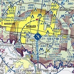
| Sectional chart |
|---|
|
CAUTION: Diagram may not be current
 Download PDF
of official airport diagram from the FAA
| Airport distance calculator |
|---|
|
|
| Sunrise and sunset |
|---|
|
Times for 01-Jun-2026
| | Local
(UTC-5) | | Zulu
(UTC) |
|---|
| Morning civil twilight | | 06:16 | | 11:16 |
| Sunrise | | 06:42 | | 11:42 |
| Sunset | | 20:20 | | 01:20 |
| Evening civil twilight | | 20:46 | | 01:46 |
|
| Current date and time |
|---|
| Zulu (UTC) | 01-Jun-2026 08:44:43 |
|---|
| Local (UTC-5) | 01-Jun-2026 03:44:43 |
|---|
|
| METAR |
|---|
| KMFE | 010753Z AUTO 10004KT 10SM CLR 26/24 A2991 RMK AO2 SLP126 T02610244 $
|
MMRX
10nm S | 010240Z 09007KT 8SM FEW240 28/24 A2987 RMK SLP111 52027 9// 8/001
|
KEBG
17nm N | 010835Z AUTO 07003KT 9SM OVC010 26/24 A2990 RMK AO2
|
|
| TAF |
|---|
| KMFE | 010520Z 0106/0206 12005KT P6SM SKC FM011400 11012KT P6SM SCT050 FM020200 13005KT P6SM FEW020
|
MMRX
10nm S | 010529Z 0106/0206 09007KT P6SM SCT250 TEMPO 0111/0115 4SM HZ BKN012 FM011800 12012KT P6SM SCT030 BKN250 FM020500 11007KT P6SM SCT250
|
|
| NOTAMs |
|---|
NOTAMs are issued by the DoD/FAA and will open in a separate window not controlled by AirNav.
|
|


