FAA INFORMATION EFFECTIVE 09 JULY 2026
Location
| FAA Identifier: | MQW |
| Lat/Long: | 32-05-49.1870N 082-52-45.8820W
32-05.819783N 082-52.764700W
32.0969964,-82.8794117
(estimated) |
| Elevation: | 202.1 ft. / 61.6 m (surveyed) |
| Variation: | 03W (1985) |
| From city: | 3 miles NE of MC RAE, GA |
| Time zone: | UTC -4 (UTC -5 during Standard Time) |
| Zip code: | 31037 |
Airport Operations
| Airport use: | Open to the public |
| Activation date: | 01/1968 |
| Control tower: | no |
| ARTCC: | JACKSONVILLE CENTER |
| FSS: | MACON FLIGHT SERVICE STATION |
| NOTAMs facility: | MCN (NOTAM-D service available) |
| Attendance: | UNATNND |
| Wind indicator: | lighted |
| Segmented circle: | yes |
| Lights: | ACTVT REIL RWY 21; PAPI RWYS 03 & 21, MIRL RWY 03/21 - CTAF. |
| Beacon: | white-green (lighted land airport)
Operates sunset to sunrise. |
Airport Communications
| CTAF: | 122.9 |
| WX AWOS-3PT: | 120.000 (229-868-7472) |
| WX AWOS-3 at EZM (15 nm NW): | 119.425 (478-374-9979) |
| WX AWOS-3 at AZE (17 nm SE): | 119.125 ((912) 375-0650) |
- APCH/DEP SVC PRVDD BY JACKSONVILLE ARTCC ON FREQS 127.575/269.025 (ALMA RCAG).
Nearby radio navigation aids
| VOR radial/distance | | VOR name | | Freq | | Var |
|---|
| DBNr190/28.1 | | DUBLIN VORTAC | | 113.10 | | 05W |
| VNAr102/32.2 | | VIENNA VORTAC | | 116.50 | | 01E |
| NDB name | | Hdg/Dist | | Freq | | Var | | ID |
|---|
| EASTMAN | | 102/14.1 | | 366 | | 04W | | EZM | . --.. -- |
| ONYUN | | 262/30.5 | | 372 | | 06W | | UQN | ..- --.- -. |
| FITZGERALD | | 041/35.8 | | 362 | | 05W | | SUR | ... ..- .-. |
Airport Services
| Fuel available: | 100LL JET-A+ |
| Parking: | tiedowns |
| Airframe service: | NONE |
| Powerplant service: | NONE |
| Bottled oxygen: | NONE |
| Bulk oxygen: | NONE |
Runway Information
Runway 3/21
| Dimensions: | 5001 x 75 ft. / 1524 x 23 m |
| Surface: | asphalt, in fair condition |
| Weight bearing capacity: | |
| Runway edge lights: | medium intensity |
| RUNWAY 3 | | RUNWAY 21 |
| Latitude: | 32-05.439585N | | 32-06.199975N |
| Longitude: | 082-52.952282W | | 082-52.577108W |
| Elevation: | 201.9 ft. | | 192.6 ft. |
| Traffic pattern: | left | | left |
| Runway heading: | 026 magnetic, 023 true | | 206 magnetic, 203 true |
| Markings: | nonprecision, in good condition | | nonprecision, in good condition |
| Visual slope indicator: | 2-light PAPI on left (3.00 degrees glide path) | | 2-light PAPI on left (3.00 degrees glide path) |
| Runway end identifier lights: | | | yes |
| Touchdown point: | yes, no lights | | yes, no lights |
| Obstructions: | 53 ft. trees, 677 ft. from runway, 307 ft. left of centerline, 9:1 slope to clear | | 66 ft. trees, 926 ft. from runway, 310 ft. left of centerline, 11:1 slope to clear |
Airport Ownership and Management from official FAA records
| Ownership: | Publicly-owned |
| Owner: | TELFAIR-WHEELER AIRPORT AUTH
P.O. BOX 192
MC RAE, GA 30411
Phone 229-315-1227 |
| Manager: | JIMMY RAY
P.O. BOX 192
MCRAE, GA 31055
Phone 229-315-1227 |
Additional Remarks
| - | FOR CD CTC JACKSONVILLE ARTCC AT 904-845-1592. |
| - | WEATHER DATA SOURCES: AWOS 3PT 120.000 (229) 868-7472 |
Instrument Procedures
NOTE: All procedures below are presented as PDF files. If you need a reader for these files, you should download the free Adobe Reader.NOT FOR NAVIGATION. Please procure official charts for flight.
FAA instrument procedures published for use from 09 July 2026 at 0901Z to 06 August 2026 at 0900Z.
IAPs - Instrument Approach Procedures |
|---|
| RNAV (GPS) RWY 03 | |
download (209KB) |
| RNAV (GPS) RWY 21 | |
download (177KB) |
| NOTE: Special Alternate Minimums apply | |
download (153KB) |
| NOTE: Special Take-Off Minimums/Departure Procedures apply | |
download (497KB) |
Other nearby airports with instrument procedures:
KEZM - Heart of Georgia Regional Airport (15 nm NW)
KAZE - Hazlehurst Airport (17 nm SE)
KVDI - Vidalia Regional Airport (26 nm E)
48A - Cochran Airport (27 nm NW)
KDBN - W H 'Bud' Barron Airport (29 nm N)
|
|

Road maps at:
MapQuest
Bing
Google
| Aerial photo |
|---|
WARNING: Photo may not be current or correct
 Photo by F. Allen Kyzer
Photo taken 21-Oct-2009
from a C-182.
Photo by F. Allen Kyzer
Photo taken 21-Oct-2009
from a C-182.
Do you have a better or more recent aerial photo of Telfair-Wheeler Airport that you would like to share? If so, please send us your photo.
|
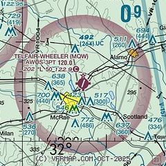
| Sectional chart |
|---|
|
| Airport distance calculator |
|---|
|
|
| Sunrise and sunset |
|---|
|
Times for 16-Jul-2026
| | Local
(UTC-4) | | Zulu
(UTC) |
|---|
| Morning civil twilight | | 06:10 | | 10:10 |
| Sunrise | | 06:37 | | 10:37 |
| Sunset | | 20:38 | | 00:38 |
| Evening civil twilight | | 21:05 | | 01:05 |
|
| Current date and time |
|---|
| Zulu (UTC) | 17-Jul-2026 02:20:04 |
|---|
| Local (UTC-4) | 16-Jul-2026 22:20:04 |
|---|
|
| METAR |
|---|
| KMQW | 170155Z AUTO 00000KT 10SM SCT110 26/24 A3005 RMK AO2 P0002
|
KEZM
15nm NW | 170155Z AUTO 27005KT 10SM SCT110 26/22 A3007 RMK AO2 LTG DSNT SE SW AND NW
|
KAZE
17nm SE | 170155Z AUTO 00000KT 10SM CLR 27/26 A3006 RMK AO2 T02710258
|
|
| TAF |
|---|
KWRB
47nm NW | 170000Z 1700/1801 30009KT 9999 BKN035 QNH3002INS TEMPO 1700/1701 4800 -TSRA BKN030CB BECMG 1704/1705 27006KT 9999 FEW025 SCT040 QNH3005INS BECMG 1719/1720 30009KT 9999 -SHRA BKN049 OVC065 QNH3005INS TEMPO 1721/1723 30010G15KT 4800 -TSRA BKN030CB OVC040 BECMG 1800/1801 29006KT 9999 NSW FEW030 SCT040 QNH3001INS TX33/1717Z TN24/1710Z
|
|
| NOTAMs |
|---|
NOTAMs are issued by the DoD/FAA and will open in a separate window not controlled by AirNav.
|
|


