FAA INFORMATION EFFECTIVE 27 NOVEMBER 2025
Location
| FAA Identifier: | MVC |
| Lat/Long: | 31-27-29.0000N 087-21-03.7000W
31-27.483333N 087-21.061667W
31.4580556,-87.3510278
(estimated) |
| Elevation: | 419.1 ft. / 127.7 m (surveyed) |
| Variation: | 02E (1975) |
| From city: | 3 miles S of MONROEVILLE, AL |
| Time zone: | UTC -6 (UTC -5 during Daylight Saving Time) |
| Zip code: | 36460 |
Airport Operations
| Airport use: | Open to the public |
| Control tower: | no |
| ARTCC: | ATLANTA CENTER |
| FSS: | ANNISTON FLIGHT SERVICE STATION |
| NOTAMs facility: | ANB (NOTAM-D service available) |
| Attendance: | MON-FRI 0800-2000, ALL SAT-SUN 0800-1700 |
| Wind indicator: | lighted |
| Segmented circle: | no |
| Lights: | ACTVT REIL RWY 03 & 21; PAPI RWY 03 & 21 - CTAF. |
| Beacon: | white-green (lighted land airport)
Operates sunset to sunrise. |
Airport Communications
| CTAF/UNICOM: | 123.0 |
| WX ASOS at GZH (16 nm E): | 133.425 (251-578-1438) |
- APCH/DEP SVC PRVDD BY ATLANTA ARTCC (MONROEVILLE RCAG) ON FREQS 118.55/267.9.
Nearby radio navigation aids
| VOR radial/distance | | VOR name | | Freq | | Var |
|---|
| MVC at field | | MONROEVILLE VORTAC | | 116.80 | | 04E |
Airport Services
| Fuel available: | 100LL JET-A+ |
| Parking: | tiedowns |
| Airframe service: | NONE |
| Powerplant service: | NONE |
| Bottled oxygen: | NONE |
| Bulk oxygen: | NONE |
Runway Information
Runway 3/21
| Dimensions: | 6028 x 100 ft. / 1837 x 30 m |
| Surface: | asphalt, in poor condition
CRACKING ON RWY |
| Weight bearing capacity: | |
| Runway edge lights: | medium intensity |
| RUNWAY 3 | | RUNWAY 21 |
| Latitude: | 31-27.050677N | | 31-27.914668N |
| Longitude: | 087-21.349195W | | 087-20.775302W |
| Elevation: | 412.2 ft. | | 418.5 ft. |
| Traffic pattern: | left | | left |
| Runway heading: | 028 magnetic, 030 true | | 208 magnetic, 210 true |
| Markings: | nonprecision, in fair condition | | nonprecision, in fair condition |
| Visual slope indicator: | 4-light PAPI on left (3.00 degrees glide path) | | 4-light PAPI on left (3.00 degrees glide path) |
| Runway end identifier lights: | yes | | yes |
| Touchdown point: | yes, no lights | | yes, no lights |
| Obstructions: | 73 ft. tree, 858 ft. from runway, 337 ft. right of centerline, 9:1 slope to clear | | 79 ft. tree, 848 ft. from runway, 342 ft. right of centerline, 8:1 slope to clear |
Airport Ownership and Management from official FAA records
| Ownership: | Publicly-owned |
| Owner: | MONROE COUNTY
PO BOX 8
MONROEVILLE, AL 36461
Phone 251-575-2081 |
| Manager: | JASON WELCH
PO BOX 191
MONROEVILLE, AL 36461
Phone 251-593-6828
ADDL CTC FBO MATT OKULY, MONROEVILLE AVIATION AT 251-575-4235. |
Instrument Procedures
NOTE: All procedures below are presented as PDF files. If you need a reader for these files, you should download the free Adobe Reader.NOT FOR NAVIGATION. Please procure official charts for flight.
FAA instrument procedures published for use from 27 November 2025 at 0901Z to 25 December 2025 at 0900Z.
IAPs - Instrument Approach Procedures |
|---|
| RNAV (GPS) RWY 03 | |
download (215KB) |
| RNAV (GPS) RWY 21 | |
download (245KB) |
| NOTE: Special Take-Off Minimums/Departure Procedures apply | |
download (522KB) |
Other nearby airports with instrument procedures:
KGZH - Evergreen Regional Airport/Middleton Field (16 nm E)
0R1 - Atmore Municipal Airport (27 nm S)
4R3 - Jackson Municipal Airport (28 nm W)
12J - Brewton Municipal Airport (28 nm SE)
61A - Camden Municipal Airport (31 nm N)
|
|

Road maps at:
MapQuest
Bing
Google
| Aerial photo |
|---|
WARNING: Photo may not be current or correct
 Photo courtesy of AirNav, LLC
Photo taken 11-Feb-2011
looking northwest.
Photo courtesy of AirNav, LLC
Photo taken 11-Feb-2011
looking northwest.
Do you have a better or more recent aerial photo of Monroe County Aeroplex Airport that you would like to share? If so, please send us your photo.
|
| Sectional chart |
|---|
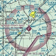
|
| Airport distance calculator |
|---|
|
|
| Sunrise and sunset |
|---|
|
Times for 15-Dec-2025
| | Local
(UTC-6) | | Zulu
(UTC) |
|---|
| Morning civil twilight | | 06:15 | | 12:15 |
| Sunrise | | 06:42 | | 12:42 |
| Sunset | | 16:47 | | 22:47 |
| Evening civil twilight | | 17:14 | | 23:14 |
|
| Current date and time |
|---|
| Zulu (UTC) | 15-Dec-2025 12:02:59 |
|---|
| Local (UTC-6) | 15-Dec-2025 06:02:59 |
|---|
|
| METAR |
|---|
KGZH
16nm E | 151153Z AUTO 01004KT 10SM CLR M05/M13 A3045 RMK AO2 SLP312 70008 T10501128 11022 21050 55001
|
|
| TAF |
|---|
KNSE
48nm S | 1507/1607 02008G18KT 9999 FEW150 QNH3039INS FM151600 VRB06KT 9999 FEW150 QNH3027INS AUTOMATED SENSOR METWATCH 1507 TIL 1510 TX09/1520Z TNM02/1510Z FN00317
|
|
| NOTAMs |
|---|
NOTAMs are issued by the DoD/FAA and will open in a separate window not controlled by AirNav.
|
|

