FAA INFORMATION EFFECTIVE 09 JULY 2026
Location
| FAA Identifier: | NSE |
| Lat/Long: | 30-43-20.9000N 087-01-26.0510W
30-43.348333N 087-01.434183W
30.7224722,-87.0239031
(estimated) |
| Elevation: | 199 ft. / 61 m (estimated) |
| Variation: | 02W (2010) |
| From city: | 4 miles N of MILTON, FL |
| Time zone: | UTC -5 (UTC -6 during Standard Time) |
| Zip code: | 32570 |
Airport Operations
| Airport use: | Private use. Permission required prior to landing |
| Control tower: | yes |
| ARTCC: | JACKSONVILLE CENTER |
| FSS: | GAINESVILLE FLIGHT SERVICE STATION
NOTAM PNS. |
| NOTAMs facility: | NSE (NOTAM-D service available) |
| Attendance: | MON-FRI 1200-0400Z++
CLSD SAT, SUN & HOL; OTR BY NOTAM. |
| Segmented circle: | no |
| Lights: | ACTVT MALSR RWY 14; PAPI RWY 05, 14, 23 & 28; HIRL RWY 14, RWY 05/23 - CTAF. |
| Beacon: | white-white-green (lighted military airport)
Operates sunset to sunrise. |
Airport Communications
| CTAF: | 121.4 |
| ATIS: | 140.0 290.325 |
| WX ASOS: | PHONE 850-623-7241 |
| NORTH WHITING GROUND: | 251.15 [1245-0445Z++ MON-FRI, CLSD SAT, SUN & HOL; OTR BY NOTAM.] |
| NORTH WHITING TOWER: | 121.4 306.925 340.2 [1245-0445Z++ MON-FRI, CLSD SAT, SUN & HOL; OTR BY NOTAM.] |
| PENSACOLA APPROACH: | 127.35 |
| PENSACOLA DEPARTURE: | 127.35 |
| CLEARANCE DELIVERY: | 257.775 |
| BASE OPS: | 233.7 |
| CLASS C: | 127.35 |
| EMERG: | 121.5 243.0 |
| PMSV METRO: | 316.95 |
| WX ASOS at NDZ (1.5 nm S): | PHONE 850-623-7210 |
| WX ASOS at PNS (17 nm SW): | 121.25 (850-436-4799) |
| WX AWOS-3PT at 12J (20 nm N): | 119.325 (251-809-2987) |
Nearby radio navigation aids
| VOR radial/distance | | VOR name | | Freq | | Var |
|---|
| CEWr248/18.8 | | CRESTVIEW VORTAC | | 115.90 | | 03E |
| NUNr046/(22.0) | | SAUFLEY VOR | | 112.25 | | 01E |
Airport Services
| Fuel available: | 100LL |
| Airframe service: | NONE |
| Powerplant service: | NONE |
| Bottled oxygen: | NONE |
| Bulk oxygen: | NONE |
Runway Information
Runway 5/23
| Dimensions: | 6003 x 200 ft. / 1830 x 61 m |
| Surface: | asphalt, in fair condition |
| Weight bearing capacity: | |
| Runway edge lights: | high intensity |
| RUNWAY 5 | | RUNWAY 23 |
| Latitude: | 30-42.911667N | | 30-43.585667N |
| Longitude: | 087-01.978000W | | 087-01.138333W |
| Elevation: | 169.3 ft. | | 182.6 ft. |
| Traffic pattern: | left | | left |
| Runway heading: | 049 magnetic, 047 true | | 229 magnetic, 227 true |
| Markings: | , in fair condition | | , in fair condition |
| Visual slope indicator: | 4-light PAPI on left (3.00 degrees glide path) | | 4-light PAPI on left (3.00 degrees glide path) |
| Touchdown point: | yes, no lights | | yes, no lights |
Runway 14/32
| Dimensions: | 6001 x 200 ft. / 1829 x 61 m |
| Surface: | asphalt, in fair condition |
| Weight bearing capacity: | |
| Runway edge lights: | high intensity |
| RUNWAY 14 | | RUNWAY 32 |
| Latitude: | 30-43.810667N | | 30-43.085333N |
| Longitude: | 087-01.700167W | | 087-00.920167W |
| Elevation: | 198.8 ft. | | 159.1 ft. |
| Traffic pattern: | left | | left |
| Runway heading: | 139 magnetic, 137 true | | 319 magnetic, 317 true |
| Markings: | , in fair condition | | , in fair condition |
| Visual slope indicator: | 4-light PAPI on left (3.00 degrees glide path) | | 4-light PAPI on left (3.00 degrees glide path) |
| Approach lights: | MALSR: 1,400 foot medium intensity approach lighting system with runway alignment indicator lights | | |
| Touchdown point: | yes, no lights | | yes, no lights |
| Instrument approach: | ILS/DME | | |
Airport Ownership and Management from official FAA records
| Ownership: | U.S. Navy |
| Owner: | US NAVY
OCEANOGRAPHIC OFC-CODE 3142
WASHINGTON, DC 20373 |
| Manager: | COMMANDING OFFICER
NAVAL AIR STATION WHITING FLD
MILTON, FL 32570 |
Additional Remarks
| - | RSTD: PPR FOR TSNT PRAC APCH & LDG; LTD TSNT PRK & SVC AVBL. CTC DUTY OPS FOR PPR INFO, PPR 24 HR PN C850-623-7475 OR E-MAIL WHTG_NASWF_AIROPS_AFM@NAVY.MIL. CTC AIRFIELD MANAGER FOR CALP, C850-665-6133 OR 850-623-7329 OR E-MAIL: LEANN.M.BAIR.CIV@US.NAVY.MIL |
| - | CTN: TRNG OPS INVOF ALL HRS; PONDING OCRS AFT RAIN - BRAP. |
| - | SERVICE-JASU-1(NC-8) FUEL - F24 TRAN ALERT. LTD TRAN LINE SVC AVBL 1400-220Z++ MON-FRI ONLY. |
| - | TWY Z & 200 FT INWARD FM COMPASS ROSE OF TWY A NOT VSB FM ATCT. |
| - | DD-1801 WX CODES OBTAINED AT HTTPS:/FWB.METOC.NAVY.MIL. METOC AFT HR - AWS/NORFOLK 1-888-745-6899. |
| - | SMT WHITING FLD FP - FAX C850-623-7356 OR WHTG_NASWF_BASEOPS.FCT@NAVY.MIL; CFM FP - FPG DISPATCH D868-7598/7597/7654 OR C850-623-7598/7597/7654. |
Instrument Procedures
NOTE: All procedures below are presented as PDF files. If you need a reader for these files, you should download the free Adobe Reader.NOT FOR NAVIGATION. Please procure official charts for flight.
FAA instrument procedures published for use from 09 July 2026 at 0901Z to 06 August 2026 at 0900Z.
IAPs - Instrument Approach Procedures |
|---|
| ILS Y OR LOC Y RWY 14 **CHANGED** | |
download (132KB) |
| ILS Z OR RNAV (GPS) RWY 14 **CHANGED** | |
download (145KB) |
| RNAV (GPS) RWY 23 **CHANGED** | |
download (113KB) |
| TACAN RWY 05 **CHANGED** | |
download (130KB) |
| TACAN RWY 14 **CHANGED** | |
download (121KB) |
| TACAN RWY 23 **CHANGED** | |
download (126KB) |
| Radar Approach Procedures available | |
download (174KB) |
| NOTE: Special Take-Off Minimums/Departure Procedures apply | |
download (404KB) |
Other nearby airports with instrument procedures:
KNDZ - Whiting Field Naval Air Station South (2 nm S)
2R4 - Peter Prince Field Airport (5 nm S)
KPNS - Pensacola International Airport (17 nm SW)
12J - Brewton Municipal Airport (20 nm N)
KHRT - Hurlburt Field Airport (25 nm SE)
|
|

Road maps at:
MapQuest
Bing
Google
| Aerial photo |
|---|
WARNING: Photo may not be current or correct
 looking northwest.
KNDZ in foreground (bottom of photo), KNSE in background (top of photo)
Do you have a better or more recent aerial photo of Whiting Field Naval Air Station North that you would like to share? If so, please send us your photo.
|
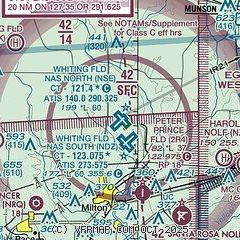
| Sectional chart |
|---|
|
 Download PDF
of official airport diagram from the FAA
| Airport distance calculator |
|---|
|
|
| Sunrise and sunset |
|---|
|
Times for 19-Jul-2026
| | Local
(UTC-5) | | Zulu
(UTC) |
|---|
| Morning civil twilight | | 05:32 | | 10:32 |
| Sunrise | | 05:59 | | 10:59 |
| Sunset | | 19:50 | | 00:50 |
| Evening civil twilight | | 20:17 | | 01:17 |
|
| Current date and time |
|---|
| Zulu (UTC) | 19-Jul-2026 15:30:54 |
|---|
| Local (UTC-5) | 19-Jul-2026 10:30:54 |
|---|
|
| METAR |
|---|
| KNSE | 191456Z AUTO VRB03KT 10SM CLR 29/24 A2999 RMK AO2 SLP141 T02890244 50003 PWINO $
|
| KNDZ | 191456Z AUTO 02005KT 10SM CLR 30/24 A3000 RMK AO2 SLP142 T03000239 50003 $
|
KNFJ
13nm S | 191448Z AUTO 03008KT 10SM OVC001 30/23 A3000 RMK AO2 SLP163 T03000233 $
|
KPNS
17nm SW | 191453Z AUTO 01005KT 10SM CLR 31/23 A2999 RMK AO2 SLP155 T03060233 51003 $
|
|
| TAF |
|---|
| KNSE | 190700Z 1907/2007 VRB06KT 9999 VCTS BKN050CB QNH2986INS TEMPO 1907/1913 VRB15G35KT 3200 TSRA BKN010CB BKN050 BECMG 1913/1915 VRB06KT 9999 VCTS BKN040CB QNH2983INS TEMPO 1916/1922 VRB20G35KT 2400 +TSRA FM192300 VRB06KT 9999 FEW030 QNH2982INS TX33/1917Z TN24/1912Z FN00276
|
KPNS
17nm SW | 191120Z 1912/2012 00000KT P6SM FEW040 SCT100 FM191500 06008KT P6SM FEW027 SCT110 PROB30 1917/1923 2SM TSRA BKN035CB FM200100 VRB03KT P6SM SCT100
|
|
| NOTAMs |
|---|
NOTAMs are issued by the DoD/FAA and will open in a separate window not controlled by AirNav.
|
|


