FAA INFORMATION EFFECTIVE 27 NOVEMBER 2025
Location
| FAA Identifier: | 2R4 |
| Lat/Long: | 30-38-15.4410N 086-59-37.1510W
30-38.257350N 086-59.619183W
30.6376225,-86.9936531
(estimated) |
| Elevation: | 81.7 ft. / 24.9 m (surveyed) |
| Variation: | 01W (2000) |
| From city: | 3 miles E of MILTON, FL |
| Time zone: | UTC -6 (UTC -5 during Daylight Saving Time) |
| Zip code: | 32583 |
Airport Operations
| Airport use: | Open to the public |
| Activation date: | 04/1940 |
| Control tower: | no |
| ARTCC: | JACKSONVILLE CENTER |
| FSS: | GAINESVILLE FLIGHT SERVICE STATION |
| NOTAMs facility: | GNV (NOTAM-D service available) |
| Attendance: | 0700-DUSK |
| Wind indicator: | lighted |
| Segmented circle: | yes |
| Lights: | ACTVT REIL RY 18 & 36; MIRL RY 18/36 - CTAF. |
| Beacon: | white-green (lighted land airport)
Operates sunset to sunrise. |
Airport Communications
| CTAF/UNICOM: | 122.975 |
| PENSACOLA APPROACH: | 124.85 |
| PENSACOLA DEPARTURE: | 124.85 |
| WX ASOS at NDZ (4 nm N): | PHONE 850-623-7210 |
| WX ASOS at NSE (5 nm N): | PHONE 850-623-7241 |
| WX ASOS at PNS (14 nm SW): | 121.25 (850-436-4799) |
Nearby radio navigation aids
| VOR radial/distance | | VOR name | | Freq | | Var |
|---|
| CEWr232/19.8 | | CRESTVIEW VORTAC | | 115.90 | | 03E |
| NUNr060/(20.3) | | SAUFLEY VOR | | 112.25 | | 01E |
Airport Services
| Fuel available: | 100LL JET-A1+
100LL:FUEL 24 HR CREDIT CARD SVC AVBL. |
| Parking: | tiedowns |
| Airframe service: | MAJOR |
| Powerplant service: | MAJOR |
| Bottled oxygen: | NONE |
| Bulk oxygen: | NONE |
Runway Information
Runway 18/36
| Dimensions: | 3703 x 75 ft. / 1129 x 23 m |
| Surface: | asphalt, in good condition |
| Weight bearing capacity: | | PCN 9 /F/A/X/T | | Single wheel: | 22.0 |
|
| Runway edge lights: | medium intensity |
| Runway edge markings: | RWY 36 MRKGS DISCOLORED AND FADED. |
| RUNWAY 18 | | RUNWAY 36 |
| Latitude: | 30-38.562623N | | 30-37.952065N |
| Longitude: | 086-59.609273W | | 086-59.629158W |
| Elevation: | 78.7 ft. | | 79.2 ft. |
| Traffic pattern: | right | | left |
| Runway heading: | 183 magnetic, 182 true | | 003 magnetic, 002 true |
| Markings: | basic, in poor condition | | nonprecision, in poor condition |
| Runway end identifier lights: | yes | | yes |
| Touchdown point: | yes, no lights | | yes, no lights |
| Obstructions: | 21 ft. trees, 480 ft. from runway, 115 ft. right of centerline, 13:1 slope to clear | | 39 ft. trees, 650 ft. from runway, 160 ft. right of centerline, 11:1 slope to clear |
Airport Ownership and Management from official FAA records
| Ownership: | Publicly-owned |
| Owner: | SANTA ROSA COUNTY
6495 CAROLINE STREET
MILTON, FL 32570
Phone 850-983-1855
CTC PERSON: BRAD BAKER |
| Manager: | JARED LOWE
6491 CAROLINE ST, SUITE 4
MILTON, FL 32570
Phone 850-983-1817
ARPT PHYSICAL ADDRESS: 5550 N ARPT RD. |
Additional Remarks
| - | BE ALERT ARPT SITUATED IN CUT-OFF OF NAS WHITING CASS C AIRSPACE LOCATED 1400 FT OVERHEAD WITHIN 1 MILE FROM THE CENTER OF THE ARPT ON THREE SIDES TO THE EAST, NORTH, AND WEST FROM SURFACE TO 4200 FT. |
| - | GCO AVBL ON FREQ 121.725 THRU PENSACOLA APCH. |
| - | INTENSIVE FLIGHT TRAINING INVOF ARPT. |
| - | LIMITED PARKING ON WEST RAMP FOR TRANSIENT ACFT URGED TO BRING TIE-DOWN ROPES FOR EAST RAMP PARKING. |
| - | FOR CD IF UNA VIA GCO CTC JACKSONVILLE ARTCC AT 904-845-1592. |
| - | LNDG AND TKOFS IN THE GRASS ARE AT YOUR OWN RISK. |
Instrument Procedures
NOTE: All procedures below are presented as PDF files. If you need a reader for these files, you should download the free Adobe Reader.NOT FOR NAVIGATION. Please procure official charts for flight.
FAA instrument procedures published for use from 27 November 2025 at 0901Z to 25 December 2025 at 0900Z.
IAPs - Instrument Approach Procedures |
|---|
| RNAV (GPS) RWY 36 | |
download (217KB) |
| NOTE: Special Take-Off Minimums/Departure Procedures apply | |
download (406KB) |
Other nearby airports with instrument procedures:
KNDZ - Whiting Field Naval Air Station South (4 nm N)
KNSE - Whiting Field Naval Air Station North (5 nm N)
KPNS - Pensacola International Airport (14 nm SW)
KHRT - Hurlburt Field Airport (20 nm SE)
KNPA - Pensacola Naval Air Station (Forrest Sherman Field) Airport (24 nm SW)
|
|

Road maps at:
MapQuest
Bing
Google
| Aerial photo |
|---|
WARNING: Photo may not be current or correct
 Photo courtesy of AirNav, LLC
Photo taken 05-May-2011
looking southwest.
Photo courtesy of AirNav, LLC
Photo taken 05-May-2011
looking southwest.
Do you have a better or more recent aerial photo of Peter Prince Field Airport that you would like to share? If so, please send us your photo.
|
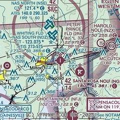
| Sectional chart |
|---|
|
CAUTION: Diagram may not be current

| Airport distance calculator |
|---|
|
|
| Sunrise and sunset |
|---|
|
Times for 21-Dec-2025
| | Local
(UTC-6) | | Zulu
(UTC) |
|---|
| Morning civil twilight | | 06:16 | | 12:16 |
| Sunrise | | 06:42 | | 12:42 |
| Sunset | | 16:50 | | 22:50 |
| Evening civil twilight | | 17:17 | | 23:17 |
|
| Current date and time |
|---|
| Zulu (UTC) | 21-Dec-2025 13:46:36 |
|---|
| Local (UTC-6) | 21-Dec-2025 07:46:36 |
|---|
|
| METAR |
|---|
KNDZ
4nm N | 211337Z AUTO 00000KT 3SM BR BKN003 13/13 A3021 RMK AO2 T01330133 $
|
KNSE
5nm N | 211336Z AUTO 00000KT 1/4SM FG VV001 13/13 A3021 RMK AO2 T01280128 $
|
KNFJ
8nm S | 211248Z AUTO 11004KT 10SM FEW033 SCT060 14/14 A3020 RMK AO2 SLP231 T01440139 $
|
KPNS
13nm SW | 211253Z AUTO 08004KT 10SM FEW033 SCT041 BKN060 14/14 A3018 RMK AO2 SLP223 T01440139
|
|
| TAF |
|---|
KNSE
5nm N | 2107/2207 VRB06KT 9999 FEW030 SCT060 QNH3010INS BECMG 2108/2110 VRB06KT 9999 VCSH SCT010 BKN020 QNH3012INS BECMG 2112/2114 VRB06KT 8000 BR VCSH SCT008 BKN020 BKN030 BKN100 QNH3015INS AUTOMATED SENSOR METWATCH 2107 TIL 2212 TX24/2118Z TN12/2109Z FN00296
|
KPNS
13nm SW | 211123Z 2112/2212 08004KT P6SM OVC060 FM211400 12005KT P6SM OVC035 FM220300 08004KT 6SM BR OVC015
|
|
| NOTAMs |
|---|
NOTAMs are issued by the DoD/FAA and will open in a separate window not controlled by AirNav.
|
|


