FAA INFORMATION EFFECTIVE 22 JANUARY 2026
Location
| FAA Identifier: | RKP |
| Lat/Long: | 28-05-10.4000N 097-02-37.3000W
28-05.173333N 097-02.621667W
28.0862222,-97.0436944
(estimated) |
| Elevation: | 23.8 ft. / 7.3 m (surveyed) |
| Variation: | 06E (2000) |
| From city: | 4 miles N of ROCKPORT, TX |
| Time zone: | UTC -6 (UTC -5 during Daylight Saving Time) |
| Zip code: | 78382 |
Airport Operations
| Airport use: | Open to the public |
| Activation date: | 04/1944 |
| Control tower: | no |
| ARTCC: | HOUSTON CENTER |
| FSS: | SAN ANGELO FLIGHT SERVICE STATION |
| NOTAMs facility: | RKP (NOTAM-D service available) |
| Attendance: | 0730-1730 |
| Wind indicator: | lighted |
| Segmented circle: | yes |
| Lights: | MIRL RWY 14/32 & 18/36 PRESET LOW INTST. TO INCR INTST & ACTVT REIL 14 - CTAF. |
| Beacon: | white-green (lighted land airport)
Operates sunset to sunrise. |
Airport Communications
| CTAF/UNICOM: | 123.05 |
| WX ASOS: | 119.275 (361-729-2372) |
| CORPUS APPROACH: | 120.9 |
| CORPUS DEPARTURE: | 120.9 |
| CLEARANCE DELIVERY: | 121.7 |
| WX AWOS-3 at TFP (14 nm SW): | 118.775 (361-758-8961) |
| WX AWOS-3 at RAS (17 nm S): | 118.425 (361-749-0537) |
Nearby radio navigation aids
| VOR radial/distance | | VOR name | | Freq | | Var |
|---|
| CRPr054/23.9 | | CORPUS CHRISTI VORTAC | | 115.50 | | 09E |
Airport Services
| Fuel available: | 100LL JET-A+ |
| Parking: | hangars and tiedowns |
| Airframe service: | MAJOR |
| Powerplant service: | MAJOR |
Runway Information
Runway 14/32
| Dimensions: | 5608 x 100 ft. / 1709 x 30 m |
| Surface: | asphalt, in good condition |
| Weight bearing capacity: | | Single wheel: | 45.0 | | Double wheel: | 80.0 | | Double tandem: | 140.0 |
|
| Runway edge lights: | medium intensity |
| RUNWAY 14 | | RUNWAY 32 |
| Latitude: | 28-05.559247N | | 28-04.796918N |
| Longitude: | 097-03.094452W | | 097-02.502742W |
| Elevation: | 14.8 ft. | | 23.8 ft. |
| Traffic pattern: | left | | right |
| Runway heading: | 139 magnetic, 145 true | | 319 magnetic, 325 true |
| Displaced threshold: | no | | 565 ft. |
| Markings: | nonprecision, in fair condition | | nonprecision, in fair condition |
| Visual slope indicator: | 4-light PAPI on left (3.00 degrees glide path) | | 4-light PAPI on left (3.00 degrees glide path) |
| Runway end identifier lights: | yes | | no |
| Touchdown point: | yes, no lights | | yes, no lights |
| Obstructions: | 10 ft. brush, 560 ft. from runway, 36:1 slope to clear | | 33 ft. pline, marked, 872 ft. from runway, 250 ft. right of centerline, 20:1 slope to clear
APCH SLOPE 50:1 FM DSPLCD THR. |
Runway 18/36
| Dimensions: | 4498 x 100 ft. / 1371 x 30 m |
| Surface: | asphalt, in excellent condition |
| Weight bearing capacity: | | Single wheel: | 45.0 | | Double wheel: | 80.0 | | Double tandem: | 140.0 |
|
| Runway edge lights: | medium intensity |
| RUNWAY 18 | | RUNWAY 36 |
| Latitude: | 28-05.531678N | | 28-04.801692N |
| Longitude: | 097-02.325397W | | 097-02.477455W |
| Elevation: | 20.0 ft. | | 23.1 ft. |
| Traffic pattern: | right | | left |
| Runway heading: | 184 magnetic, 190 true | | 004 magnetic, 010 true |
| Markings: | nonprecision, in good condition | | nonprecision, in good condition |
| Visual slope indicator: | 2-light PAPI on left (3.00 degrees glide path) | | 2-light PAPI on left (3.00 degrees glide path) |
| Touchdown point: | yes, no lights | | yes, no lights |
| Obstructions: | 30 ft. trees, 1035 ft. from runway, 27:1 slope to clear | | 42 ft. pline, lighted, 922 ft. from runway, 220 ft. right of centerline, 17:1 slope to clear |
Airport Ownership and Management from official FAA records
| Ownership: | Publicly-owned |
| Owner: | ARANSAS COUNTY
2740 UNIT 1 HWY 35 N
ROCKPORT, TX 78382
Phone 817-480-8861 |
| Manager: | MIKE GEER
PO BOX 1270
ROCKPORT, TX 78381
Phone 361-790-0141 |
Additional Remarks
| - | CREW CARS AVAILABLE FIRST COME OR RESERVATION. |
| - | CREW REST FACILITY INCLUDING SLEEP ROOMS AND SHOWERS AVAILABLE WITH PRIOR COORDINATION W/ARPT. |
Instrument Procedures
NOTE: All procedures below are presented as PDF files. If you need a reader for these files, you should download the free Adobe Reader.NOT FOR NAVIGATION. Please procure official charts for flight.
FAA instrument procedures published for use from 22 January 2026 at 0901Z to 19 February 2026 at 0900z.
IAPs - Instrument Approach Procedures |
|---|
| RNAV (GPS) RWY 14 | |
download (279KB) |
| RNAV (GPS) RWY 18 | |
download (278KB) |
| RNAV (GPS) RWY 32 | |
download (309KB) |
| RNAV (GPS) RWY 36 | |
download (265KB) |
| VOR OR TACAN-A | |
download (232KB) |
| NOTE: Special Alternate Minimums apply | |
download (118KB) |
| NOTE: Special Take-Off Minimums/Departure Procedures apply | |
download (105KB) |
Other nearby airports with instrument procedures:
KTFP - Ingleside Regional Airport (14 nm SW)
KRAS - Mustang Beach Airport (17 nm S)
T69 - Sinton Airport (27 nm W)
KNGP - Corpus Christi Naval Air Station (Truax Field) Airport (27 nm SW)
KCRP - Corpus Christi International Airport (31 nm SW)
|
|

Road maps at:
MapQuest
Bing
Google
| Aerial photo |
|---|
WARNING: Photo may not be current or correct
 Photo by Jon-Scott Dorsett
Photo taken 19-Mar-2009
Photo by Jon-Scott Dorsett
Photo taken 19-Mar-2009
Do you have a better or more recent aerial photo of Aransas County Airport that you would like to share? If so, please send us your photo.
|
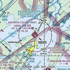
| Sectional chart |
|---|
|
CAUTION: Diagram may not be current

| Airport distance calculator |
|---|
|
|
| Sunrise and sunset |
|---|
|
Times for 30-Jan-2026
| | Local
(UTC-6) | | Zulu
(UTC) |
|---|
| Morning civil twilight | | 06:53 | | 12:53 |
| Sunrise | | 07:17 | | 13:17 |
| Sunset | | 18:06 | | 00:06 |
| Evening civil twilight | | 18:30 | | 00:30 |
|
| Current date and time |
|---|
| Zulu (UTC) | 30-Jan-2026 22:22:22 |
|---|
| Local (UTC-6) | 30-Jan-2026 16:22:22 |
|---|
|
| METAR |
|---|
| KRKP | 302153Z AUTO 34010KT 9SM CLR 12/01 A3031 RMK AO2 SLP265 T01220006
|
KRAS
17nm S | 302155Z AUTO 35012KT 10SM BKN120 13/00 A3033 RMK AO2 T01270002
|
|
| TAF |
|---|
KNGP
27nm SW | 3015/3115 36018G28KT 9999 SCT180 BKN250 520003 QNH3028INS TEMPO 3016/3021 36014G22KT FM302100 36014KT 9999 FEW180 BKN250 500000 QNH3029INS FM310500 01010KT 9999 FEW180 SCT250 QNH3034INS FM310900 02012KT 9999 FEW250 QNH3036INS TX17/3021Z TN04/3113Z FN20085
|
KCRP
31nm SW | 301720Z 3018/3118 01015G23KT P6SM BKN150 OVC250 FM310000 36008KT P6SM OVC250 FM311300 02014G22KT P6SM SKC
|
|
| NOTAMs |
|---|
NOTAMs are issued by the DoD/FAA and will open in a separate window not controlled by AirNav.
|
|


