FAA INFORMATION EFFECTIVE 02 OCTOBER 2025
Location
| FAA Identifier: | SAN |
| Lat/Long: | 32-44-00.8260N 117-11-22.7880W
32-44.013767N 117-11.379800W
32.7335628,-117.1896633
(estimated) |
| Elevation: | 16.8 ft. / 5 m (estimated) |
| Variation: | 11E (2020) |
| From city: | 2 miles W of SAN DIEGO, CA |
| Time zone: | UTC -7 (UTC -8 during Standard Time) |
| Zip code: | 92101 |
Airport Operations
| Airport use: | Open to the public |
| Activation date: | 04/1940 |
| Control tower: | yes |
| ARTCC: | LOS ANGELES CENTER |
| FSS: | SAN DIEGO FLIGHT SERVICE STATION |
| NOTAMs facility: | SAN (NOTAM-D service available) |
| Attendance: | CONTINUOUS |
| Wind indicator: | lighted |
| Segmented circle: | no |
| Beacon: | white-green (lighted land airport)
Operates sunset to sunrise. |
| Fire and rescue: | ARFF index D |
| International operations: | international airport of entry |
Airport Communications
| WX ASOS: | PHONE 619-296-8934 |
| LINDBERGH GROUND: | 123.9 |
| LINDBERGH TOWER: | 118.3 338.225 |
| SOCAL APPROACH: | 119.6 ;WEST 124.35 ;EAST |
| SOCAL DEPARTURE: | 119.6 ;WEST 124.35 ;EAST |
| CLEARANCE DELIVERY: | 125.9 |
| BARET STAR: | 124.35 |
| BAYVU5 STAR: | 125.3 |
| CLASS B: | 124.35 ;062-109 SAN 14,000 FT & BLW 125.3 ;294-332 SAN 7,000 FT-15,000 F |
| CLSSY DP: | 119.6 |
| COMIX STAR: | 125.3 |
| CWARD DP: | 119.6 |
| D-ATIS: | 134.8 |
| ECHHO DP: | 124.35 ;EAST 125.3 ;WEST |
| FALCC DP: | 124.35 ;EAST 125.3 ;WEST |
| LUCKI STAR: | 124.35 |
| MMOTO DP: | 124.35 ;EAST 125.3 ;WEST |
| PADRZ DP: | 119.6 |
| PLYYA STAR: | 128.1 |
| POGGI DP: | 125.15 |
| SAYOW DP: | 124.35 |
| TOPGN STAR: | 124.35 |
| ZZOOO DP: | 125.15 |
| WX ASOS at MYF (6 nm NE): | 126.9 (858-576-4337) |
| WX ASOS at NRS (11 nm S): | PHONE 619-437-9890 |
| WX AWOS-3P at SEE (12 nm NE): | 125.45 (619-449-1228) |
| WX ASOS at SDM (14 nm SE): | 132.35 (619-333-1055) |
- COMMUNICATIONS PRVDD BY SAN DIEGO RADIO ON FREQ 122.2 (MONTGOMERY RCO).
- ASDE-X IN USE. OPERATE TRANSPONDERS WITH ALTITUDE REPORTING MODE AND ADS-B (IF EQUIPPED) ENABLED ON ALL AIRPORT SURFACES.
Nearby radio navigation aids
| VOR radial/distance | | VOR name | | Freq | | Var |
|---|
| MZBr133/3.4 | | MISSION BAY VORTAC | | 117.80 | | 15E |
| PGYr291/13.0 | | POGGI VORTAC | | 116.45 | | 14E |
| TIJr302/16.7 | | TIJUANA VOR/DME | | 116.50 | | 12E |
| OCNr144/32.5 | | OCEANSIDE VORTAC | | 115.30 | | 15E |
| JLIr216/39.0 | | JULIAN VORTAC | | 113.75 | | 15E |
Airport Services
| Fuel available: | 100LL JET-A |
| Parking: | hangars and tiedowns |
| Airframe service: | MINOR |
| Powerplant service: | MINOR |
| Bottled oxygen: | NONE |
| Bulk oxygen: | HIGH/LOW |
Runway Information
Runway 9/27
| Dimensions: | 9401 x 200 ft. / 2865 x 61 m |
| Surface: | asphalt/concrete/grooved, in excellent condition |
| Weight bearing capacity: | | Single wheel: | 120.0 | | Double wheel: | 250.0 | | Double tandem: | 550.0 | | Dual double tandem: | 1120.0 |
|
| Runway edge lights: | high intensity |
| RUNWAY 9 | | RUNWAY 27 |
| Latitude: | 32-44.227345N | | 32-43.800090N |
| Longitude: | 117-12.261387W | | 117-10.498298W |
| Elevation: | 13.9 ft. | | 16.4 ft. |
| Traffic pattern: | left | | right |
| Runway heading: | 095 magnetic, 106 true | | 275 magnetic, 286 true |
| Displaced threshold: | 1000 ft. | | 1810 ft. |
| Declared distances: | TORA:8280 TODA:9401 ASDA:8280 LDA:7280 | | TORA:9401 TODA:9401 ASDA:9401 LDA:7591 |
| Markings: | precision, in good condition | | precision, in good condition |
| Visual slope indicator: | 4-light PAPI on left (3.30 degrees glide path) | | 4-light PAPI on right (3.50 degrees glide path)
PAPI UNUSBL BYD 5 DEG L & R OF CNTLN. |
| RVR equipment: | touchdown, rollout | | touchdown, rollout |
| Approach lights: | MALSR: 1,400 foot medium intensity approach lighting system with runway alignment indicator lights | | MALS: 1,400 foot medium intensity approach lighting system
MALS RWY 27 THR TO 1400'. |
| Runway end identifier lights: | no | | no |
| Centerline lights: | yes | | yes |
| Touchdown point: | yes, lighted | | yes, lighted |
| Instrument approach: | ILS/DME | | LOC/DME |
| Obstructions: | 31 ft. tree, 674 ft. from runway, 385 ft. left of centerline, 15:1 slope to clear
APCH RATIO 44:1 TO DSPLCD THR. | | 61 ft. sign, 250 ft. from runway, 500 ft. right of centerline
+40' LGT POLE 110' FROM RWY END 260' RIGHT. |
Airport Ownership and Management from official FAA records
| Ownership: | Publicly-owned |
| Owner: | SAN DIEGO CNTY REG ARPT AUTHORITY
2417 MCCAIN ROAD
SAN DIEGO, CA 92101-1022
Phone 619-400-2710 |
| Manager: | KIMBERLY BECKER
PO BOX 82776
SAN DIEGO, CA 92138-2776
Phone 619-400-2710 |
Additional Remarks
| A39-09/27 | PCR VALUE: 851/F/A/X/T |
| E60-27 | ENGINEERED MATERIALS ARRESTING SYSTEM (EMAS) 315 FT IN LENGTH BY 218 FT IN WIDTH LCTD AT DER 27. |
| - | TO REDUCE JET BLAST IMPACT AT N END OF TWY F ACFT WILL NOT START ENG UNTIL 800 FT FM N END OF TWY F; ABEAM THE SECOND PARKING PAD. |
| - | ULTRALIGHT ACFT PROHIBITED ON AP. |
| - | 747 AND LARGER ACFT ARE PROHIBITED FM MAKING INTERSECTION TKOFS. |
| - | INTERMITTENT PRESENCE OF BIRDS ON AND INVOF OF ARPT. |
| - | TERRAIN & BLDGS TO 500' MSL N & E WITHIN 1 1/2 MI. |
| - | CROSS-BLEED ENGINE STARTS PERMITTED ONLY ON PARALLEL TWY WITH ACFT ALIGNED ON TWY CNTRLN. |
| - | OUTBOARD ENGINES OF FOUR-ENGINE ACFT ARE TO BE KEPT AT IDLE POWER FOR ALL GND MANEUVERING. |
| - | PILOTS REQUIRED TO CTC ATCT GROUND CONTROLLER PRIOR TO PUSHBACK, TOW OUT AND TAXI FOR TRAFFIC ADVISORIES. |
| - | MILITARY ACFT ON OFFICIAL BUSINESS ONLY CONTACT ARPT OPS AT 619-400-2710 FOR PPR. |
| - | PRACTICE APPROACHES AND TGL PROHIBITED. |
| - | TWY C EDGE LGTS OTS INDEFLY. |
| - | ACFT CROSSING RY 09/27 ON TWY C6, HOLD SHORT OF TWY C6 FACING WEST ON TWY C, PARALLEL TO RY. |
| - | DUE TO PAEW ON RY 09-27, 30 MINUTE PPR 0830-1230Z FOR ALL LANDINGS AND DEPARTURES CALL 619-400-2710. |
| - | 30 MIN PPR (619-400-2710) FOR ACFT WITH OVER 171 FT WINGSPAN. |
| - | IN THE EVENT OF A DIVERSION OR IRREGULAR OPERATIONS EVENTS, ACFT OPERATORS CONTACT THE APT DUTY MGR (619) 400-2710 FOR PPR DUE TO LIMITATIONS ASSOCIATED WITH HANDLING DIVERTED FLTS. LIMITATIONS INCLUDE RESTRICTED GATE SPACE, CUSTOMS SERVICES AS WELL AS ACFT SERVICING & PARKING. |
| - | TAXIING ACFT ARE PROHIBITED FROM PASSING TO THE SOUTH OF ACFT LCTD ON TWY B INTO ALLEY LCTD BTWN GATES 7 AND 14. |
| - | TAXIING ACFT SHALL FOLLOW LEAD-IN LINES UNTIL THE NOSE WHEEL OF THE ACFT HAS ENTERED THE NON-MOVEMENT AREA OF THE ALLEY. |
| - | FOR ACCESS TO/FR TERMINAL 2: GATES 23, 25, 27, 29, 31, 33-51 AND THE ISLAND AND WEST RON PRKG RAMPS, CTC RAMP CTL ON 129.775 SRY 131.975 FR 0600-2400. FR 0000-0600 CTC GROUND CTL ON 123.9. |
| - | TAXILANE A RSTRD TO ACFT WITH WINGSPANS OF 135 FT OR LESS. |
| - | RWY STATUS LGTS IN OPN. |
| - | ACFT WITH WINGSPANS GTR THAN 171 FT (52M) RSTD FROM USING TWY D SOUTH OF TWY B, AND WHEN EXITING RWY 09 WB ON TWY B. |
| - | DEP CURFEW IN EFCT. DEPS PROHIBITED 2330-0630. SGFNT FINES. MED FLTS EXEMPT WITH FORM. NOISE OFC 619-400-2660. |
Instrument Procedures
NOTE: All procedures below are presented as PDF files. If you need a reader for these files, you should download the free Adobe Reader.NOT FOR NAVIGATION. Please procure official charts for flight.
FAA instrument procedures published for use from 02 October 2025 at 0901Z to 30 October 2025 at 0900z.
STARs - Standard Terminal Arrivals |
|---|
| BARET FIVE **CHANGED** | |
2 pages:
[1] [2] (410KB) |
| COMIX TWO (RNAV) | |
download (208KB) |
| HUBRD ONE | |
download (146KB) |
| LUCKI ONE (RNAV) | |
download (284KB) |
| PLYYA TWO (RNAV) | |
download (201KB) |
| SHAMU ONE | |
download (157KB) |
| TOPGN TWO (RNAV) | |
download (272KB) |
IAPs - Instrument Approach Procedures |
|---|
| ILS Y OR LOC Y RWY 09 | |
download (325KB) |
| ILS Z OR LOC Z RWY 09 | |
download (339KB) |
| RNAV (RNP) Z RWY 27 | |
download (242KB) |
| RNAV (GPS) RWY 09 | |
download (262KB) |
| RNAV (GPS) Y RWY 27 | |
download (253KB) |
| LOC RWY 27 | |
download (299KB) |
| SWEETWATER VISUAL RWY 27 | |
download (302KB) |
| NOTE: Special Alternate Minimums apply | |
download (36KB) |
Departure Procedures |
|---|
| BORDER SEVEN **CHANGED** | |
download (227KB) |
| CLSSY TWO (RNAV) **NEW** | |
download (295KB) |
| CWARD TWO (RNAV) | |
download (184KB) |
| ECHHO TWO (RNAV) | |
download (208KB) |
| FALCC ONE **CHANGED** | |
download (249KB) |
| MMOTO TWO (RNAV) | |
download (232KB) |
| PADRZ TWO (RNAV) | |
download (242KB) |
| PEBLE SIX | |
download (217KB) |
| SAYOW TWO (RNAV) | |
download (187KB) |
| ZZOOO FOUR (RNAV) | |
download (265KB) |
| NOTE: Special Take-Off Minimums/Departure Procedures apply | |
download (353KB) |
Other nearby airports with instrument procedures:
KNZY - North Island Naval Air Station (Halsey Field) Airport (2 nm SW)
KMYF - Montgomery-Gibbs Executive Airport (6 nm NE)
KNKX - Miramar MCAS (Joe Foss Field) Airport (8 nm N)
KNRS - Imperial Beach Naval Outlying Field (Ream Field) (11 nm S)
KSEE - Gillespie Field Airport (12 nm NE)
KSDM - Brown Field Municipal Airport (14 nm SE)
|
|

Road maps at:
MapQuest
Bing
Google
| Aerial photo |
|---|
WARNING: Photo may not be current or correct
 Photo courtesy of photopilot.com
Photo taken 08-Mar-2017
looking northwest.
Photo courtesy of photopilot.com
Photo taken 08-Mar-2017
looking northwest.
Do you have a better or more recent aerial photo of San Diego International Airport that you would like to share? If so, please send us your photo.
|
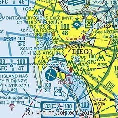
| Sectional chart |
|---|
|
CAUTION: Diagram may not be current
 Download PDF
of official airport diagram from the FAA
| Airport distance calculator |
|---|
|
|
| Sunrise and sunset |
|---|
|
Times for 03-Oct-2025
| | Local
(UTC-7) | | Zulu
(UTC) |
|---|
| Morning civil twilight | | 06:21 | | 13:21 |
| Sunrise | | 06:45 | | 13:45 |
| Sunset | | 18:30 | | 01:30 |
| Evening civil twilight | | 18:55 | | 01:55 |
|
| Current date and time |
|---|
| Zulu (UTC) | 03-Oct-2025 15:15:14 |
|---|
| Local (UTC-7) | 03-Oct-2025 08:15:14 |
|---|
|
| METAR |
|---|
| KSAN | 031451Z 08004KT 10SM BKN027 19/14 A3002 RMK AO2 SLP165 T01940144 53008
|
KNZY
2nm SW | 031452Z 00000KT 10SM BKN027 19/15 A3000 RMK AO2 SLP157 T01940150 53008
|
KMYF
6nm NE | 031453Z 00000KT 10SM OVC024 18/14 A3001 RMK AO2 SLP159 T01780139 53008
|
KNKX
8nm N | 031455Z AUTO 09004KT 10SM OVC026 18/14 A3001 RMK AO2 SLP157 T01830144 53008
|
KNRS
11nm S | 031453Z 07005KT 10SM BKN025 18/16 A3001 RMK AO2 SLP162 T01830156 53006 $
|
KSEE
12nm NE | 031457Z 00000KT 10SM FEW023 17/13 A3002
|
KSDM
13nm SE | 031453Z AUTO 00000KT 10SM OVC022 19/14 A3001 RMK AO2 SLP159 T01890144 53008
|
MMTJ
16nm SE | 031442Z 10003KT 10SM BKN022 18/14 A3004 RMK SLP178 52008 954 8/500 HZY
|
|
| TAF |
|---|
| KSAN | 031232Z 0313/0418 VRB04KT P6SM SCT025 TEMPO 0313/0317 BKN025 FM031900 30012G18KT P6SM FEW030 FM040200 30008KT P6SM SCT025 SCT035 TEMPO 0402/0406 BKN025 FM040600 VRB04KT P6SM SCT025
|
KNZY
2nm SW | 0307/0407 VRB06KT 8000 BR BKN025 QNH2997INS TEMPO 0308/0314 9999 SCT025 BECMG 0318/0320 30012KT 9999 NSW FEW020 QNH2996INS FM030600 VRB06KT 9999 BKN015 QNH2995INS TX23/0322Z TN19/0314Z FS30217
|
KNKX
8nm N | 0309/0409 VRB05KT 9999 OVC010 QNH3000INS BECMG 0316/0318 26006KT 9999 SCT030 QNH2998INS FM032000 27010KT 9999 FEW030 QNH2998INS BECMG 0320/0322 27011G21KT 9999 SKC QNH2994INS BECMG 0301/0303 28007KT 9999 FEW010 QNH2996INS TX24/0421Z TN17/0312Z
|
MMTJ
16nm SE | 031150Z 0312/0412 26005KT P6SM SKC TX24/0320Z TN16/0318Z TEMPO 0312/0316 4SM HZ BKN008 FM031800 26012KT P6SM SCT250 FM040600 26005KT P6SM BKN012 FM040800 00000KT 4SM HZ BKN008
|
|
| NOTAMs |
|---|
NOTAMs are issued by the DoD/FAA and will open in a separate window not controlled by AirNav.
|
|


