FAA INFORMATION EFFECTIVE 09 JULY 2026
Location
| FAA Identifier: | SOP |
| Lat/Long: | 35-14-14.7210N 079-23-20.5210W
35-14.245350N 079-23.342017W
35.2374225,-79.3890336
(estimated) |
| Elevation: | 459.3 ft. / 140.0 m (surveyed) |
| Variation: | 08W (2000) |
| From city: | 3 miles N of central business district of the associated city |
| Time zone: | UTC -4 (UTC -5 during Standard Time) |
| Zip code: | 28327 |
Airport Operations
| Airport use: | Open to the public |
| Activation date: | 09/1937 |
| Control tower: | no |
| ARTCC: | WASHINGTON CENTER |
| FSS: | RALEIGH FLIGHT SERVICE STATION |
| NOTAMs facility: | SOP (NOTAM-D service available) |
| Attendance: | 0800-2000 |
| Wind indicator: | lighted |
| Segmented circle: | no |
| Lights: | ACTVT MALSR RWY 05; REIL RWY 23; HIRL RWY 05/23; TWY LGTS - CTAF. PAPI RWY 05 & 23 OPERS CONSLY. |
| Beacon: | white-green (lighted land airport)
Operates sunset to sunrise. |
| Airline operations: | CLSD TO UNSKED AIR CARRIER OPER WITH MORE THAN 30 PASSENGER SEATS; CALL AMGR 910-692-3212. |
Airport Communications
| CTAF/UNICOM: | 123.05 |
| WX AWOS-3PT: | 127.575 (910-692-4287) |
| FAYETTEVILLE APPROACH: | 127.8 |
| FAYETTEVILLE DEPARTURE: | 127.8 |
| CLEARANCE DELIVERY: | 127.0 |
| WX ASOS at HFF (13 nm SW): | 141.25 (910-396-7804) |
Nearby radio navigation aids
| VOR radial/distance | | VOR name | | Freq | | Var |
|---|
| SDZr085/9.8 | | SANDHILLS VORTAC | | 111.80 | | 03W |
| FAYr305/29.4 | | FAYETTEVILLE VOR/DME | | 114.85 | | 04W |
| LIBr165/36.1 | | LIBERTY VORTAC | | 113.00 | | 03W |
Airport Services
| Fuel available: | 100LL JET-A+ |
| Parking: | hangars and tiedowns |
| Airframe service: | MAJOR |
| Powerplant service: | MAJOR |
| Bottled oxygen: | HIGH |
| Bulk oxygen: | NONE |
Runway Information
Runway 5/23
| Dimensions: | 6503 x 150 ft. / 1982 x 46 m |
| Surface: | asphalt/grooved, in excellent condition |
| Weight bearing capacity: | | PCN 27 /F/A/X/T | | Single wheel: | 100.0 | | Double wheel: | 162.0 |
|
| Runway edge lights: | high intensity |
| RUNWAY 5 | | RUNWAY 23 |
| Latitude: | 35-13.874613N | | 35-14.616058N |
| Longitude: | 079-23.813713W | | 079-22.870243W |
| Elevation: | 459.3 ft. | | 433.2 ft. |
| Traffic pattern: | left | | left |
| Runway heading: | 054 magnetic, 046 true | | 234 magnetic, 226 true |
| Displaced threshold: | 600 ft. | | 400 ft. |
| Declared distances: | TORA:6502 TODA:6502 ASDA:6102 LDA:5502 | | TORA:6502 TODA:6502 ASDA:6102 LDA:5722 |
| Markings: | precision, in good condition | | precision, in good condition |
| Visual slope indicator: | 4-light PAPI on left (3.00 degrees glide path) | | 4-light PAPI on right (3.00 degrees glide path) |
| Approach lights: | MALSR: 1,400 foot medium intensity approach lighting system with runway alignment indicator lights | | |
| Runway end identifier lights: | | | yes |
| Touchdown point: | yes, no lights | | yes, no lights |
| Instrument approach: | ILS/DME | | |
| Obstructions: | 71 ft. trees, 1740 ft. from runway, 456 ft. right of centerline, 21:1 slope to clear
APCH RATIO 30:1 AT DSPLCD THR 72 FT TREES. | | 38 ft. trees, 987 ft. from runway, 185 ft. left of centerline, 20:1 slope to clear |
Airport Ownership and Management from official FAA records
| Ownership: | Publicly-owned |
| Owner: | COUNTY OF MOORE
P O BOX 905
CARTHAGE, NC 28327
Phone 910-692-3212 |
| Manager: | RICK CLOUTIER
P.O. DRAWER 5809
PINEHURST, NC 28374
Phone 910-692-3212 |
Additional Remarks
| - | NOISE ABATEMENT PROCEDURES IN EFFECT. CTC AMGR 910-692-3212. |
| - | BIRD ACTVTY ON & INVOF ARPT APR-OCT. |
| - | 12 HR PPR FOR JET OPNS CONDUCTED 2300-0600, CTC AMGR 910-692-3212. |
| - | MAINT AVBL. |
| - | FLT TRNG AVBL. |
| - | FOR CD CTC FAYETTEVILLE APCH 910-484-8012. |
| - | FIXED WING AIRCRAFT OPERATIONS NOT AUTHORIZED FROM ANY GRASS/TURF SURFACE. |
Instrument Procedures
NOTE: All procedures below are presented as PDF files. If you need a reader for these files, you should download the free Adobe Reader.NOT FOR NAVIGATION. Please procure official charts for flight.
FAA instrument procedures published for use from 09 July 2026 at 0901Z to 06 August 2026 at 0900Z.
IAPs - Instrument Approach Procedures |
|---|
| ILS Y OR LOC Y RWY 05 | |
download (232KB) |
| ILS Z OR LOC Z RWY 05 | |
download (224KB) |
| RNAV (GPS) RWY 05 | |
download (268KB) |
| RNAV (GPS) RWY 23 | |
download (234KB) |
| NOTE: Special Alternate Minimums apply | |
download (64KB) |
| NOTE: Special Take-Off Minimums/Departure Procedures apply | |
download (214KB) |
Other nearby airports with instrument procedures:
KHFF - Mackall Army Airfield (13 nm SW)
5W4 - P K Airpark (16 nm SE)
KPOB - Pope Army Airfield (19 nm E)
43A - Montgomery County Airport (22 nm NW)
KFBG - Simmons Army Airfield (23 nm E)
|
|

Road maps at:
MapQuest
Bing
Google
| Aerial photo |
|---|
WARNING: Photo may not be current or correct
 Taken early February 2014
looking east.
Taken early February 2014
looking east.
Do you have a better or more recent aerial photo of Moore County Airport that you would like to share? If so, please send us your photo.
|
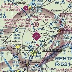
| Sectional chart |
|---|
|
| Airport distance calculator |
|---|
|
|
| Sunrise and sunset |
|---|
|
Times for 10-Jul-2026
| | Local
(UTC-4) | | Zulu
(UTC) |
|---|
| Morning civil twilight | | 05:43 | | 09:43 |
| Sunrise | | 06:12 | | 10:12 |
| Sunset | | 20:34 | | 00:34 |
| Evening civil twilight | | 21:03 | | 01:03 |
|
| Current date and time |
|---|
| Zulu (UTC) | 10-Jul-2026 13:35:46 |
|---|
| Local (UTC-4) | 10-Jul-2026 09:35:46 |
|---|
|
| METAR |
|---|
| KSOP | 101256Z AUTO 26005KT 10SM CLR 29/22 A3003 RMK AO2 SLP167 T02890222 $
|
KHFF
14nm S | 101255Z AUTO 28006KT 10SM CLR 28/22 A2999 RMK AO2 SLP153 T02830215 $
|
KPOB
19nm E | 101255Z AUTO 26009KT 10SM CLR 29/21 A2999 RMK AO2 SLP155 T02900212 $
|
|
| TAF |
|---|
KPOB
19nm E | 100100Z 1001/1107 23008KT 9999 VCSH BKN070 QNH2989INS BECMG 1002/1003 23008KT 9999 NSW SCT070 QNH2991INS BECMG 1013/1014 25010KT 9999 FEW050 QNH2993INS BECMG 1016/1017 25013G21KT 9999 BKN060 BKN080 QNH2984INS BECMG 1020/1021 26013G21KT 9999 VCTS BKN060 BKN100 QNH2984INS BECMG 1100/1101 26006KT 9999 NSW FEW060 BKN130 QNH2989INS TX37/1020Z TN25/1010Z LAST NO AMDS AFT 1002 NEXT 1017
|
|
| NOTAMs |
|---|
NOTAMs are issued by the DoD/FAA and will open in a separate window not controlled by AirNav.
|
|


