FAA INFORMATION EFFECTIVE 14 MAY 2026
Location
| FAA Identifier: | SZT |
| Lat/Long: | 48-17-58.3000N 116-33-36.5000W
48-17.971667N 116-33.608333W
48.2995278,-116.5601389
(estimated) |
| Elevation: | 2131 ft. / 649.5 m (surveyed) |
| Variation: | 14E (2020) |
| From city: | 2 miles N of SANDPOINT, ID |
| Time zone: | UTC -7 (UTC -8 during Standard Time) |
| Zip code: | 83864 |
Airport Operations
| Airport use: | Open to the public |
| Activation date: | 04/1940 |
| Control tower: | no |
| ARTCC: | SEATTLE CENTER |
| FSS: | BOISE FLIGHT SERVICE STATION |
| NOTAMs facility: | SZT (NOTAM-D service available) |
| Attendance: | SUMMER 0700-1700, WINTER 0800-1700 |
| Wind indicator: | lighted |
| Segmented circle: | yes |
| Lights: | ACTVT REIL RWY 02 & 20; MIRL 02/20 - CTAF. PAPI RWY 02 & 20 OPR CONSLY. |
| Beacon: | white-green (lighted land airport)
Operates sunset to sunrise. |
Airport Communications
| CTAF/UNICOM: | 122.7 |
| WX AWOS-2: | 135.425 (208-263-3074) |
- APCH/DEP CTL SVC PRVDD BY SEATTLE ARTCC (ZSE) ON FREQS 123.95/290.55 (LAKESIDE RCAG.)
Nearby radio navigation aids
| VOR radial/distance | | VOR name | | Freq | | Var |
|---|
| COEr359/33.2 | | COEUR D'ALENE VOR/DME | | 108.80 | | 19E |
| NDB name | | Hdg/Dist | | Freq | | Var | | ID |
|---|
| SANDPOE | | at field | | 264 | | 14E | | SZT | ... --.. - |
| DEER PARK | | 044/40.0 | | 365 | | 16E | | DPY | -.. .--. -.-- |
Airport Services
| Fuel available: | 100LL JET-A |
| Parking: | hangars and tiedowns |
| Airframe service: | MAJOR |
| Powerplant service: | MAJOR |
| Bottled oxygen: | HIGH/LOW |
| Bulk oxygen: | NONE |
Runway Information
Runway 2/20
| Dimensions: | 5501 x 75 ft. / 1677 x 23 m |
| Surface: | asphalt, in good condition |
| Weight bearing capacity: | |
| Runway edge lights: | medium intensity |
| RUNWAY 2 | | RUNWAY 20 |
| Latitude: | 48-17.589518N | | 48-18.355357N |
| Longitude: | 116-33.969337W | | 116-33.247523W |
| Elevation: | 2128.3 ft. | | 2128.9 ft. |
| Traffic pattern: | left | | left |
| Runway heading: | 018 magnetic, 032 true | | 198 magnetic, 212 true |
| Markings: | nonprecision, in good condition | | nonprecision, in good condition |
| Visual slope indicator: | 2-light PAPI on left (3.75 degrees glide path) | | 2-light PAPI on left (3.75 degrees glide path) |
| Runway end identifier lights: | yes | | yes |
| Touchdown point: | yes, no lights | | yes, no lights |
| Instrument approach: | LOC/DME | | |
| Obstructions: | 60 ft. trees, 850 ft. from runway, 100 ft. right of centerline, 10:1 slope to clear | | 90 ft. trees, 610 ft. from runway, 280 ft. right of centerline, 4:1 slope to clear |
Airport Ownership and Management from official FAA records
| Ownership: | Publicly-owned |
| Owner: | BONNER COUNTY
1500 HWY 2
SANDPOINT, ID 83864
Phone 208-265-1438 |
| Manager: | DAVE SCHUCK
1500 HWY 2 SUITE 308
SANDPOINT, ID 83864
Phone 208-265-2266 |
Additional Remarks
| - | ADDNL OBSTN 23 FT RR AT 740 FT ON CNTRLN, 85 FT TREES AT 2650 FT ON CNTRLN. |
| - | WILDLIFE INVOF ARPT. |
| - | FOR CD CTC SEATTLE ARTCC AT 253-351-3694. |
| - | COLD TEMPERATURE AIRPORT. ALTITUDE CORRECTION REQUIRED AT OR BELOW -16C. |
Instrument Procedures
NOTE: All procedures below are presented as PDF files. If you need a reader for these files, you should download the free Adobe Reader.NOT FOR NAVIGATION. Please procure official charts for flight.
FAA instrument procedures published for use from 14 May 2026 at 0901Z to 11 June 2026 at 0900Z.
IAPs - Instrument Approach Procedures |
|---|
| RNAV (GPS) Y RWY 02 **CHANGED** | |
download (488KB) |
| RNAV (GPS) Y RWY 20 **CHANGED** | |
download (405KB) |
| RNAV (GPS) Z RWY 02 **CHANGED** | |
download (500KB) |
| RNAV (GPS) Z RWY 20 **CHANGED** | |
download (413KB) |
| RNAV (GPS)-B **CHANGED** | |
download (404KB) |
| NOTE: Special Alternate Minimums apply | |
download (212KB) |
| NOTE: Special Take-Off Minimums/Departure Procedures apply | |
download (341KB) |
Other nearby airports with instrument procedures:
65S - Boundary County Airport (28 nm N)
KCOE - Coeur D'Alene Airport (33 nm S)
KDEW - Deer Park Airport (40 nm SW)
S59 - Libby Airport (43 nm E)
KSFF - Felts Field Airport (48 nm SW)
|
|

Road maps at:
MapQuest
Bing
Google
| Aerial photo |
|---|
WARNING: Photo may not be current or correct
 Photo by Mitch Bowers
www.imagewerx.us
Taken in 2018
looking south.
Do you have a better or more recent aerial photo of Sandpoint Airport that you would like to share? If so, please send us your photo.
|
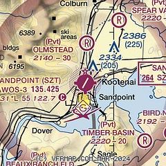
| Sectional chart |
|---|
|
| Airport distance calculator |
|---|
|
|
| Sunrise and sunset |
|---|
|
Times for 02-Jun-2026
| | Local
(UTC-7) | | Zulu
(UTC) |
|---|
| Morning civil twilight | | 04:09 | | 11:09 |
| Sunrise | | 04:50 | | 11:50 |
| Sunset | | 20:39 | | 03:39 |
| Evening civil twilight | | 21:19 | | 04:19 |
|
| Current date and time |
|---|
| Zulu (UTC) | 02-Jun-2026 18:07:53 |
|---|
| Local (UTC-7) | 02-Jun-2026 11:07:53 |
|---|
|
| METAR |
|---|
| KSZT | 021755Z AUTO 10005KT 10SM CLR 18/07 A3015 RMK AO2
|
|
| TAF |
|---|
KCOE
34nm S | 021720Z 0218/0318 02007KT P6SM SCT090 BKN200 FM022000 VRB05KT P6SM BKN060 OVC200 FM030300 06004KT P6SM SCT070 SCT200 FM031400 05007KT P6SM FEW060 SCT200
|
|
| NOTAMs |
|---|
NOTAMs are issued by the DoD/FAA and will open in a separate window not controlled by AirNav.
|
|

