FAA INFORMATION EFFECTIVE 25 DECEMBER 2025
Location
| FAA Identifier: | LYH |
| Lat/Long: | 37-19-31.4000N 079-12-04.4000W
37-19.523333N 079-12.073333W
37.3253889,-79.2012222
(estimated) |
| Elevation: | 938.2 ft. / 286.0 m (surveyed) |
| Variation: | 08W (1995) |
| From city: | 5 miles SW of LYNCHBURG, VA |
| Time zone: | UTC -5 (UTC -4 during Daylight Saving Time) |
| Zip code: | 24502 |
Airport Operations
| Airport use: | Open to the public |
| Activation date: | 08/1937 |
| Control tower: | yes |
| ARTCC: | WASHINGTON CENTER |
| FSS: | LEESBURG FLIGHT SERVICE STATION |
| NOTAMs facility: | LYH (NOTAM-D service available) |
| Attendance: | 0500-2359 |
| Wind indicator: | lighted |
| Segmented circle: | no |
| Lights: | WHEN ATCT CLSD ACTVT MALSR RWY 04; HIRL RWY 04/22; TWY LGTS - CTAF. REIL 17/35; PAPI RWY 17/35; MIRL RWY 17/35 UNAVBL WHEN ATCT CLSD. RWY 04/22 PAPI LGTD 24 HRS. |
| Beacon: | white-green (lighted land airport)
Operates sunset to sunrise. |
| Fire and rescue: | ARFF index A |
| Airline operations: | PPR 12 HRS FOR UNSKED ACR OPNS WITH MORE THAN 30 PSGR SEATS. CALL ARFF 434-582-1157. INDEX "B" COVERAGE PRVDD. |
Airport Communications
| CTAF: | 127.65 |
| UNICOM: | 122.95 |
| ATIS: | 119.8 |
| WX ASOS: | PHONE 434-205-0756 |
| LYNCHBURG GROUND: | 121.9 [0630-2230] |
| LYNCHBURG TOWER: | 127.65 257.8 [0630-2230] |
| ROANOKE APPROACH: | 125.475 ;EAST OF LYH VORTAC 135.0 ;WEST OF LYH VORTAC |
| ROANOKE DEPARTURE: | 125.475 ;EAST OF LYH VORTAC 135.0 ;WEST OF LYH VORTAC |
| EMERG: | 121.5 243.0 |
| IC: | 135.0 ;WEST OF LYH VORTAC |
| WX AWOS-3 at 0V4 (14 nm SE): | 120.575 (434-283-7826) |
Nearby radio navigation aids
| VOR radial/distance | | VOR name | | Freq | | Var |
|---|
| LYHr027/4.6 | | LYNCHBURG VOR/DME | | 109.20 | | 05W |
| MOLr192/34.8 | | MONTEBELLO VOR/DME | | 115.30 | | 05W |
| NDB name | | Hdg/Dist | | Freq | | Var | | ID |
|---|
| BOJAR | | 036/4.3 | | 385 | | 08W | | LY | .-.. -.-- |
| VINTON | | 085/33.3 | | 277 | | 08W | | VIT | ...- .. - |
Airport Services
| Fuel available: | 100LL JET-A |
| Parking: | hangars and tiedowns |
| Airframe service: | MAJOR |
| Powerplant service: | MAJOR |
| Bottled oxygen: | HIGH |
| Bulk oxygen: | NONE |
Runway Information
Runway 4/22
| Dimensions: | 7100 x 150 ft. / 2164 x 46 m |
| Surface: | asphalt/grooved, in good condition |
| Weight bearing capacity: | | Single wheel: | 90.0 | | Double wheel: | 108.0 | | Double tandem: | 170.0 |
|
| Runway edge lights: | high intensity |
| RUNWAY 4 | | RUNWAY 22 |
| Latitude: | 37-18.882992N | | 37-19.917800N |
| Longitude: | 079-12.478148W | | 079-11.794793W |
| Elevation: | 892.8 ft. | | 938.0 ft. |
| Traffic pattern: | left | | left |
| Runway heading: | 036 magnetic, 028 true | | 216 magnetic, 208 true |
| Declared distances: | TORA:7100 TODA:7100 ASDA:6800 LDA:6800 | | TORA:7100 TODA:7100 ASDA:7100 LDA:7100 |
| Markings: | precision, in good condition | | nonprecision, in good condition |
| Visual slope indicator: | 4-light PAPI on left (3.00 degrees glide path) | | 4-light PAPI on left (3.00 degrees glide path) |
| RVR equipment: | touchdown | | rollout |
| Approach lights: | MALSR: 1,400 foot medium intensity approach lighting system with runway alignment indicator lights | | |
| Runway end identifier lights: | | | yes |
| Touchdown point: | yes, no lights | | yes, no lights |
| Instrument approach: | ILS | | |
Runway 17/35
| Dimensions: | 3386 x 75 ft. / 1032 x 23 m |
| Surface: | asphalt, in good condition |
| Weight bearing capacity: | | Single wheel: | 25.0 | | Double wheel: | 35.0 | | Double tandem: | 55.0 |
|
| Runway edge lights: | medium intensity |
| Operational restrictions: | RWY 17/35 NOT AVBL FOR PART 121/PART 380 OPS WITH SKED PAX CARRYING OPS MORE THAN 9 PAX SEATS AND NON-SKED PAX CARRYING OPS MORE THAN 30 PAX SEATS. RY 17/35 300 FT OVERRUN EACH END. |
| RUNWAY 17 | | RUNWAY 35 |
| Latitude: | 37-20.045908N | | 37-19.518010N |
| Longitude: | 079-12.056185W | | 079-11.829943W |
| Elevation: | 921.5 ft. | | 921.2 ft. |
| Traffic pattern: | left | | left |
| Runway heading: | 169 magnetic, 161 true | | 349 magnetic, 341 true |
| Declared distances: | TORA:3386 TODA:3386 ASDA:3386 LDA:3386 | | TORA:3386 TODA:3386 ASDA:3386 LDA:3386 |
| Markings: | nonprecision, in good condition | | nonprecision, in good condition |
| Visual slope indicator: | 2-light PAPI on left (4.00 degrees glide path) | | 2-light PAPI on left (4.00 degrees glide path) |
| Runway end identifier lights: | yes | | yes |
| Touchdown point: | yes, no lights | | yes, no lights |
Airport Ownership and Management from official FAA records
| Ownership: | Publicly-owned |
| Owner: | CITY OF LYNCHBURG
350 TERMINAL DRIVE, SUITE 100
LYNCHBURG, VA 24502
Phone 434-455-6090 |
| Manager: | CEDRIC SIMON
350 TERMINAL DRIVE, SUITE 100
LYNCHBURG, VA 24502
Phone 434-455-6090 |
Additional Remarks
| A39-04/22 | PCR VALUE: 500/F/D/X/T |
| - | TWY G UNCONTROLLED-NOT VISIBLE FROM ATCT. |
| - | BIRDS AND OTHER WILDLIFE ON & INVOF ARPT. |
| - | RY 17/35 PPR FOR ACFT OVER 12500 LBS. |
| - | TWY G CLSD TO AIR CARRIER AND ACFT OVER 12500 LBS. |
| - | ALL SURFACES WORK IN PROGRESS MOWING/MAINTENANCE. |
| - | EXTSV FLT TRNG ON AND INVOF ARPT. |
| - | FOR CD WHEN ATCT CLSD CTC ROANOKE APCH AT 540-563-1307. |
Instrument Procedures
NOTE: All procedures below are presented as PDF files. If you need a reader for these files, you should download the free Adobe Reader.NOT FOR NAVIGATION. Please procure official charts for flight.
FAA instrument procedures published for use from 25 December 2025 at 0901z to 22 January 2026 at 0900z.
IAPs - Instrument Approach Procedures |
|---|
| ILS OR LOC RWY 04 **CHANGED** | |
download (304KB) |
| RNAV (GPS) RWY 04 **CHANGED** | |
download (249KB) |
| RNAV (GPS) RWY 17 **CHANGED** | |
download (198KB) |
| RNAV (GPS) RWY 22 **CHANGED** | |
download (261KB) |
| RNAV (GPS) RWY 35 **CHANGED** | |
download (203KB) |
| NOTE: Special Alternate Minimums apply | |
download (167KB) |
Departure Procedures |
|---|
| HURTT FIVE (RNAV) | |
download (138KB) |
| LIBRT THREE (RNAV) | |
download (137KB) |
| NOTE: Special Take-Off Minimums/Departure Procedures apply | |
download (357KB) |
Other nearby airports with instrument procedures:
W24 - Falwell Airport (5 nm NE)
W90 - New London Airport (7 nm SW)
0V4 - Brookneal/Campbell County Airport (14 nm SE)
W91 - Smith Mountain Lake Airport (23 nm SW)
KFVX - Farmville Regional Airport (36 nm E)
|
|

Road maps at:
MapQuest
Bing
Google
| Aerial photo |
|---|
WARNING: Photo may not be current or correct
 Photo by Christian Eberle
Taken in November 2007
Photo by Christian Eberle
Taken in November 2007
Do you have a better or more recent aerial photo of Lynchburg Regional Airport/Preston Glenn Field that you would like to share? If so, please send us your photo.
|
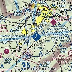
| Sectional chart |
|---|
|
 Download PDF
of official airport diagram from the FAA
| Airport distance calculator |
|---|
|
|
| Sunrise and sunset |
|---|
|
Times for 12-Jan-2026
| | Local
(UTC-5) | | Zulu
(UTC) |
|---|
| Morning civil twilight | | 07:03 | | 12:03 |
| Sunrise | | 07:32 | | 12:32 |
| Sunset | | 17:19 | | 22:19 |
| Evening civil twilight | | 17:47 | | 22:47 |
|
| Current date and time |
|---|
| Zulu (UTC) | 13-Jan-2026 00:13:00 |
|---|
| Local (UTC-5) | 12-Jan-2026 19:13:00 |
|---|
|
| METAR |
|---|
| KLYH | 122354Z 25003KT 10SM CLR 04/M08 A3023 RMK AO2 SLP243 T00441083 10089 20011 56001
|
K0V4
14nm SE | 122355Z AUTO 19006KT 10SM CLR 02/M05 A3024 RMK AO1
|
|
| TAF |
|---|
| KLYH | 121720Z 1218/1318 22004KT P6SM SKC FM131000 23003KT P6SM SCT250
|
|
| NOTAMs |
|---|
NOTAMs are issued by the DoD/FAA and will open in a separate window not controlled by AirNav.
|
|


