FAA INFORMATION EFFECTIVE 09 JULY 2026
Location
| FAA Identifier: | MQS |
| Lat/Long: | 39-58-44.3000N 075-51-55.7000W
39-58.738333N 075-51.928333W
39.9789722,-75.8654722
(estimated) |
| Elevation: | 660.2 ft. / 201.2 m (surveyed) |
| Variation: | 11W (1990) |
| From city: | 2 miles W of COATESVILLE, PA |
| Time zone: | UTC -4 (UTC -5 during Standard Time) |
| Zip code: | 19320 |
Airport Operations
| Airport use: | Open to the public |
| Activation date: | 09/1937 |
| Control tower: | no |
| ARTCC: | NEW YORK CENTER |
| FSS: | WILLIAMSPORT FLIGHT SERVICE STATION |
| NOTAMs facility: | IPT (NOTAM-D service available) |
| Attendance: | 0600-2200
FOR SVC AFTER HRS CNT 610-384-9000 |
| Wind indicator: | lighted |
| Segmented circle: | no |
| Lights: | DUSK-DAWN. ACTVT REIL RWY 11/29; HIRL RWY 11/29 - CTAF. |
| Beacon: | white-green (lighted land airport)
Operates sunset to sunrise. |
Airport Communications
| CTAF/UNICOM: | 122.7 |
| WX AWOS-3: | 126.25 (610-384-6132) |
| PHILADELPHIA APPROACH: | 124.35 |
| PHILADELPHIA DEPARTURE: | 124.35 |
| CLEARANCE DELIVERY: | 125.6 |
| WX AWOS-3T at OQN (13 nm E): | 121.4 ((610) 692-6190) |
Nearby radio navigation aids
| VOR radial/distance | | VOR name | | Freq | | Var |
|---|
| MXEr301/9.7 | | MODENA VORTAC | | 113.20 | | 09W |
| PTWr233/20.2 | | POTTSTOWN VORTAC | | 116.50 | | 09W |
| LRPr122/21.3 | | LANCASTER VOR/DME | | 117.30 | | 09W |
| DQOr337/21.6 | | DUPONT VORTAC | | 114.00 | | 10W |
| OODr318/33.1 | | WOODSTOWN VORTAC | | 112.80 | | 10W |
| ETXr202/37.1 | | EAST TEXAS VOR/DME | | 110.20 | | 09W |
Airport Services
| Fuel available: | 100LL JET-A |
| Parking: | hangars and tiedowns |
| Airframe service: | MAJOR |
| Powerplant service: | MAJOR |
| Bottled oxygen: | HIGH/LOW |
| Bulk oxygen: | HIGH/LOW |
Runway Information
Runway 11/29
| Dimensions: | 5400 x 100 ft. / 1646 x 30 m |
| Surface: | asphalt/grooved, in good condition |
| Weight bearing capacity: | | Single wheel: | 30.0 | | Double wheel: | 48.0 |
|
| Runway edge lights: | high intensity |
| RUNWAY 11 | | RUNWAY 29 |
| Latitude: | 39-58.827377N | | 39-58.647960N |
| Longitude: | 075-52.494212W | | 075-51.361928W |
| Elevation: | 638.4 ft. | | 660.0 ft. |
| Traffic pattern: | left | | left |
| Runway heading: | 113 magnetic, 102 true | | 293 magnetic, 282 true |
| Markings: | nonprecision, in good condition | | precision, in good condition |
| Visual slope indicator: | 4-light PAPI on right (3.20 degrees glide path)
UNUSBL BYD 6 DEG LEFT OF CRS. | | 4-light PAPI on left (3.00 degrees glide path) |
| Runway end identifier lights: | yes | | yes |
| Touchdown point: | yes, no lights | | yes, no lights |
| Instrument approach: | | | ILS |
| Obstructions: | 56 ft. tree, lighted, 777 ft. from runway, 504 ft. left of centerline, 10:1 slope to clear | | 14 ft. trees, 238 ft. from runway, 467 ft. left of centerline, 2:1 slope to clear |
Airport Ownership and Management from official FAA records
| Ownership: | Publicly-owned |
| Owner: | CHESTER CO ARPT AUTH
1 EARHART DR SUITE 2
COATESVILLE, PA 19320
Phone 610-383-6057 |
| Manager: | CONNOR LAPPS
1 EARHART DR SUITE 2
COATESVILLE, PA 19320
Phone 610-802-2291 |
Additional Remarks
| - | MIGRATORY BIRDS & DEER ON & INVOF ARPT. |
| - | FOR CD CTC PHILADELPHIA APCH AT 800-354-9884. |
| - | NOISE ABATEMENT PROC IN EFFECT, CTC AMGR CELL. |
| - | +164 FT WATER TWR 1343 FT FM RY 11 THR 1842 FT R MKD WITH STROBE LGT DALGT HRS; STD OBSTN LGT NGT HRS. |
| - | HELICOPTER OPS INVOF ARPT SOUTH AND SOUTHWEST OF RY 11 THLD. |
| - | HELICOPTER TRAFFIC REQUESTED TO LAND AND TKOF FM RY ONLY. HELICOPTER HOVER TAXIING, TKOFS, & LNDGS PROHIBITED FM TWY ALPHA. |
| - | HOVER TAXI ALONG TXY ALPHA PROHIBITED. WHEEL TAXI ON TXY OR HOVER FM RY TO RAMP SIDE PARKING SPOT BY CROSSING PERPENDICULAR TO ALPHA. |
Instrument Procedures
NOTE: All procedures below are presented as PDF files. If you need a reader for these files, you should download the free Adobe Reader.NOT FOR NAVIGATION. Please procure official charts for flight.
FAA instrument procedures published for use from 09 July 2026 at 0901Z to 06 August 2026 at 0900Z.
STARs - Standard Terminal Arrivals |
|---|
| BUNTS THREE **NEW** | |
download (154KB) |
| JIIMS FOUR (RNAV) **NEW** | |
download (351KB) |
| PAATS FOUR (RNAV) **NEW** | |
2 pages:
[1] [2] (487KB) |
IAPs - Instrument Approach Procedures |
|---|
| ILS OR LOC RWY 29 **CHANGED** | |
download (207KB) |
| RNAV (GPS) RWY 11 **CHANGED** | |
download (219KB) |
| RNAV (GPS) RWY 29 **CHANGED** | |
download (214KB) |
| NOTE: Special Alternate Minimums apply | |
download (123KB) |
| NOTE: Special Take-Off Minimums/Departure Procedures apply | |
download (149KB) |
Other nearby airports with instrument procedures:
N57 - New Garden Airport (10 nm SE)
KOQN - Brandywine Regional Airport (13 nm E)
N47 - Pottstown Municipal Airport (19 nm NE)
KPTW - Heritage Field Airport (21 nm NE)
KLNS - Lancaster Airport (21 nm NW)
|
|

Road maps at:
MapQuest
Bing
Google
| Aerial photo |
|---|
WARNING: Photo may not be current or correct
 Photo by David Newcomer
Photo taken 14-Mar-2020
from 3,500' altitude looking east.
Photo by David Newcomer
Photo taken 14-Mar-2020
from 3,500' altitude looking east.
Do you have a better or more recent aerial photo of Chester County G O Carlson Airport that you would like to share? If so, please send us your photo.
|
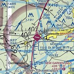
| Sectional chart |
|---|
|
| Airport distance calculator |
|---|
|
|
| Sunrise and sunset |
|---|
|
Times for 14-Jul-2026
| | Local
(UTC-4) | | Zulu
(UTC) |
|---|
| Morning civil twilight | | 05:16 | | 09:16 |
| Sunrise | | 05:47 | | 09:47 |
| Sunset | | 20:31 | | 00:31 |
| Evening civil twilight | | 21:03 | | 01:03 |
|
| Current date and time |
|---|
| Zulu (UTC) | 14-Jul-2026 15:06:01 |
|---|
| Local (UTC-4) | 14-Jul-2026 11:06:01 |
|---|
|
| METAR |
|---|
| KMQS | 141455Z AUTO 29008KT 10SM CLR 28/20 A3015 RMK AO2 T02800201 51002 $
|
KOQN
13nm E | 141455Z AUTO 21004KT 10SM CLR 28/18 A3016 RMK AO2
|
|
| TAF |
|---|
KLNS
22nm NW | 141120Z 1412/1512 00000KT P6SM FEW250 FM141400 28009KT P6SM FEW250 FM150500 27004KT P6SM FEW250
|
KILG
22nm SE | 141120Z 1412/1512 22005KT P6SM FEW300 FM141300 25008KT P6SM SCT300 FM141600 24011KT P6SM BKN300 FM150000 22010KT P6SM SCT300 FM150700 26008KT P6SM SCT300
|
KRDG
24nm N | 141120Z 1412/1512 22003KT P6SM SCT300 FM141300 26008KT P6SM SCT300 FM141600 25012KT P6SM BKN300 FM150000 25007KT P6SM SCT300
|
|
| NOTAMs |
|---|
NOTAMs are issued by the DoD/FAA and will open in a separate window not controlled by AirNav.
|
|

