FAA INFORMATION EFFECTIVE 27 NOVEMBER 2025
Location
| FAA Identifier: | N57 |
| Lat/Long: | 39-49-49.8450N 075-46-11.1130W
39-49.830750N 075-46.185217W
39.8305125,-75.7697536
(estimated) |
| Elevation: | 435.2 ft. / 132.6 m (surveyed) |
| Variation: | 09W (1965) |
| From city: | 1 mile W of TOUGHKENAMON, PA |
| Time zone: | UTC -5 (UTC -4 during Daylight Saving Time) |
| Zip code: | 19311 |
Airport Operations
| Airport use: | Open to the public |
| Activation date: | 01/1968 |
| Control tower: | no |
| ARTCC: | NEW YORK CENTER |
| FSS: | WILLIAMSPORT FLIGHT SERVICE STATION |
| NOTAMs facility: | IPT (NOTAM-D service available) |
| Attendance: | 0800 - 1700 |
| Wind indicator: | lighted |
| Segmented circle: | no |
| Lights: | ACTVT MIRL RWY 06/24 - CTAF. |
| Beacon: | white-green (lighted land airport)
Operates sunset to sunrise. |
| Landing fee: | yes |
Airport Communications
| CTAF/UNICOM: | 123.05 |
| PHILADELPHIA APPROACH: | 124.35 |
| PHILADELPHIA DEPARTURE: | 124.35 |
| CLEARANCE DELIVERY: | 125.6 |
| WX AWOS-3 at MQS (10 nm NW): | 126.25 (610-384-6132) |
| WX ASOS at ILG (12 nm SE): | 123.95 (302-217-3317) |
| WX AWOS-3T at OQN (13 nm NE): | 121.4 ((610) 692-6190) |
| WX AWOS-3 at EVY (19 nm S): | 132.325 (302-378-2063) |
Nearby radio navigation aids
| VOR radial/distance | | VOR name | | Freq | | Var |
|---|
| MXEr230/7.0 | | MODENA VORTAC | | 113.20 | | 09W |
| DQOr331/11.8 | | DUPONT VORTAC | | 114.00 | | 10W |
| OODr308/24.5 | | WOODSTOWN VORTAC | | 112.80 | | 10W |
| PTWr211/25.4 | | POTTSTOWN VORTAC | | 116.50 | | 09W |
| LRPr135/29.6 | | LANCASTER VOR/DME | | 117.30 | | 09W |
| ENOr351/37.8 | | SMYRNA VORTAC | | 111.40 | | 09W |
| NDB name | | Hdg/Dist | | Freq | | Var | | ID |
|---|
| RAINBOW | | 321/38.4 | | 363 | | 11W | | RNB | .-. -. -... |
Airport Services
| Fuel available: | 100LL |
| Parking: | hangars and tiedowns |
| Airframe service: | MAJOR |
| Powerplant service: | MAJOR |
| Bottled oxygen: | NONE |
| Bulk oxygen: | NONE |
Runway Information
Runway 6/24
| Dimensions: | 3693 x 60 ft. / 1126 x 18 m |
| Surface: | asphalt, in excellent condition
TURF SFC SOUTH OF RWY FOR GLIDER RECOVERY ONLY. |
| Runway edge lights: | medium intensity |
| RUNWAY 6 | | RUNWAY 24 |
| Latitude: | 39-49.618460N | | 39-50.043043N |
| Longitude: | 075-46.467663W | | 075-45.902738W |
| Elevation: | 433.4 ft. | | 429.5 ft. |
| Traffic pattern: | left | | left |
| Runway heading: | 055 magnetic, 046 true | | 235 magnetic, 226 true |
| Markings: | nonprecision, in good condition | | nonprecision, in good condition |
| Touchdown point: | yes, no lights | | yes, no lights |
| Obstructions: | 62 ft. trees, 248 ft. from runway, 239 ft. left of centerline
13 FT TREES, 183 FT FROM RWY END & 149 FT RIGHT. | | 15 ft. trees, 307 ft. from runway, 177 ft. left of centerline, 7:1 slope to clear |
Airport Ownership and Management from official FAA records
| Ownership: | Publicly-owned |
| Owner: | NEW GARDEN TOWNSHIP
TOWNSHIP MANAGER, 299 STARR RD.
LANDENBURG, PA 19350
Phone 610-268-2915 |
| Manager: | JONATHAN MARTIN
1235 NEWARK ROAD
TOUGHKENAMON, PA 19374
Phone 610-268-2619 |
Additional Remarks
| - | RWY 06 NOISE ABATEMENT CLIMB TO 1200 FT MSL BFR TURNING CROSSWIND. |
| - | FOR ASST AFTER HRS CTC 610-476-1702 |
| - | DEER AND OTHER WILDLIFE ON AND INVOF ARPT. |
| - | OVNGT PRKG FEE. |
| - | FOR CD CTC PHILADELPHIA APCH AT 800-354-9884. |
Instrument Procedures
NOTE: All procedures below are presented as PDF files. If you need a reader for these files, you should download the free Adobe Reader.NOT FOR NAVIGATION. Please procure official charts for flight.
FAA instrument procedures published for use from 27 November 2025 at 0901Z to 25 December 2025 at 0900Z.
IAPs - Instrument Approach Procedures |
|---|
| RNAV (GPS) RWY 06 | |
download (194KB) |
| RNAV (GPS) RWY 24 | |
download (185KB) |
| NOTE: Special Take-Off Minimums/Departure Procedures apply | |
download (432KB) |
Other nearby airports with instrument procedures:
KMQS - Chester County G O Carlson Airport (10 nm NW)
KILG - New Castle Airport (12 nm SE)
KOQN - Brandywine Regional Airport (13 nm NE)
58M - Claremont Airport (16 nm S)
KEVY - Summit Airport (19 nm S)
|
|

Road maps at:
MapQuest
Bing
Google
| Aerial photo |
|---|
WARNING: Photo may not be current or correct

Do you have a better or more recent aerial photo of New Garden Airport that you would like to share? If so, please send us your photo.
|
| Sectional chart |
|---|
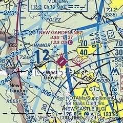
|
| Airport distance calculator |
|---|
|
|
| Sunrise and sunset |
|---|
|
Times for 06-Dec-2025
| | Local
(UTC-5) | | Zulu
(UTC) |
|---|
| Morning civil twilight | | 06:41 | | 11:41 |
| Sunrise | | 07:11 | | 12:11 |
| Sunset | | 16:37 | | 21:37 |
| Evening civil twilight | | 17:07 | | 22:07 |
|
| Current date and time |
|---|
| Zulu (UTC) | 06-Dec-2025 19:09:05 |
|---|
| Local (UTC-5) | 06-Dec-2025 14:09:05 |
|---|
|
| METAR |
|---|
KMQS
10nm NW | 061855Z AUTO 28006KT 9SM CLR 03/M01 A2989 RMK AO2
|
KILG
13nm SE | 061851Z 22006KT 8SM CLR 04/01 A2991 RMK AO2 SLP129 T00440006
|
KOQN
13nm NE | 061855Z AUTO 30005KT 05/M01 A2989 RMK AO2 PWINO
|
|
| TAF |
|---|
KILG
13nm SE | 061728Z 0618/0718 25005KT 5SM BR BKN006 OVC045 FM061900 26005KT P6SM BKN100 FM062100 26005KT P6SM SCT150 FM070300 VRB03KT P6SM FEW200 FM071700 20005KT P6SM BKN200
|
|
| NOTAMs |
|---|
NOTAMs are issued by the DoD/FAA and will open in a separate window not controlled by AirNav.
|
|

