FAA INFORMATION EFFECTIVE 30 OCTOBER 2025
Location
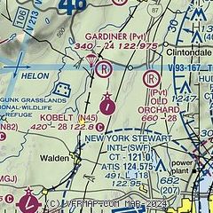
| FAA Identifier: | N45 |
| Lat/Long: | 41-37-27.0000N 074-08-30.0000W
41-37.450000N 074-08.500000W
41.6241667,-74.1416667
(estimated) |
| Elevation: | 420 ft. / 128 m (estimated) |
| Variation: | 13W (1985) |
| From city: | 2 miles NE of WALLKILL, NY |
| Time zone: | UTC -5 (UTC -4 during Daylight Saving Time) |
| Zip code: | 12589 |
Airport Operations
| Airport use: | Open to the public |
| Activation date: | 03/1960 |
| Control tower: | no |
| ARTCC: | NEW YORK CENTER |
| FSS: | NEW YORK FLIGHT SERVICE STATION |
| NOTAMs facility: | ISP (NOTAM-D service available) |
| Attendance: | UNATNDD |
| Wind indicator: | yes |
| Segmented circle: | no |
| Beacon: | white-green (lighted land airport)
Operates sunset to sunrise. |
Airport Communications
| CTAF/UNICOM: | 122.8 |
| WX ASOS at MGJ (9 nm SW): | 119.275 (845-457-1486) |
| WX ASOS at POU (12 nm E): | 126.75 (845-462-0648) |
Nearby radio navigation aids
| VOR radial/distance | | VOR name | | Freq | | Var |
|---|
| IGNr272/14.5 | | KINGSTON VOR/DME | | 117.60 | | 12W |
| HUOr069/24.0 | | HUGUENOT VOR/DME | | 116.10 | | 11W |
| PWLr262/25.8 | | PAWLING VOR/DME | | 114.30 | | 12W |
| CMKr321/32.6 | | CARMEL VOR/DME | | 116.60 | | 12W |
| SAXr039/37.9 | | SPARTA VORTAC | | 115.70 | | 11W |
| NDB name | | Hdg/Dist | | Freq | | Var | | ID |
|---|
| STANWYCK | | 335/7.2 | | 261 | | 12W | | SKU | ... -.- ..- |
| NEELY | | 039/9.2 | | 335 | | 14W | | SW | ... .-- |
Airport Services
| Parking: | tiedowns |
| Bottled oxygen: | NONE |
| Bulk oxygen: | NONE |
Runway Information
Runway 3/21
| Dimensions: | 2864 x 50 ft. / 873 x 15 m |
| Surface: | asphalt, in fair condition
RY 03/21 SLIGHT DEPRESSION IN GRASS AREAS OPPOSITE SOUTH END OF RY. RY CENTER 30 FT IN FAIR CONDITION, OUTSIDE EDGES BEYOND THIS IN POOR CONDITION. |
| Weight bearing capacity: | |
| RUNWAY 3 | | RUNWAY 21 |
| Traffic pattern: | left | | left |
| Obstructions: | 70 ft. trees, 234 ft. from runway, 70 ft. right of centerline
+48 TREES, 77 FT FM RY THLD, 110 FT LEFT OF CTRLN. | | 50 ft. trees, 236 ft. from runway, 84 ft. right of centerline
+50 FT TREES, 194 FT FM RWY THLD, 87 FT RIGHT OF CTRLN;+50 FT TREES, 186 FT FM RWY THLD, 88 FT LEFT OF CTRLN. |
Airport Ownership and Management from official FAA records
| Ownership: | Privately-owned |
| Owner: | WALLKILL AIRPARK, INC
863 PLAINS ROAD
WALLKILL, NY 12589
Phone 845-255-1087 |
| Manager: | WILLIAM RICHARDS & KAY HOIBY-GRIEP
PO BOX 269
GARDINER, NY 12525
Phone 914-548-3028 |
Additional Remarks
| - | ARPT CLSD TO ACFT 13500 LBS & OVER. |
| - | RY 03 HAS ACCESS ROAD 16 FT FM THLD BOTH SIDES. |
| - | DEER ON & INVOF ARPT. |
| - | 18 FT WIDE PARALLEL TWY, STUB CONNECTORS TO RUNWAY BETWEEN ENDS IN POOR CONDITION. |
| - | RY CTR WIDTH OF 30 FT IN GOOD CONDITION, 10 FT OUTSIDE WIDTH ON BOTH SIDES OF CNTRLN IN POOR CONDITION WITH EXTENSIVE CRACKS AND VEGETATION. |
| - | PJE AT ARPT 3.0 NM RADIUS SFC-14500 FT. |
| - | FOR CD CTC NEW YORK APCH AT 516-683-2448. |
Instrument Procedures
There are no published instrument procedures at N45.
Some nearby airports with instrument procedures:
KSWF - New York Stewart International Airport (7 nm S)
KMGJ - Orange County Airport (9 nm SW)
KPOU - Hudson Valley Regional Airport (12 nm E)
N89 - Joseph Y Resnick Airport (12 nm NW)
N82 - Wurtsboro/Sullivan County Airport (14 nm W)
06N - Randall Airport (16 nm SW)
44N - Sky Acres Airport (19 nm E)
|
|

Road maps at:
MapQuest
Bing
Google
| Aerial photo |
|---|
WARNING: Photo may not be current or correct
 Photo by Robert Dant
Do you have a better or more recent aerial photo of Kobelt Airport that you would like to share? If so, please send us your photo.
|
| Sectional chart |
|---|
|
| Airport distance calculator |
|---|
|
|
| Sunrise and sunset |
|---|
|
Times for 23-Nov-2025
| | Local
(UTC-5) | | Zulu
(UTC) |
|---|
| Morning civil twilight | | 06:26 | | 11:26 |
| Sunrise | | 06:56 | | 11:56 |
| Sunset | | 16:30 | | 21:30 |
| Evening civil twilight | | 17:00 | | 22:00 |
|
| Current date and time |
|---|
| Zulu (UTC) | 23-Nov-2025 11:20:20 |
|---|
| Local (UTC-5) | 23-Nov-2025 06:20:20 |
|---|
|
| METAR |
|---|
KSWF
8nm S | 230745Z 00000KT 10SM SKC M04/M05 A3001
|
KMGJ
9nm SW | SuperAWOS
231054Z AUTO 24003KT 10SM CLR M04/M07 A3002 RMK AO2 SLP168 I1000 T10441067 $
|
KPOU
12nm E | 231053Z AUTO 00000KT 10SM CLR M05/M06 A3002 RMK AO2 SLP163 I1000 T10501056
|
|
| TAF |
|---|
KSWF
8nm S | 230830Z 2309/2412 VRB02KT P6SM FEW250 FM231500 25007KT P6SM SCT030 BKN060 TEMPO 2315/2318 BKN030 FM232000 28010G18KT P6SM BKN035 FM240200 29010KT P6SM SCT035 AMD NOT SKED
|
KPOU
12nm E | 230529Z 2306/2406 00000KT P6SM SCT250 FM231400 22007KT P6SM BKN050 FM240200 25005KT P6SM SCT050
|
|
| NOTAMs |
|---|
NOTAMs are issued by the DoD/FAA and will open in a separate window not controlled by AirNav.
|
|

