FAA INFORMATION EFFECTIVE 14 MAY 2026
Location
| FAA Identifier: | SHV |
| Lat/Long: | 32-26-47.4550N 093-49-33.7440W
32-26.790917N 093-49.562400W
32.4465153,-93.8260400
(estimated) |
| Elevation: | 257.6 ft. / 78.5 m (surveyed) |
| Variation: | 02E (2020) |
| From city: | 4 miles SW of SHREVEPORT, LA |
| Time zone: | UTC -5 (UTC -6 during Standard Time) |
| Zip code: | 71109 |
Airport Operations
| Airport use: | Open to the public |
| Activation date: | 08/1952 |
| Control tower: | yes |
| ARTCC: | FORT WORTH CENTER |
| FSS: | DE RIDDER FLIGHT SERVICE STATION |
| NOTAMs facility: | SHV (NOTAM-D service available) |
| Attendance: | CONTINUOUS |
| Wind indicator: | lighted |
| Segmented circle: | no |
| Lights: | SS-SR |
| Beacon: | white-green (lighted land airport)
Operates sunset to sunrise. |
| Landing fee: | no, LNDG FEE FOR ALL COMMERCIAL TFC. |
| Fire and rescue: | ARFF index B |
| International operations: | customs landing rights airport |
Airport Communications
| UNICOM: | 122.95 |
| ATIS: | 128.45 |
| WX ASOS: | 128.45 (318-216-0546) |
| SHREVEPORT GROUND: | 121.175 236.775 |
| SHREVEPORT TOWER: | 121.4 236.775 |
| SHREVEPORT APPROACH: | 119.9 |
| SHREVEPORT DEPARTURE: | 119.9 |
| CLEARANCE DELIVERY: | 124.65 |
| EMERG: | 121.5 243.0 |
| WX ASOS at DTN (7 nm NE): | 118.525 (318-425-7967) |
Nearby radio navigation aids
| VOR radial/distance | | VOR name | | Freq | | Var |
|---|
| EMGr276/12.0 | | ELM GROVE VORTAC | | 116.65 | | 07E |
| EICr175/19.5 | | BELCHER VORTAC | | 117.40 | | 07E |
Airport Services
| Fuel available: | 100LL JET-A |
| Parking: | hangars and tiedowns |
| Airframe service: | MAJOR |
| Powerplant service: | MAJOR |
| Bottled oxygen: | HIGH |
Runway Information
Runway 14/32
| Dimensions: | 8348 x 200 ft. / 2544 x 61 m |
| Surface: | asphalt/grooved, in excellent condition |
| Weight bearing capacity: | | Single wheel: | 120.0 | | Double wheel: | 218.0 | | Double tandem: | 370.0 |
|
| Runway edge lights: | high intensity |
| RUNWAY 14 | | RUNWAY 32 |
| Latitude: | 32-27.230483N | | 32-26.135192N |
| Longitude: | 093-50.092955W | | 093-49.109372W |
| Elevation: | 257.6 ft. | | 222.1 ft. |
| Traffic pattern: | left | | left |
| Runway heading: | 141 magnetic, 143 true | | 321 magnetic, 323 true |
| Displaced threshold: | no | | 373 ft. |
| Declared distances: | TORA:8348 TODA:8348 ASDA:8118 LDA:8118 | | TORA:8348 TODA:8348 ASDA:8348 LDA:7975 |
| Markings: | precision, in good condition | | precision, in good condition |
| Visual slope indicator: | 4-light PAPI on right (3.00 degrees glide path) | | |
| RVR equipment: | touchdown, midfield, rollout | | touchdown, midfield, rollout |
| Approach lights: | ALSF2: standard 2,400 foot high intensity approach lighting system with centerline sequenced flashers (category II or III) | | MALSR: 1,400 foot medium intensity approach lighting system with runway alignment indicator lights |
| Centerline lights: | yes | | yes |
| Touchdown point: | yes, lighted | | yes, no lights |
| Instrument approach: | ILS/DME | | ILS |
| Obstructions: | none | | 32 ft. rr, 920 ft. from runway, 600 ft. right of centerline, 22:1 slope to clear
APCH RATIO 40:1 FM DSPLCD THR. |
Runway 6/24
| Dimensions: | 7003 x 150 ft. / 2135 x 46 m |
| Surface: | asphalt/grooved, in excellent condition |
| Weight bearing capacity: | | Single wheel: | 120.0 | | Double wheel: | 218.0 | | Double tandem: | 370.0 |
|
| Runway edge lights: | medium intensity |
| RUNWAY 6 | | RUNWAY 24 |
| Latitude: | 32-26.638913N | | 32-27.200540N |
| Longitude: | 093-50.111250W | | 093-48.921203W |
| Elevation: | 238.3 ft. | | 228.4 ft. |
| Traffic pattern: | left | | left |
| Runway heading: | 059 magnetic, 061 true | | 239 magnetic, 241 true |
| Declared distances: | TORA:7003 TODA:7003 ASDA:7003 LDA:7003 | | TORA:7003 TODA:7003 ASDA:7003 LDA:7003 |
| Markings: | nonprecision, in good condition | | nonprecision, in good condition |
| Visual slope indicator: | 4-light PAPI on left (3.00 degrees glide path) | | 4-light PAPI on left (3.00 degrees glide path) |
| Runway end identifier lights: | yes | | yes |
| Touchdown point: | yes, no lights | | yes, no lights |
| Instrument approach: | LOC/DME | | |
| Obstructions: | 77 ft. trees, 2000 ft. from runway, 300 ft. right of centerline, 23:1 slope to clear | | 111 ft. trees, 3800 ft. from runway, 32:1 slope to clear |
Airport Ownership and Management from official FAA records
| Ownership: | Publicly-owned |
| Owner: | CITY OF SHREVEPORT
505 TRAVIS STREET
SHREVEPORT, LA 71101
Phone 318-673-5050 |
| Manager: | LARRY BLACKWELL
5103 HOLLYWOOD AVE SUITE 300
SHREVEPORT, LA 71109
Phone 318-673-5370 |
Additional Remarks
| A39-06/24 | PCR VALUE: 542/F/B/X/T |
| A39-14/32 | PCR VALUE: 542/F/B/X/T |
| - | FLIGHT NOTIFICATION SERVICE (ADCUS) AVBL MON-FRI 0800-1700; OTHER TIMES BY APPOINTMENT CALL 318-635-7873 OR 800-973-2867. |
| - | BIRD ACTIVITY INVOF ARPT. |
| - | SFC COND NOT MNT DLY 0700-1100 |
Instrument Procedures
NOTE: All procedures below are presented as PDF files. If you need a reader for these files, you should download the free Adobe Reader.NOT FOR NAVIGATION. Please procure official charts for flight.
FAA instrument procedures published for use from 14 May 2026 at 0901Z to 11 June 2026 at 0900Z.
IAPs - Instrument Approach Procedures |
|---|
| ILS OR LOC RWY 14 | |
download (244KB) |
| ILS OR LOC RWY 32 | |
download (246KB) |
| ILS RWY 14 (CAT II) | |
download (211KB) |
| RNAV (GPS) RWY 06 | |
download (214KB) |
| RNAV (GPS) RWY 14 | |
download (235KB) |
| RNAV (GPS) RWY 24 | |
download (229KB) |
| RNAV (GPS) RWY 32 | |
download (243KB) |
| LOC RWY 06 | |
download (248KB) |
| Radar Approach Procedures available | |
download (184KB) |
| NOTE: Special Alternate Minimums apply | |
download (159KB) |
| NOTE: Special Take-Off Minimums/Departure Procedures apply | |
download |
Other nearby airports with instrument procedures:
KDTN - Shreveport Downtown Airport (7 nm NE)
KBAD - Barksdale Air Force Base (9 nm E)
3F3 - C E 'Rusty' Williams Airport (23 nm S)
KASL - Harrison County Airport (25 nm W)
3F4 - Vivian Airport (27 nm N)
|
|

Road maps at:
MapQuest
Bing
Google
| Aerial photo |
|---|
WARNING: Photo may not be current or correct
 Photo by D. Wilson
Photo taken 28-Jan-2018
looking north from 3500 ft.
Photo by D. Wilson
Photo taken 28-Jan-2018
looking north from 3500 ft.
Do you have a better or more recent aerial photo of Shreveport Regional Airport that you would like to share? If so, please send us your photo.
|
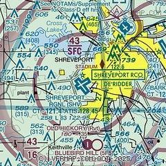
| Sectional chart |
|---|
|
 Download PDF
of official airport diagram from the FAA
| Airport distance calculator |
|---|
|
|
| Sunrise and sunset |
|---|
|
Times for 16-May-2026
| | Local
(UTC-5) | | Zulu
(UTC) |
|---|
| Morning civil twilight | | 05:50 | | 10:50 |
| Sunrise | | 06:17 | | 11:17 |
| Sunset | | 20:06 | | 01:06 |
| Evening civil twilight | | 20:33 | | 01:33 |
|
| Current date and time |
|---|
| Zulu (UTC) | 17-May-2026 03:42:24 |
|---|
| Local (UTC-5) | 16-May-2026 22:42:24 |
|---|
|
| METAR |
|---|
| KSHV | 170256Z 16006KT 10SM CLR 24/19 A2988 RMK SLPNO
|
KDTN
7nm NE | 170253Z AUTO 16010KT 10SM CLR 27/19 A2989 RMK AO2 SLP118 T02670194 53006
|
KBAD
9nm E | 170255Z AUTO 11007KT 10SM CLR 24/20 A2988 RMK AO2 SLP121 T02390196 53007 $
|
|
| TAF |
|---|
| KSHV | 162102Z 1621/1718 18012G19KT P6SM SCT050 FM170000 17009KT P6SM FEW045 SCT150 SCT250 FM170900 17011KT P6SM OVC015 FM171700 16012G19KT P6SM BKN035
|
KBAD
9nm E | 162200Z 1620/1802 15014G22KT 9999 SCT025 QNH2984INS BECMG 1704/1705 14010KT 9999 FEW030 QNH2987INS BECMG 1711/1712 15008KT 9999 OVC007 QNH2990INS BECMG 1714/1715 15014G20KT 9999 OVC015 QNH2980INS BECMG 1717/1718 15014G22KT 9999 BKN020 QNH2980INS BECMG 1721/1722 16015G25KT 9999 BKN050 QNH2981INS TX31/1622Z TN22/1708Z LAST NO AMDS AFT 2200 NEXT 2312
|
|
| NOTAMs |
|---|
NOTAMs are issued by the DoD/FAA and will open in a separate window not controlled by AirNav.
|
|


