FAA INFORMATION EFFECTIVE 27 NOVEMBER 2025
Location
| FAA Identifier: | UNU |
| Lat/Long: | 43-25-35.3000N 088-42-13.9000W
43-25.588333N 088-42.231667W
43.4264722,-88.7038611
(estimated) |
| Elevation: | 934.1 ft. / 284.7 m (surveyed) |
| Variation: | 01W (1995) |
| From city: | 2 miles N of JUNEAU, WI |
| Time zone: | UTC -6 (UTC -5 during Daylight Saving Time) |
| Zip code: | 53039 |
Airport Operations
| Airport use: | Open to the public |
| Activation date: | 07/1979 |
| Control tower: | no |
| ARTCC: | CHICAGO CENTER |
| FSS: | GREEN BAY FLIGHT SERVICE STATION |
| NOTAMs facility: | UNU (NOTAM-D service available) |
| Attendance: | 0700-1900 |
| Wind indicator: | lighted |
| Segmented circle: | yes |
| Lights: | MIRL RWY 08/26 PRESET ON LOW SS-SR; TO INCR INTST & ACTVT MALSF RWY 26; REIL RWY 02, 08 & 20; PAPI RWY 02, 08, 20 & 26; MIRL RWY 02/20; MIRL RWY 08/26 - CTAF. |
| Beacon: | white-green (lighted land airport)
Operates sunset to sunrise. |
Airport Communications
| CTAF/UNICOM: | 122.7 |
| WX AWOS-3: | 120.825 (920-386-5682) |
| MADISON APPROACH: | 119.15 |
| MADISON DEPARTURE: | 119.15 |
| WX AWOS-3 at RYV (15 nm S): | 119.975 (920-261-0734) |
- APCH/DEP SVC PRVDD BY CHICAGO ARTCC ON FREQS 133.3/257.925 (LONE ROCK RCAG) WHEN MADISON APCH CTL CLSD.
Nearby radio navigation aids
| VOR radial/distance | | VOR name | | Freq | | Var |
|---|
| BJBr272/(25.2) | | WEST BEND VOR | | 109.80 | | 01W |
| BAEr313/26.1 | | BADGER VOR/DME | | 116.40 | | 02E |
| MSNr056/32.5 | | MADISON VORTAC | | 108.60 | | 03E |
| OSHr189/34.4 | | OSHKOSH VORTAC | | 116.75 | | 02E |
| NDB name | | Hdg/Dist | | Freq | | Var | | ID |
|---|
| ROCK RIVER | | 005/15.2 | | 371 | | 01W | | RYV | .-. -.-- ...- |
Airport Services
| Fuel available: | 100LL JET-A+ |
| Parking: | hangars and tiedowns |
| Airframe service: | MAJOR |
| Powerplant service: | MAJOR |
| Bottled oxygen: | NONE |
| Bulk oxygen: | NONE |
Runway Information
Runway 8/26
| Dimensions: | 5070 x 100 ft. / 1545 x 30 m |
| Surface: | asphalt, in excellent condition |
| Weight bearing capacity: | |
| Runway edge lights: | medium intensity |
| RUNWAY 8 | | RUNWAY 26 |
| Latitude: | 43-25.495728N | | 43-25.644628N |
| Longitude: | 088-42.995350W | | 088-41.868872W |
| Elevation: | 890.1 ft. | | 934.1 ft. |
| Traffic pattern: | left | | left |
| Runway heading: | 081 magnetic, 080 true | | 261 magnetic, 260 true |
| Markings: | nonprecision, in fair condition | | nonprecision, in good condition |
| Visual slope indicator: | 4-light PAPI on left (3.00 degrees glide path) | | 4-light PAPI on left (3.00 degrees glide path) |
| Approach lights: | | | MALSF: 1,400 foot medium intensity approach lighting system with sequenced flashers |
| Runway end identifier lights: | yes | | |
| Touchdown point: | yes, no lights | | yes, no lights |
| Instrument approach: | | | LOC/DME |
| Obstructions: | 146 ft. trees, 4300 ft. from runway, 400 ft. right of centerline, 28:1 slope to clear | | none |
Runway 2/20
| Dimensions: | 4028 x 75 ft. / 1228 x 23 m |
| Surface: | asphalt, in excellent condition |
| Weight bearing capacity: | |
| Runway edge lights: | medium intensity |
| RUNWAY 2 | | RUNWAY 20 |
| Latitude: | 43-25.296082N | | 43-25.929423N |
| Longitude: | 088-42.112318W | | 088-41.843283W |
| Elevation: | 930.3 ft. | | 932.2 ft. |
| Traffic pattern: | left | | left |
| Runway heading: | 018 magnetic, 017 true | | 198 magnetic, 197 true |
| Markings: | nonprecision, in good condition | | nonprecision, in good condition |
| Visual slope indicator: | 2-light PAPI on left (3.00 degrees glide path) | | 2-light PAPI on left (3.00 degrees glide path) |
| Runway end identifier lights: | yes | | yes |
| Touchdown point: | yes, no lights | | yes, no lights |
Airport Ownership and Management from official FAA records
| Ownership: | Publicly-owned |
| Owner: | DODGE COUNTY
DODGE CO HWY DEPT
JUNEAU, WI 53039
Phone 920-386-3650 |
| Manager: | TOM DAVID
W6491 STATE HIGHWAY 26
JUNEAU, WI 53039
Phone 920-386-2402 |
Additional Remarks
| - | IREG ULTRALIGHT ACTIVITY ON & INVOF ARPT. |
| - | BIRDS ON & INVOF ARPT. |
| - | MOWING OPNS MON-FRI WITH FLASHING LGTS AFT DARK. |
| - | FOR CD CTC MADISON APP/DEP CON AT 608-249-8240. WHEN MADISON APCH CLSD, FOR CD CTC CHICAGO ARTCC AT 630-906-8921. |
Instrument Procedures
NOTE: All procedures below are presented as PDF files. If you need a reader for these files, you should download the free Adobe Reader.NOT FOR NAVIGATION. Please procure official charts for flight.
FAA instrument procedures published for use from 27 November 2025 at 0901Z to 25 December 2025 at 0900Z.
IAPs - Instrument Approach Procedures |
|---|
| RNAV (GPS) RWY 02 | |
download (219KB) |
| RNAV (GPS) RWY 08 | |
download (194KB) |
| RNAV (GPS) RWY 20 | |
download (242KB) |
| RNAV (GPS) RWY 26 | |
download (198KB) |
| NOTE: Special Alternate Minimums apply | |
download (162KB) |
| NOTE: Special Take-Off Minimums/Departure Procedures apply | |
download (478KB) |
Other nearby airports with instrument procedures:
KHXF - Hartford Municipal Airport (14 nm E)
KRYV - Watertown Municipal Airport (15 nm S)
KFLD - Fond Du Lac County Airport (23 nm NE)
KETB - West Bend Municipal Airport (25 nm E)
61C - Fort Atkinson Municipal Airport (28 nm S)
|
|

Road maps at:
MapQuest
Bing
Google
| Aerial photo |
|---|
WARNING: Photo may not be current or correct
 Photo by Larry Jenne from N1428F
Photo taken 09-Apr-2016
looking west.
Photo by Larry Jenne from N1428F
Photo taken 09-Apr-2016
looking west.
Do you have a better or more recent aerial photo of Dodge County Airport that you would like to share? If so, please send us your photo.
|
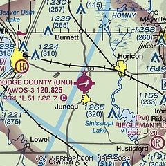
| Sectional chart |
|---|
|
| Airport distance calculator |
|---|
|
|
| Sunrise and sunset |
|---|
|
Times for 09-Dec-2025
| | Local
(UTC-6) | | Zulu
(UTC) |
|---|
| Morning civil twilight | | 06:44 | | 12:44 |
| Sunrise | | 07:17 | | 13:17 |
| Sunset | | 16:18 | | 22:18 |
| Evening civil twilight | | 16:50 | | 22:50 |
|
| Current date and time |
|---|
| Zulu (UTC) | 10-Dec-2025 02:59:50 |
|---|
| Local (UTC-6) | 09-Dec-2025 20:59:50 |
|---|
|
| METAR |
|---|
| KUNU | 100235Z AUTO 12009KT 1/4SM SN OVC008 M02/M02 A2939 RMK AO2 T10221025 TSNO
|
KRYV
16nm S | 100235Z AUTO 11006KT 1SM SN OVC008 M01/M01 A2937 RMK AO2 P0004 T10131015
|
|
| TAF |
|---|
KMSN
33nm SW | 092115Z 0921/1018 17006KT P6SM OVC011 FM092300 16007KT 5SM -SN OVC010 FM100400 20009KT 2SM BR OVC005 PROB30 1004/1006 1SM -RASN OVC001 FM100600 26010G26KT 3SM -RA OVC005 PROB30 1007/1010 2SM -RASN OVC001 FM101000 34012G27KT 2SM -SN OVC006 FM101400 35014G28KT 6SM BR BKN016
|
KUES
35nm SE | 092115Z 0921/1018 22006KT P6SM OVC010 PROB30 0923/1001 2SM -SN OVC008 FM100300 16009KT 1SM -SN OVC005 FM100600 24011G27KT 2SM -RASN OVC005 FM100800 27011G27KT 3SM BR OVC006 PROB30 1008/1009 2SM -RASN OVC004 FM101200 35017G30KT 1 1/2SM -SN OVC006 PROB30 1014/1015 2SM -SN OVC008 FM101600 33016G27KT P6SM BKN013
|
|
| NOTAMs |
|---|
NOTAMs are issued by the DoD/FAA and will open in a separate window not controlled by AirNav.
|
|

