FAA INFORMATION EFFECTIVE 30 OCTOBER 2025
Location
| FAA Identifier: | 05C |
| Lat/Long: | 41-31-11.4276N 087-23-58.2287W
41-31.190460N 087-23.970478W
41.5198410,-87.3995080
(estimated) |
| Elevation: | 634 ft. / 193.2 m (surveyed) |
| Variation: | 03W (2000) |
| From city: | 2 miles E of GRIFFITH, IN |
| Time zone: | UTC -6 (UTC -5 during Daylight Saving Time) |
| Zip code: | 46319 |
Airport Operations
| Airport use: | Open to the public |
| Activation date: | 01/1962 |
| Control tower: | no |
| ARTCC: | CHICAGO CENTER |
| FSS: | TERRE HAUTE FLIGHT SERVICE STATION |
| NOTAMs facility: | HUF (NOTAM-D service available) |
| Attendance: | MON-FRI 0800-2000, ALL SAT-SUN 0800-1700
0800-1900 DURG WINTER MONTHS. |
| Wind indicator: | lighted |
| Segmented circle: | no |
| Lights: | ACTVT REIL RWY 08 & 26; PAPI RWY 08 & 26; MIRL RWY 08/26 - CTAF. |
| Beacon: | white-green (lighted land airport) |
Airport Communications
| CTAF/UNICOM: | 123.0 |
| CHICAGO APPROACH: | 133.1 |
| CHICAGO DEPARTURE: | 133.1 |
| LUCIT STAR: | 133.1 |
| WX AWOS-3PT at GYY (6 nm N): | 134.575 (219-944-0010) |
| WX AWOS-3PT at IGQ (6 nm W): | 124.925 (708-889-6319) |
| WX AWOS-AV at C56 (15 nm SW): | 119.125 (708-534-5256) |
| WX ASOS at VPZ (18 nm E): | 125.875 (219-531-1770) |
- COMMUNICATIONS PRVDD BY TERRE HAUTE RADIO ON FREQ 122.3 (CROWNPOINT RCO).
Nearby radio navigation aids
| VOR radial/distance | | VOR name | | Freq | | Var |
|---|
| CGTr084/7.8 | | CHICAGO HEIGHTS VORTAC | | 114.20 | | 02E |
| EONr048/23.2 | | PEOTONE VORTAC | | 113.20 | | 02E |
Airport Services
| Fuel available: | 100LL JET-A UL94 |
| Parking: | hangars and tiedowns |
| Airframe service: | MAJOR |
| Powerplant service: | MAJOR |
| Bottled oxygen: | LOW |
| Bulk oxygen: | LOW |
Runway Information
Runway 8/26
| Dimensions: | 4899 x 75 ft. / 1493 x 23 m |
| Surface: | asphalt/grooved, in good condition |
| Runway edge lights: | medium intensity |
| RUNWAY 8 | | RUNWAY 26 |
| Latitude: | 41-31.120552N | | 41-31.260132N |
| Longitude: | 087-24.499353W | | 087-23.442160W |
| Elevation: | 634.0 ft. | | 632.3 ft. |
| Traffic pattern: | left | | left |
| Runway heading: | 083 magnetic, 080 true | | 263 magnetic, 260 true |
| Displaced threshold: | no | | 1120 ft. |
| Markings: | basic, in good condition | | basic, in good condition |
| Visual slope indicator: | 2-light PAPI on left (3.50 degrees glide path) | | 2-light PAPI on right (4.00 degrees glide path) |
| Runway end identifier lights: | yes | | yes |
| Touchdown point: | yes, no lights | | yes, no lights |
| Obstructions: | 12 ft. bldg, 380 ft. from runway, 125 ft. left of centerline, 15:1 slope to clear | | 55 ft. trees, 360 ft. from runway, 2:1 slope to clear
APCH SLOPE 26:1 FM DTHR; 55 FT TREES 1480 FT FM DTHR. |
Airport Ownership and Management from official FAA records
| Ownership: | Publicly-owned |
| Owner: | GARY/CHICAGO INTL AIRPORT AUTHORITY
6001 AIRPORT ROAD
GARY, IN 46406
Phone 219-924-0207 |
| Manager: | CRAIG ANDERSON
1705 E. MAIN ST.
GRIFFITH, IN 46319
Phone 219-924-0207 |
Additional Remarks
| - | DEER ON & INVOF ARPT. |
| - | FOR CD CTC CHICAGO APCH AT 847-289-0926. |
| - | UNATNDD NEW YEARS, EASTER, THANKSGIVING & CHRISTMAS. |
Instrument Procedures
NOTE: All procedures below are presented as PDF files. If you need a reader for these files, you should download the free Adobe Reader.NOT FOR NAVIGATION. Please procure official charts for flight.
FAA instrument procedures published for use from 30 October 2025 at 0901Z to 27 November 2025 at 0900Z.
STARs - Standard Terminal Arrivals |
|---|
| LUCIT THREE (RNAV) | |
2 pages:
[1] [2] (342KB) |
| PANGG SEVEN (RNAV) **NEW** | |
2 pages:
[1] [2] (440KB) |
IAPs - Instrument Approach Procedures |
|---|
| RNAV (GPS) RWY 08 | |
download (182KB) |
| RNAV (GPS) RWY 26 | |
download (188KB) |
| VOR RWY 08 | |
download (204KB) |
| NOTE: Special Take-Off Minimums/Departure Procedures apply | |
download (459KB) |
Other nearby airports with instrument procedures:
KGYY - Gary/Chicago International Airport (6 nm N)
KIGQ - Lansing Municipal Airport (6 nm W)
3HO - Hobart Sky Ranch Airport (6 nm E)
C56 - Bult Field Airport (15 nm SW)
KVPZ - Porter County Regional Airport (18 nm E)
|
|

Road maps at:
MapQuest
Bing
Google
| Aerial photo |
|---|
WARNING: Photo may not be current or correct
 Photo by Blake Myers
Photo taken 12-Apr-2018
looking west.
Photo by Blake Myers
Photo taken 12-Apr-2018
looking west.
Do you have a better or more recent aerial photo of Griffith-Merrillville Airport that you would like to share? If so, please send us your photo.
|
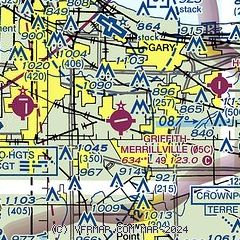
| Sectional chart |
|---|
|
| Airport distance calculator |
|---|
|
|
| Sunrise and sunset |
|---|
|
Times for 09-Nov-2025
| | Local
(UTC-6) | | Zulu
(UTC) |
|---|
| Morning civil twilight | | 06:03 | | 12:03 |
| Sunrise | | 06:32 | | 12:32 |
| Sunset | | 16:35 | | 22:35 |
| Evening civil twilight | | 17:04 | | 23:04 |
|
| Current date and time |
|---|
| Zulu (UTC) | 09-Nov-2025 20:16:48 |
|---|
| Local (UTC-6) | 09-Nov-2025 14:16:48 |
|---|
|
| METAR |
|---|
KGYY
6nm N | 091950Z 31018G23KT 5SM -SN BR BKN023 BKN028 BKN033 01/M01 A3009
|
KIGQ
6nm W | 091955Z AUTO 31013G17KT 10SM BKN033 BKN039 OVC049 00/M07 A3010 RMK AO2 T00031066
|
KVPZ
18nm E | 092004Z AUTO 32015G27KT 2SM -SN BR FEW015 BKN022 OVC030 00/M01 A3005 RMK AO2 PK WND 33027/1959 P0000 T00001011
|
|
| TAF |
|---|
KGYY
6nm N | 091720Z 0918/1018 33015G25KT P6SM -SN SCT025 BKN035 FM100300 32015G25KT 3SM -SN SCT012 BKN025 FM100500 32015G25KT 3/4SM -SN BR BKN010 OVC020 TEMPO 1005/1009 1/4SM +TSSN FZFG VV006CB FM100900 01015G25KT 1SM -SN BR BKN012 OVC020 TEMPO 1011/1015 1/2SM SN FZFG VV008 FM101600 34015G23KT P6SM SCT025 BKN050
|
|
| NOTAMs |
|---|
NOTAMs are issued by the DoD/FAA and will open in a separate window not controlled by AirNav.
|
|

