FAA INFORMATION EFFECTIVE 22 JANUARY 2026
Location
| FAA Identifier: | IGQ |
| Lat/Long: | 41-32-05.7000N 087-31-46.3000W
41-32.095000N 087-31.771667W
41.5349167,-87.5295278
(estimated) |
| Elevation: | 619.7 ft. / 188.9 m (surveyed) |
| Variation: | 02W (1995) |
| From city: | 21 miles S of CHICAGO, IL |
| Time zone: | UTC -6 (UTC -5 during Daylight Saving Time) |
| Zip code: | 60411 |
Airport Operations
| Airport use: | Open to the public |
| Activation date: | 04/1940 |
| Control tower: | no |
| ARTCC: | CHICAGO CENTER |
| FSS: | KANKAKEE FLIGHT SERVICE STATION |
| NOTAMs facility: | IGQ (NOTAM-D service available) |
| Attendance: | 0700-1500 |
| Wind indicator: | lighted |
| Segmented circle: | no |
| Lights: | ACTVT REIL RWY 09, 18, 27 & 36; MIRL RWY 09/27 & 18/36; TWY LGTS - CTAF. MIRL RWY 18/36 PRESET TO LOW INTST; INCR INTST - CTAF. |
| Beacon: | white-green (lighted land airport)
Operates sunset to sunrise. |
Airport Communications
| CTAF/UNICOM: | 122.7 |
| WX AWOS-3PT: | 124.925 (708-889-6319) |
| CHICAGO APPROACH: | 128.2 |
| CHICAGO DEPARTURE: | 128.2 |
| LUCIT STAR: | 133.1 |
| WX AWOS-3PT at GYY (7 nm NE): | 134.575 (219-944-0010) |
| WX AWOS-AV at C56 (12 nm SW): | 119.125 (708-534-5256) |
| WX ASOS at MDW (18 nm NW): | PHONE 773-884-4424 |
Nearby radio navigation aids
| VOR radial/distance | | VOR name | | Freq | | Var |
|---|
| CGTr050/2.4 | | CHICAGO HEIGHTS VORTAC | | 114.20 | | 02E |
| EONr034/19.8 | | PEOTONE VORTAC | | 113.20 | | 02E |
| JOTr089/35.4 | | JOLIET VOR/DME | | 112.30 | | 02E |
Airport Services
| Fuel available: | 100LL JET-A
100LL:SELF SERVE FUEL AVBL H24 WITH CREDIT CARD. |
| Parking: | hangars and tiedowns |
| Airframe service: | MAJOR |
| Powerplant service: | MAJOR |
| Bottled oxygen: | HIGH/LOW |
| Bulk oxygen: | HIGH/LOW |
Runway Information
Runway 18/36
| Dimensions: | 4002 x 75 ft. / 1220 x 23 m |
| Surface: | asphalt/treated/porous friction courses, in good condition |
| Weight bearing capacity: | |
| Runway edge lights: | medium intensity |
| RUNWAY 18 | | RUNWAY 36 |
| Latitude: | 41-32.170833N | | 41-31.511833N |
| Longitude: | 087-31.659833W | | 087-31.662000W |
| Elevation: | 616.6 ft. | | 618.5 ft. |
| Traffic pattern: | left | | left |
| Runway heading: | 182 magnetic, 180 true | | 002 magnetic, 000 true |
| Markings: | nonprecision, in fair condition | | nonprecision, in fair condition |
| Visual slope indicator: | 2-light PAPI on left (3.00 degrees glide path) | | 2-light PAPI on left (3.00 degrees glide path) |
| Runway end identifier lights: | yes | | yes |
| Touchdown point: | yes, no lights | | yes, no lights |
| Instrument approach: | | | LOC/DME |
Runway 9/27
| Dimensions: | 3395 x 75 ft. / 1035 x 23 m |
| Surface: | asphalt/treated/porous friction courses, in good condition |
| Weight bearing capacity: | |
| Runway edge lights: | medium intensity |
| RUNWAY 9 | | RUNWAY 27 |
| Latitude: | 41-32.393833N | | 41-32.392167N |
| Longitude: | 087-32.274000W | | 087-31.529833W |
| Elevation: | 614.5 ft. | | 616.6 ft. |
| Traffic pattern: | left | | left |
| Runway heading: | 092 magnetic, 090 true | | 272 magnetic, 270 true |
| Markings: | nonprecision, in fair condition | | nonprecision, in fair condition |
| Visual slope indicator: | 2-light PAPI on left (3.00 degrees glide path) | | 2-light PAPI on left (3.00 degrees glide path) |
| Runway end identifier lights: | yes | | yes |
| Touchdown point: | yes, no lights | | yes, no lights |
| Obstructions: | 26 ft. bldg, 546 ft. from runway, 95 ft. left of centerline, 13:1 slope to clear | | none |
Airport Ownership and Management from official FAA records
| Ownership: | Publicly-owned |
| Owner: | VILLAGE OF LANSING
3141 RIDGE RD
LANSING, IL 60438-3021
Phone (708) 895-7200 |
| Manager: | BRIAN HANIGAN
3250 BOB MALKAS DR
LANSING, IL 60438
Phone (708) 418-5888
(708) 895-7200 |
Additional Remarks
| - | ALL PATTERN FLYING IN NOISE SENSITIVE AREA. |
| - | BIRDS & WILDLIFE ON & INVOF ARPT. |
| - | 146 FT TOWER 4325 FT FROM RY 27 665 FT RIGHT OF EXTENDED CNTRLN. |
| - | FOR CD CTC CHICAGO APCH AT 847-289-0926. |
Instrument Procedures
NOTE: All procedures below are presented as PDF files. If you need a reader for these files, you should download the free Adobe Reader.NOT FOR NAVIGATION. Please procure official charts for flight.
FAA instrument procedures published for use from 22 January 2026 at 0901Z to 19 February 2026 at 0900z.
STARs - Standard Terminal Arrivals |
|---|
| LUCIT THREE (RNAV) **CHANGED** | |
2 pages:
[1] [2] (343KB) |
| PANGG SEVEN (RNAV) **CHANGED** | |
2 pages:
[1] [2] (444KB) |
IAPs - Instrument Approach Procedures |
|---|
| RNAV (GPS) RWY 09 | |
download (195KB) |
| RNAV (GPS) RWY 27 | |
download (247KB) |
| RNAV (GPS) RWY 36 | |
download (202KB) |
| LOC RWY 36 | |
download (232KB) |
| VOR-A | |
download (182KB) |
| NOTE: Special Alternate Minimums apply | |
download (161KB) |
| NOTE: Special Take-Off Minimums/Departure Procedures apply | |
download (201KB) |
Other nearby airports with instrument procedures:
05C - Griffith-Merrillville Airport (6 nm E)
KGYY - Gary/Chicago International Airport (7 nm NE)
C56 - Bult Field Airport (12 nm SW)
3HO - Hobart Sky Ranch Airport (12 nm E)
KMDW - Chicago Midway International Airport (18 nm NW)
|
|

Road maps at:
MapQuest
Bing
Google
| Aerial photo |
|---|
WARNING: Photo may not be current or correct
 Photo taken 21-Jul-2017
looking south.
Photo taken 21-Jul-2017
looking south.
Do you have a better or more recent aerial photo of Lansing Municipal Airport that you would like to share? If so, please send us your photo.
|
| Sectional chart |
|---|
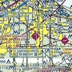
|
CAUTION: Diagram may not be current

| Airport distance calculator |
|---|
|
|
| Sunrise and sunset |
|---|
|
Times for 25-Jan-2026
| | Local
(UTC-6) | | Zulu
(UTC) |
|---|
| Morning civil twilight | | 06:39 | | 12:39 |
| Sunrise | | 07:09 | | 13:09 |
| Sunset | | 16:56 | | 22:56 |
| Evening civil twilight | | 17:26 | | 23:26 |
|
| Current date and time |
|---|
| Zulu (UTC) | 25-Jan-2026 13:41:22 |
|---|
| Local (UTC-6) | 25-Jan-2026 07:41:22 |
|---|
|
| METAR |
|---|
| KIGQ | 251315Z AUTO 08003KT 1 1/4SM -SN M13/M15 A3019 RMK AO2 T11271150
|
KGYY
7nm NE | 251050Z 08010KT 1SM -SN BR OVC005 M12/M12 A3020
|
KMDW
18nm NW | 251253Z 36006KT 1SM R04R/5000FT -SN BR VV010 M13/M15 A3017 RMK AO2 SLP240 P0000 T11281150
|
|
| TAF |
|---|
KGYY
7nm NE | 251125Z 2512/2612 06011KT 1 1/2SM -SN BR BKN006 OVC010 FM251900 36013G22KT 1 1/2SM -SN BR SCT006 OVC010 TEMPO 2519/2523 01012G20KT 1/2SM SN FZFG VV004 FM260000 34014G23KT P6SM SCT025 BKN050
|
KMDW
18nm NW | 251137Z 2512/2618 36011KT 1 1/2SM -SN BR OVC015 TEMPO 2515/2519 02012G20KT 1SM -SN BR VV010 FM252100 34014G23KT P6SM SCT025 BKN050
|
|
| NOTAMs |
|---|
NOTAMs are issued by the DoD/FAA and will open in a separate window not controlled by AirNav.
|
|


