FAA INFORMATION EFFECTIVE 14 MAY 2026
Location
| FAA Identifier: | 06D |
| Lat/Long: | 48-53-03.9020N 099-37-15.3360W
48-53.065033N 099-37.255600W
48.8844172,-99.6209267
(estimated) |
| Elevation: | 1822.6 ft. / 555.5 m (surveyed) |
| Variation: | 05E (2015) |
| From city: | 2 miles N of ROLLA, ND |
| Time zone: | UTC -5 (UTC -6 during Standard Time) |
| Zip code: | 58367 |
Airport Operations
| Airport use: | Open to the public |
| Activation date: | 01/1947 |
| Control tower: | no |
| ARTCC: | MINNEAPOLIS CENTER |
| FSS: | GRAND FORKS FLIGHT SERVICE STATION |
| NOTAMs facility: | GFK (NOTAM-D service available) |
| Attendance: | ON CALL
FOR ATTENDANT CALL 701-550-9884 OR 701-550-0134. |
| Wind indicator: | lighted |
| Segmented circle: | no |
| Lights: | ACTVT MIRL RY 14/32 & PAPI RYS 14 & 32 - CTAF. |
| Beacon: | white-green (lighted land airport)
Operates sunset to sunrise. |
Airport Communications
| CTAF/UNICOM: | 122.8 |
| WX AWOS-3: | 118.125 (701-477-0055) |
- APCH/DEP SVC PRVDD BY MINNEAPOLIS ARTCC ON FREQS 127.6/279.6 (MINOT RCAG).
- COMMUNICATIONS PRVDD BY GRAND FORKS RADIO ON FREQ 122.4 (ROLLA RCO).
Airport Services
| Fuel available: | 100LL JET-A
100LL:24 HOUR SELF SERVICE CREDIT CARD FUEL AVBL. |
| Parking: | hangars and tiedowns |
| Airframe service: | NONE |
| Powerplant service: | NONE |
| Bottled oxygen: | NONE |
| Bulk oxygen: | NONE |
Runway Information
Runway 14/32
| Dimensions: | 4300 x 75 ft. / 1311 x 23 m |
| Surface: | asphalt, in fair condition |
| Weight bearing capacity: | |
| Runway edge lights: | medium intensity |
| RUNWAY 14 | | RUNWAY 32 |
| Latitude: | 48-53.391412N | | 48-52.779162N |
| Longitude: | 099-37.551615W | | 099-37.015395W |
| Elevation: | 1822.6 ft. | | 1816.5 ft. |
| Traffic pattern: | left | | left |
| Runway heading: | 145 magnetic, 150 true | | 325 magnetic, 330 true |
| Markings: | nonprecision, in fair condition | | nonprecision, in fair condition |
| Visual slope indicator: | 2-light PAPI on left (3.00 degrees glide path) | | 2-light PAPI on left (3.00 degrees glide path) |
| Touchdown point: | yes, no lights | | yes, no lights |
Runway 7/25
| Dimensions: | 2200 x 75 ft. / 671 x 23 m |
| Surface: | turf, in good condition |
| RUNWAY 7 | | RUNWAY 25 |
| Latitude: | 48-52.999750N | | 48-53.051133N |
| Longitude: | 099-37.472590W | | 099-36.929650W |
| Elevation: | 1820.8 ft. | | 1811.9 ft. |
| Traffic pattern: | left | | left |
| Runway heading: | 077 magnetic, 082 true | | 257 magnetic, 262 true |
| Touchdown point: | yes, no lights | | yes, no lights |
Airport Ownership and Management from official FAA records
| Ownership: | Publicly-owned |
| Owner: | ROLLA AIRPORT AUTHORITY
10125 COUNTY RD 23
ROLLA, ND 58367
Phone 701-550-9884 |
| Manager: | GORDON KRECH
1104 6TH ST NE
ROLLA, ND 58367
Phone 701-550-9884
ADDNL PHONE CELL PHONE 701-550-0134 OR AL KRECH 701-550-9885. |
Additional Remarks
| - | FOR SNOW REMOVAL & ARPT CONDS CALL AMGR 701-550-9884, 701-550-0134 OR 701-550-9885. |
| - | RY 07/25 CLSD WINTER MONTHS (OCT-APR) DUE TO LACK OF SNOW REMOVAL. |
| - | WATERFOWL & BIRDS ON & INVOF AIRPORT. |
| - | FOR AWOS CALL 701-477-0055. |
| - | FOR CD IF UNA TO CTC ON FSS FREQ, CTC MINNEAPOLIS ARTCC AT 651-463-5588. |
Instrument Procedures
NOTE: All procedures below are presented as PDF files. If you need a reader for these files, you should download the free Adobe Reader.NOT FOR NAVIGATION. Please procure official charts for flight.
FAA instrument procedures published for use from 14 May 2026 at 0901Z to 11 June 2026 at 0900Z.
IAPs - Instrument Approach Procedures |
|---|
| RNAV (GPS) RWY 32 | |
download (255KB) |
| NOTE: Special Alternate Minimums apply | |
download (154KB) |
| NOTE: Special Take-Off Minimums/Departure Procedures apply | |
download (406KB) |
Other nearby airports with instrument procedures:
9D7 - Cando Municipal Airport (29 nm SE)
D09 - Bottineau Municipal Airport (32 nm W)
KRUG - Rugby Municipal Airport (34 nm SW)
D55 - Robertson Field Airport (49 nm E)
KDVL - Devils Lake Regional Airport (54 nm SE)
|
|

Road maps at:
MapQuest
Bing
Google
| Aerial photo |
|---|
WARNING: Photo may not be current or correct

Do you have a better or more recent aerial photo of Rolla Municipal Airport/Leonard Krech Field that you would like to share? If so, please send us your photo.
|
| Sectional chart |
|---|
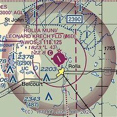
|
| Airport distance calculator |
|---|
|
|
| Sunrise and sunset |
|---|
|
Times for 10-Jun-2026
| | Local
(UTC-5) | | Zulu
(UTC) |
|---|
| Morning civil twilight | | 04:54 | | 09:54 |
| Sunrise | | 05:36 | | 10:36 |
| Sunset | | 21:40 | | 02:40 |
| Evening civil twilight | | 22:22 | | 03:22 |
|
| Current date and time |
|---|
| Zulu (UTC) | 10-Jun-2026 10:55:15 |
|---|
| Local (UTC-5) | 10-Jun-2026 05:55:15 |
|---|
|
| METAR |
|---|
| K06D | 101035Z AUTO 23009KT 10SM CLR 14/15 A2939 RMK AO2
|
|
| NOTAMs |
|---|
NOTAMs are issued by the DoD/FAA and will open in a separate window not controlled by AirNav.
|
|

