FAA INFORMATION EFFECTIVE 14 MAY 2026
Location
| FAA Identifier: | 06N |
| Lat/Long: | 41-25-54.8830N 074-23-29.6190W
41-25.914717N 074-23.493650W
41.4319119,-74.3915608
(estimated) |
| Elevation: | 522.7 ft. / 159.3 m (surveyed) |
| Variation: | 13W (2000) |
| From city: | 2 miles SE of MIDDLETOWN, NY |
| Time zone: | UTC -4 (UTC -5 during Standard Time) |
| Zip code: | 10940 |
Airport Operations
| Airport use: | Open to the public |
| Activation date: | 05/1946 |
| Control tower: | no |
| ARTCC: | NEW YORK CENTER |
| FSS: | NEW YORK FLIGHT SERVICE STATION |
| NOTAMs facility: | ISP (NOTAM-D service available) |
| Attendance: | UNATNDD |
| Wind indicator: | yes |
| Segmented circle: | no |
| Lights: | ACTVT PAPI RWY 08; MIRL RWY 08/26 - CTAF. |
Airport Communications
| CTAF/UNICOM: | 122.8 |
| NEW YORK APPROACH: | 132.75 |
| NEW YORK DEPARTURE: | 132.75 |
| WX ASOS at MGJ (7 nm NE): | 119.275 (845-457-1486) |
| WX ASOS at FWN (17 nm SW): | 118.525 (973-970-3780) |
Nearby radio navigation aids
| VOR radial/distance | | VOR name | | Freq | | Var |
|---|
| HUOr093/9.1 | | HUGUENOT VOR/DME | | 116.10 | | 11W |
| SAXr028/22.8 | | SPARTA VORTAC | | 115.70 | | 11W |
| IGNr253/29.2 | | KINGSTON VOR/DME | | 117.60 | | 12W |
| STWr050/33.9 | | STILLWATER VOR/DME | | 109.60 | | 11W |
| CMKr296/37.6 | | CARMEL VOR/DME | | 116.60 | | 12W |
| TEBr348/38.0 | | TETERBORO VOR/DME | | 108.40 | | 11W |
| NDB name | | Hdg/Dist | | Freq | | Var | | ID |
|---|
| NEELY | | 260/8.0 | | 335 | | 14W | | SW | ... .-- |
| STANWYCK | | 262/16.6 | | 261 | | 12W | | SKU | ... -.- ..- |
Airport Services
| Parking: | tiedowns |
| Airframe service: | NONE |
| Powerplant service: | NONE |
| Bottled oxygen: | NONE |
| Bulk oxygen: | NONE |
Runway Information
Runway 8/26
| Dimensions: | 2810 x 60 ft. / 856 x 18 m |
| Surface: | asphalt, in fair condition
SW STRENGTH IS 12.5. |
| Weight bearing capacity: | |
| Runway edge lights: | medium intensity
SEVERAL RWY AND TWY LGTS OTS INDEFLY. |
| Runway edge markings: | RUNWAY MARKINGS VERY BADLY FADED. |
| RUNWAY 8 | | RUNWAY 26 |
| Latitude: | 41-25.809045N | | 41-26.020390N |
| Longitude: | 074-23.767163W | | 074-23.220127W |
| Elevation: | 503.0 ft. | | 520.7 ft. |
| Traffic pattern: | left | | left |
| Runway heading: | 076 magnetic, 063 true | | 256 magnetic, 243 true |
| Displaced threshold: | 563 ft. | | no |
| Markings: | nonprecision, in poor condition | | nonprecision, in poor condition |
| Visual slope indicator: | 2-light PAPI on left (4.00 degrees glide path) | | 2-light PAPI on right (4.00 degrees glide path)
OTS INDEFLY. |
| Runway end identifier lights: | no | | no |
| Touchdown point: | yes, no lights | | yes, no lights |
| Obstructions: | 16 ft. road, 200 ft. from runway, 72 ft. right of centerline
+16FT ROAD, 0-200FT FRM RWY, 72FT RIGHT; +25FT TO +40FT TREES, 0-75FT FRM RWY, 120-140FT RT; +4FT FENCE, 0-200FT FRM RWY, 50 FT RT. | | 25 ft. trees, 295 ft. from runway, 110 ft. left of centerline, 3:1 slope to clear
RISING TERRAIN, +0FT TO +17FT HIGH, 0-200FT FRM RWY, 0-250FT RT; +25 FT TREES, 0-200FT FRM RWY, 175-200 FT LT. |
Airport Ownership and Management from official FAA records
| Ownership: | Privately-owned |
| Owner: | AERODROME DEV CORP
PO BOX 3062, 100 AIRPORT RD
MIDDLETOWN, NY 10940
Phone 845-343-5965 |
| Manager: | CHARLES BRODIE
P O BOX 3062, 100 AIRPORT RD
MIDDLETOWN, NY 10940
Phone 845-343-5965 |
Additional Remarks
| - | HVY GLIDER & HANG GLIDER ACT ON WKENDS & HOLS. |
| - | ULTRA-LIGHT ON AND INVOF ARPT. |
| - | FOR CD CTC NEW YORK APCH AT 516-683-2448. |
Instrument Procedures
NOTE: All procedures below are presented as PDF files. If you need a reader for these files, you should download the free Adobe Reader.NOT FOR NAVIGATION. Please procure official charts for flight.
FAA instrument procedures published for use from 14 May 2026 at 0901Z to 11 June 2026 at 0900Z.
IAPs - Instrument Approach Procedures |
|---|
| RNAV (GPS) RWY 08 | |
download (231KB) |
| RNAV (GPS) RWY 26 | |
download (228KB) |
| NOTE: Special Take-Off Minimums/Departure Procedures apply | |
download (150KB) |
Other nearby airports with instrument procedures:
KMGJ - Orange County Airport (7 nm NE)
N82 - Wurtsboro/Sullivan County Airport (10 nm N)
KSWF - New York Stewart International Airport (14 nm E)
KFWN - Sussex Airport (17 nm SW)
N89 - Joseph Y Resnick Airport (18 nm N)
4N1 - Greenwood Lake Airport (18 nm S)
|
|

Road maps at:
MapQuest
Bing
Google
| Aerial photo |
|---|
WARNING: Photo may not be current or correct
 Photo by Joshua Weinstein
Photo taken 03-Dec-2020
looking southwest.
Photo by Joshua Weinstein
Photo taken 03-Dec-2020
looking southwest.
Do you have a better or more recent aerial photo of Randall Airport that you would like to share? If so, please send us your photo.
|
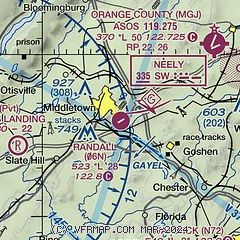
| Sectional chart |
|---|
|
| Airport distance calculator |
|---|
|
|
| Sunrise and sunset |
|---|
|
Times for 07-Jun-2026
| | Local
(UTC-4) | | Zulu
(UTC) |
|---|
| Morning civil twilight | | 04:52 | | 08:52 |
| Sunrise | | 05:25 | | 09:25 |
| Sunset | | 20:28 | | 00:28 |
| Evening civil twilight | | 21:01 | | 01:01 |
|
| Current date and time |
|---|
| Zulu (UTC) | 07-Jun-2026 21:16:10 |
|---|
| Local (UTC-4) | 07-Jun-2026 17:16:10 |
|---|
|
| METAR |
|---|
KMGJ
8nm NE | SuperAWOS
072054Z AUTO 36013G21KT 10SM FEW060 24/13 A2986 RMK AO2 PK WND 34026/2035 SLP109 T02440133 51018
|
KSWF
14nm E | 072045Z 33012G18KT 10SM SCT060 BKN080 24/14 A2986
|
KFWN
18nm SW | 072053Z AUTO 31009G18KT 270V350 10SM BKN055 26/12 A2989 RMK AO2 SLP117 T02610117 51016 $
|
|
| TAF |
|---|
KSWF
14nm E | 071955Z 0720/0824 30014G22KT P6SM BKN050 FM072200 33014G22KT P6SM BKN050 FM080100 35010G18KT P6SM BKN050 FM080400 04008KT P6SM SCT050 FM080900 08004KT P6SM FEW250 FM081900 15005KT P6SM FEW050 FM082100 20005KT P6SM FEW050 AMD NOT SKED
|
|
| NOTAMs |
|---|
NOTAMs are issued by the DoD/FAA and will open in a separate window not controlled by AirNav.
|
|

