FAA INFORMATION EFFECTIVE 11 JUNE 2026
Location
| FAA Identifier: | N82 |
| Lat/Long: | 41-35-52.4460N 074-27-32.9730W
41-35.874100N 074-27.549550W
41.5979017,-74.4591592
(estimated) |
| Elevation: | 548.4 ft. / 167.2 m (surveyed) |
| Variation: | 12W (1975) |
| From city: | 2 miles NE of WURTSBORO, NY |
| Time zone: | UTC -4 (UTC -5 during Standard Time) |
| Zip code: | 12790 |
Airport Operations
| Airport use: | Open to the public |
| Activation date: | 05/1947 |
| Control tower: | no |
| ARTCC: | NEW YORK CENTER |
| FSS: | NEW YORK FLIGHT SERVICE STATION |
| NOTAMs facility: | ISP (NOTAM-D service available) |
| Attendance: | 0900-1700
WINTER MONTHS ATTENDED TILL DUSK. |
| Wind indicator: | yes |
| Segmented circle: | no |
Airport Communications
| CTAF/UNICOM: | 122.8 |
| NEW YORK APPROACH: | 132.75 |
| NEW YORK DEPARTURE: | 132.75 |
| WX ASOS at MGJ (10 nm SE): | 119.275 (845-990-2308) |
| WX AWOS-3PT at MSV (16 nm W): | 124.725 (845-583-5056) |
Nearby radio navigation aids
| VOR radial/distance | | VOR name | | Freq | | Var |
|---|
| HUOr039/12.8 | | HUGUENOT VOR/DME | | 116.10 | | 11W |
| IGNr274/28.8 | | KINGSTON VOR/DME | | 117.60 | | 12W |
| SAXr017/32.0 | | SPARTA VORTAC | | 115.70 | | 11W |
| PWLr267/39.8 | | PAWLING VOR/DME | | 114.30 | | 12W |
| NDB name | | Hdg/Dist | | Freq | | Var | | ID |
|---|
| NEELY | | 317/12.4 | | 335 | | 14W | | SW | ... .-- |
| STANWYCK | | 295/19.1 | | 261 | | 12W | | SKU | ... -.- ..- |
Airport Services
| Fuel available: | 100LL |
| Parking: | hangars and tiedowns |
| Airframe service: | NONE |
| Powerplant service: | NONE |
| Bottled oxygen: | NONE |
| Bulk oxygen: | NONE |
Runway Information
Runway 5/23
| Dimensions: | 3591 x 60 ft. / 1095 x 18 m |
| Surface: | asphalt, in fair condition |
| Weight bearing capacity: | |
| Runway edge markings: | RY 05/23 MKGS FADED. |
| RUNWAY 5 | | RUNWAY 23 |
| Latitude: | 41-35.621702N | | 41-36.101557N |
| Longitude: | 074-27.820280W | | 074-27.359870W |
| Elevation: | 547.8 ft. | | 537.0 ft. |
| Traffic pattern: | left | | left |
| Runway heading: | 048 magnetic, 036 true | | 228 magnetic, 216 true |
| Displaced threshold: | 233 ft. | | no |
| Markings: | nonprecision, in poor condition | | nonprecision, in poor condition |
| Touchdown point: | yes, no lights | | yes, no lights |
| Obstructions: | 28 ft. trees, 372 ft. from runway, 66 ft. left of centerline, 6:1 slope to clear
RWY 05 HAS +8 FT BERM 50 FT FM THLD; +88 FT TREE, 139 FT FM THLD; 165 FT RIGHT. | | 17 ft. trees, 363 ft. from runway, 94 ft. left of centerline, 9:1 slope to clear
RWY 23: 40 FT TREES; 37 FT FM THLD, 161 FT RIGHT. 50FT TREES; 191 FT FM THLD,106 FT LEFT. |
Runway 9/27
| Dimensions: | 1101 x 110 ft. / 336 x 34 m |
| Surface: | turf, in fair condition |
| RUNWAY 9 | | RUNWAY 27 |
| Latitude: | 41-35.895483N | | 41-35.934005N |
| Longitude: | 074-27.535205W | | 074-27.299300W |
| Elevation: | 541.9 ft. | | 533.8 ft. |
| Traffic pattern: | left | | left |
| Runway heading: | 090 magnetic, 078 true | | 270 magnetic, 258 true |
| Touchdown point: | yes, no lights | | yes, no lights |
| Obstructions: | 103 ft. trees, 977 ft. from runway, 68 ft. left of centerline, 9:1 slope to clear | | 79 ft. trees, 95 ft. from runway, 113 ft. left of centerline, 1:1 slope to clear |
Airport Ownership and Management from official FAA records
| Ownership: | Privately-owned |
| Owner: | WURTSBORO AIRPORT FOUNDATION
WURTSBORO AIRPORT, ROUTE 209, P.O. BOX 129
WURTSBORO, NY 12790
Phone 845-888-2791 |
| Manager: | DANIEL YATES
WURTSBORO AIRPARK, LLC, 50 BARONE RD
WURTSBORO, NY 12790
Phone (845) 888-2791 |
Additional Remarks
| - | DEER ON & INVOF ARPT. |
| - | EXTSV GLIDER ACTIVITY. |
| - | FOR CD CTC NEW YORK APCH AT 516-683-2448 |
Instrument Procedures
NOTE: All procedures below are presented as PDF files. If you need a reader for these files, you should download the free Adobe Reader.NOT FOR NAVIGATION. Please procure official charts for flight.
FAA instrument procedures published for use from 11 June 2026 at 0901Z to 09 July 2026 at 0900z.
IAPs - Instrument Approach Procedures |
|---|
| VOR/DME OR GPS RWY 05 | |
download (209KB) |
| NOTE: Special Take-Off Minimums/Departure Procedures apply | |
download (442KB) |
Other nearby airports with instrument procedures:
N89 - Joseph Y Resnick Airport (9 nm NE)
KMGJ - Orange County Airport (10 nm SE)
06N - Randall Airport (10 nm S)
KMSV - Sullivan County International Airport (16 nm NW)
KSWF - New York Stewart International Airport (17 nm E)
|
|

Road maps at:
MapQuest
Bing
Google
| Aerial photo |
|---|
WARNING: Photo may not be current or correct
 Photo by Paul Norden
Taken in July 2016
Photo by Paul Norden
Taken in July 2016
Do you have a better or more recent aerial photo of Wurtsboro/Sullivan County Airport that you would like to share? If so, please send us your photo.
|
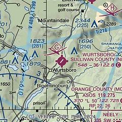
| Sectional chart |
|---|
|
| Airport distance calculator |
|---|
|
|
| Sunrise and sunset |
|---|
|
Times for 12-Jun-2026
| | Local
(UTC-4) | | Zulu
(UTC) |
|---|
| Morning civil twilight | | 04:50 | | 08:50 |
| Sunrise | | 05:24 | | 09:24 |
| Sunset | | 20:31 | | 00:31 |
| Evening civil twilight | | 21:05 | | 01:05 |
|
| Current date and time |
|---|
| Zulu (UTC) | 12-Jun-2026 12:33:11 |
|---|
| Local (UTC-4) | 12-Jun-2026 08:33:11 |
|---|
|
| METAR |
|---|
KMGJ
10nm SE | SuperAWOS
121154Z AUTO 25007KT 10SM BKN065 OVC080 22/21 A2974 RMK AO2 SLP068 70012 T02170211 10217 20200 50006
|
KMSV
16nm NW | 121156Z AUTO VRB03KT 8SM FEW004 OVC095 21/21 A2980 RMK AO2 RAE1057 SLP079 6//// 7//// T02060206 10206 20194 50003 PNO $
|
KSWF
18nm E | 121145Z 31004KT 10SM BKN 055 22/21 A2974
|
|
| TAF |
|---|
KSWF
18nm E | 121140Z 1212/1318 27007KT P6SM SCT050 SCT100 BKN250 FM121300 28007KT P6SM SCT100 FM121800 30011G19KT P6SM SCT040 BKN150 BKN250 TEMPO 1220/1224 2SM TSRA BKN030CB FM130200 32009KT P6SM SCT040 BKN100 BKN250 AMD NOT SKED
|
|
| NOTAMs |
|---|
NOTAMs are issued by the DoD/FAA and will open in a separate window not controlled by AirNav.
|
|

