FAA INFORMATION EFFECTIVE 09 JULY 2026
Location
| FAA Identifier: | MSV |
| Lat/Long: | 41-42-05.9000N 074-47-42.1000W
41-42.098333N 074-47.701667W
41.7016389,-74.7950278
(estimated) |
| Elevation: | 1403 ft. / 427.6 m (surveyed) |
| Variation: | 12W (1980) |
| From city: | 6 miles NW of MONTICELLO, NY |
| Time zone: | UTC -4 (UTC -5 during Standard Time) |
| Zip code: | 12783 |
Airport Operations
| Airport use: | Open to the public |
| Control tower: | no |
| ARTCC: | NEW YORK CENTER |
| FSS: | NEW YORK FLIGHT SERVICE STATION |
| NOTAMs facility: | MSV (NOTAM-D service available) |
| Attendance: | 0630-1700 |
| Wind indicator: | lighted |
| Segmented circle: | no |
| Lights: | ACTVT REIL RWY 15 & 33; HIRL RWY 15/33; TWY LGTS - CTAF. PAPI RWY 15 & 33 OPR CONSLY. |
| Beacon: | white-green (lighted land airport)
Operates sunset to sunrise. |
| Landing fee: | yes, LANDING FEE FOR ACFT OVER 8000 LBS & ALL COML ACFT REGARDLESS OF WEIGHT. |
| Fire and rescue: | ARFF index A |
| Airline operations: | PPR 24 HRS FOR ACR OPS WITH MORE THAN 30 PAX SEATS; CALL AMGR 845-807-0325 OR 845-665-1714. |
Airport Communications
| CTAF/UNICOM: | 122.8 |
| WX AWOS-3PT: | 124.725 (845-583-5056) |
| NEW YORK APPROACH: | 132.75 |
| NEW YORK DEPARTURE: | 132.75 |
| CLEARANCE DELIVERY: | 121.6 |
Nearby radio navigation aids
| VOR radial/distance | | VOR name | | Freq | | Var |
|---|
| HUOr343/19.8 | | HUGUENOT VOR/DME | | 116.10 | | 11W |
| DNYr177/29.5 | | DELANCEY VOR/DME | | 112.10 | | 11W |
| HNKr144/31.8 | | HANCOCK VOR/DME | | 116.80 | | 11W |
| SAXr354/39.8 | | SPARTA VORTAC | | 115.70 | | 11W |
| NDB name | | Hdg/Dist | | Freq | | Var | | ID |
|---|
| STANWYCK | | 299/35.2 | | 261 | | 12W | | SKU | ... -.- ..- |
Airport Services
| Fuel available: | 100LL JET-A
A:JET A FUEL AVBL; 0800-1700 CALL 845-807-0325. AFTR HRS ADVN NOTICE REQ.
100LL:SELF SVC 100LL FUEL AVBL 24 HRS DLY. |
| Parking: | hangars and tiedowns |
| Airframe service: | MAJOR |
| Powerplant service: | MINOR |
| Bottled oxygen: | NONE |
| Bulk oxygen: | NONE |
Runway Information
Runway 15/33
| Dimensions: | 6298 x 150 ft. / 1920 x 46 m |
| Surface: | asphalt/grooved, in excellent condition |
| Weight bearing capacity: | | Single wheel: | 95.0 | | Double wheel: | 131.0 | | Double tandem: | 223.0 |
|
| Runway edge lights: | high intensity |
| RUNWAY 15 | | RUNWAY 33 |
| Latitude: | 41-42.512522N | | 41-41.685092N |
| Longitude: | 074-48.117967W | | 074-47.284115W |
| Elevation: | 1402.8 ft. | | 1380.1 ft. |
| Traffic pattern: | left | | left |
| Runway heading: | 155 magnetic, 143 true | | 335 magnetic, 323 true |
| Displaced threshold: | 298 ft. | | 300 ft. |
| Declared distances: | TORA:6298 TODA:6298 ASDA:6198 LDA:5900 | | TORA:6298 TODA:6298 ASDA:6098 LDA:5798 |
| Markings: | precision, in good condition | | nonprecision, in good condition |
| Visual slope indicator: | 4-light PAPI on left (3.00 degrees glide path) | | 4-light PAPI on left (3.00 degrees glide path) |
| Runway end identifier lights: | yes | | yes |
| Touchdown point: | yes, no lights | | yes, no lights |
| Instrument approach: | ILS/DME | | |
| Obstructions: | 62 ft. trees, 2050 ft. from runway, 750 ft. left of centerline, 29:1 slope to clear
8 FT GROUND AER 320 FT LEFT. | | 19 ft. trees, 520 ft. from runway, 500 ft. left of centerline, 16:1 slope to clear |
Airport Ownership and Management from official FAA records
| Ownership: | Publicly-owned |
| Owner: | SULLIVAN COUNTY DPW
100 NORTH ST
MONTICELLO, NY 12701
Phone 845-807-0261 |
| Manager: | RYAN BROWN
100 NORTH ST
MONTICELLO, NY 12701
Phone 845-807-0326 |
Additional Remarks
| A39-15/33 | PCR VALUE: 596/F/C/X/T |
| - | BIRDS/WATERFOWL, COYOTE & DEER ON & INVOF ARPT. |
| - | FOR CD CTC NEW YORK APCH AT 516-683-2448 OR 121.6 |
Instrument Procedures
NOTE: All procedures below are presented as PDF files. If you need a reader for these files, you should download the free Adobe Reader.NOT FOR NAVIGATION. Please procure official charts for flight.
FAA instrument procedures published for use from 09 July 2026 at 0901Z to 06 August 2026 at 0900Z.
IAPs - Instrument Approach Procedures |
|---|
| ILS OR LOC RWY 15 | |
download (257KB) |
| RNAV (GPS) RWY 15 | |
download (251KB) |
| RNAV (GPS) RWY 33 | |
download (276KB) |
| NOTE: Special Alternate Minimums apply | |
download (145KB) |
| NOTE: Special Take-Off Minimums/Departure Procedures apply | |
download (471KB) |
Other nearby airports with instrument procedures:
N82 - Wurtsboro/Sullivan County Airport (16 nm E)
N89 - Joseph Y Resnick Airport (19 nm E)
N30 - Cherry Ridge Airport (23 nm SW)
06N - Randall Airport (24 nm SE)
KMGJ - Orange County Airport (26 nm SE)
|
|

Road maps at:
MapQuest
Bing
Google
| Aerial photo |
|---|
WARNING: Photo may not be current or correct
 Photo by Andreas Lauschke
Taken in 2019
looking north.
Photo by Andreas Lauschke
Taken in 2019
looking north.
Do you have a better or more recent aerial photo of Sullivan County International Airport that you would like to share? If so, please send us your photo.
|
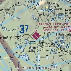
| Sectional chart |
|---|
|
CAUTION: Diagram may not be current

| Airport distance calculator |
|---|
|
|
| Sunrise and sunset |
|---|
|
Times for 24-Jul-2026
| | Local
(UTC-4) | | Zulu
(UTC) |
|---|
| Morning civil twilight | | 05:14 | | 09:14 |
| Sunrise | | 05:47 | | 09:47 |
| Sunset | | 20:25 | | 00:25 |
| Evening civil twilight | | 20:57 | | 00:57 |
|
| Current date and time |
|---|
| Zulu (UTC) | 24-Jul-2026 08:24:36 |
|---|
| Local (UTC-4) | 24-Jul-2026 04:24:36 |
|---|
|
| METAR |
|---|
| KMSV | 240756Z AUTO 02003KT 10SM CLR 11/10 A3025 RMK AO2 SLP242 T01060100 PNO $
|
|
| TAF |
|---|
KSWF
34nm E | 240520Z 2406/2512 00000KT P6SM SKC FM241600 14003KT P6SM SKC FM241800 19005KT P6SM FEW050 FM250200 16003KT P6SM SKC AMD NOT SKED
|
KPOU
41nm E | 240525Z 2406/2506 00000KT P6SM SKC TEMPO 2408/2411 4SM BR FM241600 19004KT P6SM FEW060 FEW250 FM242300 VRB03KT P6SM FEW250
|
|
| NOTAMs |
|---|
NOTAMs are issued by the DoD/FAA and will open in a separate window not controlled by AirNav.
|
|


