FAA INFORMATION EFFECTIVE 11 JUNE 2026
Location
| FAA Identifier: | MGJ |
| Lat/Long: | 41-30-42.5220N 074-15-48.7410W
41-30.708700N 074-15.812350W
41.5118117,-74.2635392
(estimated) |
| Elevation: | 369.9 ft. / 112.7 m (surveyed) |
| Variation: | 14W (2000) |
| From city: | 1 mile SW of MONTGOMERY, NY |
| Time zone: | UTC -4 (UTC -5 during Standard Time) |
| Zip code: | 12549 |
Airport Operations
| Airport use: | Open to the public |
| Activation date: | 07/1943 |
| Control tower: | no |
| ARTCC: | NEW YORK CENTER |
| FSS: | NEW YORK FLIGHT SERVICE STATION |
| NOTAMs facility: | MGJ (NOTAM-D service available) |
| Attendance: | SUN 0830-1630, NOV--APR MON-SAT 0700-1700, MAY-OCT MON-SAT 0700-1900 |
| Pattern altitude: | TPA: 1030 FT AGL SINGL ENG, 1330 FT AGL MULT ENG/TURBOPROP/JET. |
| Wind indicator: | lighted, WIND IND ON RWYS 04, 22, 26. |
| Segmented circle: | yes
SEGMENTED CRC WITH WIND CONE LCTD MID FLD IN AREA BTN RWYS. |
| Lights: | ACTVT HIRL RWY 04/22; MIRL RWY 08/26; TWY LGTS - CTAF. REIL RWY 04 & 22; PAPI RWYS 04 & 22; 08 & 26 OPR CONSLY. PCL ONLY AVBL SS-SR. |
| Beacon: | white-green (lighted land airport)
Operates sunset to sunrise. |
Airport Communications
| CTAF/UNICOM: | 122.725 |
| WX ASOS: | 119.275 (845-990-2308) |
| NEW YORK APPROACH: | 132.75 |
| NEW YORK DEPARTURE: | 132.75 |
| CLEARANCE DELIVERY: | 123.85 |
| WX ASOS at POU (18 nm E): | 126.75 (845-836-6748) |
Nearby radio navigation aids
| VOR radial/distance | | VOR name | | Freq | | Var |
|---|
| HUOr078/16.0 | | HUGUENOT VOR/DME | | 116.10 | | 11W |
| IGNr257/21.8 | | KINGSTON VOR/DME | | 117.60 | | 12W |
| SAXr036/29.4 | | SPARTA VORTAC | | 115.70 | | 11W |
| PWLr254/33.5 | | PAWLING VOR/DME | | 114.30 | | 12W |
| CMKr306/33.7 | | CARMEL VOR/DME | | 116.60 | | 12W |
| NDB name | | Hdg/Dist | | Freq | | Var | | ID |
|---|
| NEELY | | 328/2.2 | | 335 | | 14W | | SW | ... .-- |
| STANWYCK | | 276/9.9 | | 261 | | 12W | | SKU | ... -.- ..- |
Airport Services
| Fuel available: | 100LL JET-A |
| Parking: | hangars |
| Airframe service: | MAJOR |
| Powerplant service: | MAJOR |
| Bottled oxygen: | HIGH/LOW |
| Bulk oxygen: | HIGH/LOW |
Runway Information
Runway 4/22
| Dimensions: | 5006 x 100 ft. / 1526 x 30 m |
| Surface: | asphalt/grooved, in excellent condition |
| Weight bearing capacity: | | Single wheel: | 30.0 | | Double wheel: | 57.0 | | Double tandem: | 85.0 |
|
| Runway edge lights: | high intensity |
| RUNWAY 4 | | RUNWAY 22 |
| Latitude: | 41-30.482308N | | 41-31.245373N |
| Longitude: | 074-16.090080W | | 074-15.675243W |
| Elevation: | 355.0 ft. | | 369.9 ft. |
| Traffic pattern: | left | | right |
| Runway heading: | 036 magnetic, 022 true | | 216 magnetic, 202 true |
| Markings: | precision, in good condition | | precision, in good condition |
| Visual slope indicator: | 4-light PAPI on left (3.00 degrees glide path) | | 2-light PAPI on left (3.00 degrees glide path) |
| Runway end identifier lights: | yes | | yes |
| Touchdown point: | yes, no lights | | yes, no lights |
| Instrument approach: | ILS | | |
| Obstructions: | 54 ft. trees, 555 ft. from runway, 489 ft. left of centerline, 6:1 slope to clear | | 65 ft. trees, 1272 ft. from runway, 523 ft. right of centerline, 16:1 slope to clear |
Runway 8/26
| Dimensions: | 3664 x 100 ft. / 1117 x 30 m |
| Surface: | asphalt, in good condition |
| Weight bearing capacity: | | Single wheel: | 30.0 | | Double wheel: | 57.0 | | Double tandem: | 85.0 |
|
| Runway edge lights: | medium intensity |
| RUNWAY 8 | | RUNWAY 26 |
| Latitude: | 41-30.375143N | | 41-30.618322N |
| Longitude: | 074-16.083545W | | 074-15.349000W |
| Elevation: | 352.0 ft. | | 364.1 ft. |
| Traffic pattern: | left | | right |
| Runway heading: | 080 magnetic, 066 true | | 260 magnetic, 246 true |
| Displaced threshold: | no | | 315 ft. |
| Markings: | nonprecision, in good condition | | precision, in good condition |
| Visual slope indicator: | 2-light PAPI on left (3.50 degrees glide path) | | 2-light PAPI on left (3.50 degrees glide path) |
| Touchdown point: | yes, no lights | | yes, no lights |
| Obstructions: | 49 ft. trees, 790 ft. from runway, 180 ft. left of centerline, 12:1 slope to clear | | 87 ft. fence, 526 ft. from runway, 138 ft. left of centerline, 3:1 slope to clear
RWY 26 APCH SLOPE 11:1 DUE TO 56 FT TREE 644 FT FM DTHR. |
Airport Ownership and Management from official FAA records
| Ownership: | Publicly-owned |
| Owner: | ORANGE COUNTY
255 MAIN STREET
GOSHEN, NY 10924
Phone 845-291-4000 |
| Manager: | EDWARD MAGRYTA
500 DUNN RD.
MONTGOMERY, NY 12549-2402
Phone 845-457-4925 |
Additional Remarks
| - | 9 FT STABILIZED SHOULDER EACH SIDE OF RWY 8/26. |
| - | FUEL AVAIL. AFT HRS BY CREDIT CARD SELF-SVC RAMP. |
| - | DEER AND BIRDS ON AND INVOF ARPT. |
| - | RWY 04 DESGND CALM WIND RWY. |
| - | FOR CD CTC NEW YORK APCH AT 516-683-2448 OR 123.85 |
| - | RWY 04-22 HIRLS ON PHOTOCELL DRG DAY, ON REMOTE AT NGT. |
| - | NOISE ABATEMENT PROCEDURES IN EFCT; CTC AMGR 845-457-4925. |
| - | BE AWARE OF LRG TBJT ACFT INVOF STEWART ARPT LCTD 7 NM ESE. 800 FT HILL 1/2 MILE NW OF ARPT ON DOWNWIND/BASE LEG FOR RWY 22. |
| - | SAWRS |
Instrument Procedures
NOTE: All procedures below are presented as PDF files. If you need a reader for these files, you should download the free Adobe Reader.NOT FOR NAVIGATION. Please procure official charts for flight.
FAA instrument procedures published for use from 11 June 2026 at 0901Z to 09 July 2026 at 0900z.
IAPs - Instrument Approach Procedures |
|---|
| ILS OR LOC RWY 04 | |
download (263KB) |
| RNAV (GPS) RWY 04 | |
download (215KB) |
| RNAV (GPS) RWY 08 | |
download (206KB) |
| RNAV (GPS) RWY 22 | |
download (228KB) |
| RNAV (GPS) RWY 26 | |
download (239KB) |
| NOTE: Special Alternate Minimums apply | |
download (165KB) |
| NOTE: Special Take-Off Minimums/Departure Procedures apply | |
download (463KB) |
Other nearby airports with instrument procedures:
KSWF - New York Stewart International Airport (7 nm E)
06N - Randall Airport (7 nm SW)
N82 - Wurtsboro/Sullivan County Airport (10 nm NW)
N89 - Joseph Y Resnick Airport (14 nm N)
KPOU - Hudson Valley Regional Airport (18 nm E)
|
|

Road maps at:
MapQuest
Bing
Google
| Aerial photo |
|---|
WARNING: Photo may not be current or correct
 Photo by Andreas Lauschke
Taken in 2016
looking west.
Photo by Andreas Lauschke
Taken in 2016
looking west.
Do you have a better or more recent aerial photo of Orange County Airport that you would like to share? If so, please send us your photo.
|
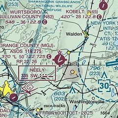
| Sectional chart |
|---|
|
| Airport distance calculator |
|---|
|
|
| Sunrise and sunset |
|---|
|
Times for 12-Jun-2026
| | Local
(UTC-4) | | Zulu
(UTC) |
|---|
| Morning civil twilight | | 04:50 | | 08:50 |
| Sunrise | | 05:24 | | 09:24 |
| Sunset | | 20:30 | | 00:30 |
| Evening civil twilight | | 21:04 | | 01:04 |
|
| Current date and time |
|---|
| Zulu (UTC) | 12-Jun-2026 04:21:58 |
|---|
| Local (UTC-4) | 12-Jun-2026 00:21:58 |
|---|
|
| METAR |
|---|
| KMGJ | SuperAWOS
120354Z AUTO 22005KT 10SM -RA CLR 22/21 A2974 RMK AO2 SLP068 P0004 T02170211
|
KSWF
8nm E | 120345Z 28006KT 10SM -DZ BKN060 22/22 A2975
|
KPOU
19nm NE | 120353Z 18003KT 10SM CLR 23/21 A2973 RMK AO2 SLP061 T02330206 $
|
|
| TAF |
|---|
KSWF
8nm E | 111945Z 1120/1224 25007KT P6SM SCT035 BKN060 PROB30 1120/1201 3SM TSRA BKN045CB BKN060 FM120100 27004KT P6SM BKN050 BKN150 BKN250 PROB30 1201/1203 5SM -SHRA BR BKN025 FM120300 VRB03KT P6SM BKN040 BKN150 BKN250 FM121600 29007KT P6SM SCT040 SCT150 SCT250 PROB30 1220/1224 3SM TSRA BKN040CB AMD NOT SKED
|
KPOU
19nm NE | 111737Z 1118/1218 27008KT P6SM FEW040 SCT060 FM120100 00000KT P6SM SCT050 BKN150 PROB30 1201/1204 VRB08G16KT 3SM TSRA BR SCT008 OVC025CB FM120400 00000KT P6SM FEW008 SCT050 OVC150 PROB30 1212/1215 6SM -SHRA BR SCT005 OVC020 FM121600 28005KT P6SM FEW020 SCT120
|
|
| NOTAMs |
|---|
NOTAMs are issued by the DoD/FAA and will open in a separate window not controlled by AirNav.
|
|


