FAA INFORMATION EFFECTIVE 19 MARCH 2026
Location
| FAA Identifier: | 0B8 |
| Lat/Long: | 41-15-07.7000N 072-01-53.9000W
41-15.128333N 072-01.898333W
41.2521389,-72.0316389
(estimated) |
| Elevation: | 7.2 ft. / 2.2 m (surveyed) |
| Variation: | 14W (1980) |
| From city: | 8 miles SE of FISHERS ISLAND, NY |
| Time zone: | UTC -4 (UTC -5 during Standard Time) |
| Zip code: | 06390 |
Airport Operations
| Airport use: | Open to the public |
| Control tower: | no |
| ARTCC: | BOSTON CENTER |
| FSS: | BRIDGEPORT FLIGHT SERVICE STATION |
| NOTAMs facility: | BDR (NOTAM-D service available) |
| Attendance: | MAY-OCT SUN 1000-1630, MAY-OCT MON-SAT 0800-1630, 1 NOV-30 APR/UNATNDD/
ARPT ATTENDED MAY-OCT MON THRU SAT 0800-1630; SUN 1000-1630; UNATNDD NOV-APR. |
| Wind indicator: | lighted |
| Segmented circle: | no |
| Lights: | ACTVT REIL RY 07/25 & RY 12/30; PAPI RY 07/25 & RY 12/30; MIRL RY 07/25 & RY 12/30 - CTAF. |
| Landing fee: | yes |
Airport Communications
| CTAF/UNICOM: | 122.8 |
| PROVIDENCE APPROACH: | 125.75 |
| PROVIDENCE DEPARTURE: | 125.75 |
| WX ASOS at GON (5 nm N): | 127.0 (860-449-8921) |
| WX ASOS at WST (12 nm NE): | 132.375 (401-596-9543) |
- APCH/DEP SVC PRVDD BY BOSTON ARTCC ON FREQS 124.85/307.9 (WOODSTOCK RCAG) WHEN PROVIDENCE APCH CTL CLSD.
Nearby radio navigation aids
| VOR radial/distance | | VOR name | | Freq | | Var |
|---|
| GONr183/4.8 | | GROTON VOR/DME | | 110.85 | | 14W |
| ORWr199/18.3 | | NORWICH VOR/DME | | 110.00 | | 14W |
| SEYr299/21.2 | | SANDY POINT VOR/DME | | 117.80 | | 15W |
| HTOr046/23.8 | | HAMPTON VORTAC | | 113.60 | | 13W |
| MADr110/30.0 | | MADISON VOR/DME | | 110.40 | | 13W |
| HFDr148/32.9 | | HARTFORD VOR/DME | | 114.90 | | 13W |
| PVDr238/39.2 | | PROVIDENCE VOR/DME | | 115.60 | | 14W |
| CCCr074/39.7 | | CALVERTON VOR/DME | | 114.55 | | 13W |
Airport Services
| Parking: | tiedowns |
| Airframe service: | NONE |
| Powerplant service: | NONE |
| Bottled oxygen: | NONE |
| Bulk oxygen: | NONE |
Runway Information
Runway 12/30
| Dimensions: | 2345 x 100 ft. / 715 x 30 m |
| Surface: | asphalt, in excellent condition |
| Runway edge lights: | medium intensity |
| RUNWAY 12 | | RUNWAY 30 |
| Latitude: | 41-15.157220N | | 41-15.084350N |
| Longitude: | 072-02.145757W | | 072-01.643330W |
| Elevation: | 6.7 ft. | | 3.9 ft. |
| Traffic pattern: | left | | left |
| Runway heading: | 115 magnetic, 101 true | | 295 magnetic, 281 true |
| Markings: | basic, in good condition | | basic, in good condition |
| Visual slope indicator: | 2-light PAPI on left (3.00 degrees glide path) | | 2-light PAPI on right (3.00 degrees glide path) |
| Runway end identifier lights: | yes | | yes |
| Touchdown point: | yes, no lights | | yes, no lights |
| Obstructions: | 15 ft. road, 200 ft. from runway
RWY12; +15FT RD PARALLEL TO RWY 90 FT L. | | 5 ft. other, 200 ft. from runway, 78 ft. left of centerline
RY 30, 5 FT ROCK SEAWALL 70-85 FT L PARALLEL TO RY. |
Runway 7/25
| Dimensions: | 1806 x 75 ft. / 550 x 23 m |
| Surface: | asphalt, in good condition |
| Runway edge lights: | medium intensity |
| RUNWAY 7 | | RUNWAY 25 |
| Latitude: | 41-15.065995N | | 41-15.209058N |
| Longitude: | 072-02.075518W | | 072-01.730147W |
| Elevation: | 4.3 ft. | | 7.2 ft. |
| Traffic pattern: | left | | left |
| Runway heading: | 075 magnetic, 061 true | | 255 magnetic, 241 true |
| Markings: | basic, in good condition | | basic, in good condition |
| Visual slope indicator: | 2-light PAPI on left (3.75 degrees glide path) | | 2-light PAPI on left (3.00 degrees glide path) |
| Runway end identifier lights: | yes | | yes |
| Touchdown point: | yes, no lights | | yes, no lights |
| Obstructions: | 30 ft. gnd, lighted, 363 ft. from runway, 141 ft. left of centerline, 5:1 slope to clear
RWY 07; 6 FT ROCK/GRAVEL DUNE PARALLEL TO RWY 75 FT R. 6 FT ROCK/GRAVEL DUNE 165 FT FROM RWY PERPENDICULAR TO RWY. | | 10 ft. road, 246 ft. from runway, 22 ft. right of centerline, 4:1 slope to clear
RWY 25; +7 FT BRUSH 170-180 FT FROM THLD 42-61 FT L. |
Airport Ownership and Management from official FAA records
| Ownership: | Publicly-owned |
| Owner: | TOWN OF SOUTHOLD
PO BOX 607
FISHERS ISLAND, NY 06390
Phone 631-765-1800 |
| Manager: | DAVID MCCALL
PO BOX 607, 261 TRUMBULL DR
FISHERS ISLAND, NY 06390
Phone 917-675-0296
OR 860-460-7174 WHEN ATTENDED. |
Additional Remarks
| - | FOR CD CTC PROVIDENCE APCH AT 401-738-8945, WHEN APCH CLSD CTC BOSTON ARTCC AT 603-879-6859. |
Instrument Procedures
NOTE: All procedures below are presented as PDF files. If you need a reader for these files, you should download the free Adobe Reader.NOT FOR NAVIGATION. Please procure official charts for flight.
FAA instrument procedures published for use from 19 March 2026 at 0901Z to 16 April 2026 at 0900Z.
IAPs - Instrument Approach Procedures |
|---|
| VOR OR GPS-A | |
download (209KB) |
| NOTE: Special Take-Off Minimums/Departure Procedures apply | |
download (437KB) |
Other nearby airports with instrument procedures:
KGON - Groton-New London Airport (5 nm N)
KMTP - Montauk Airport (12 nm SE)
KWST - Westerly State Airport (12 nm NE)
KJPX - East Hampton Town Airport (20 nm SW)
KBID - Block Island State Airport (21 nm E)
|
|

Road maps at:
MapQuest
Bing
Google
| Aerial photo |
|---|
WARNING: Photo may not be current or correct
 Photo by Rob Donner
Taken in June 2020
from the east.
Photo by Rob Donner
Taken in June 2020
from the east.
Do you have a better or more recent aerial photo of Elizabeth Field Airport that you would like to share? If so, please send us your photo.
|
| Sectional chart |
|---|
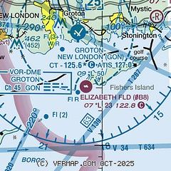
|
| Airport distance calculator |
|---|
|
|
| Sunrise and sunset |
|---|
|
Times for 10-Apr-2026
| | Local
(UTC-4) | | Zulu
(UTC) |
|---|
| Morning civil twilight | | 05:49 | | 09:49 |
| Sunrise | | 06:18 | | 10:18 |
| Sunset | | 19:21 | | 23:21 |
| Evening civil twilight | | 19:50 | | 23:50 |
|
| Current date and time |
|---|
| Zulu (UTC) | 10-Apr-2026 09:52:33 |
|---|
| Local (UTC-4) | 10-Apr-2026 05:52:33 |
|---|
|
| METAR |
|---|
KGON
5nm N | 100928Z AUTO 00000KT 3SM R05/2000VP6000FT BR SCT004 M01/M02 A3040 RMK AO2 T10111017
|
KWST
12nm NE | 100938Z AUTO 00000KT 2 1/2SM BR BKN004 M02/M02 A3040 RMK AO2 I1001 T10221022
|
KMTP
12nm SE | 100854Z AUTO 00000KT M01/M02 A3041 RMK AO1 SLP297 T10061017 56016
|
|
| TAF |
|---|
KGON
5nm N | 100734Z 1008/1106 VRB03KT 1/2SM FZFG OVC006 FM100830 VRB02KT 1SM BR BKN006 TEMPO 1011/1014 SCT006 FM101400 20006KT P6SM SCT015 SCT250 FM101600 19010G16KT P6SM SCT250 FM102000 18012KT P6SM SCT250 FM110200 20009KT P6SM SCT070 BKN120 FM110400 24006KT P6SM SCT030 BKN070
|
|
| NOTAMs |
|---|
NOTAMs are issued by the DoD/FAA and will open in a separate window not controlled by AirNav.
|
|

