FAA INFORMATION EFFECTIVE 09 JULY 2026
Location
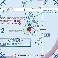
| FAA Identifier: | BID |
| Lat/Long: | 41-10-05.2000N 071-34-40.2000W
41-10.086667N 071-34.670000W
41.1681111,-71.5778333
(estimated) |
| Elevation: | 107.9 ft. / 32.9 m (surveyed) |
| Variation: | 15W (1985) |
| From city: | 1 mile W of BLOCK ISLAND, RI |
| Time zone: | UTC -4 (UTC -5 during Standard Time) |
| Zip code: | 02807 |
Airport Operations
| Airport use: | Open to the public |
| Activation date: | 06/1950 |
| Control tower: | no |
| ARTCC: | BOSTON CENTER |
| FSS: | BRIDGEPORT FLIGHT SERVICE STATION |
| NOTAMs facility: | BID (NOTAM-D service available) |
| Attendance: | JUN-SEP SUN-SAT 0800-1700, OCT-MAY SUN-SAT 0800-1600 |
| Wind indicator: | lighted |
| Segmented circle: | yes |
| Lights: | ACTVT REIL RWY 10 & 28; PAPI RWY 10 & 28; MIRL RWY 10/28 - CTAF. |
| Beacon: | white-green (lighted land airport)
Operates sunset to sunrise. |
| Landing fee: | yes, COML & NON RHODE ISLAND REGISTERED ACFT. |
Airport Communications
| CTAF/UNICOM: | 123.0 |
| WX AWOS-3PT: | 134.775 (401-466-5495) |
| PROVIDENCE APPROACH: | 125.75 |
| PROVIDENCE DEPARTURE: | 125.75 |
| CLEARANCE DELIVERY: | 120.1 |
| WX ASOS at WST (15 nm NW): | 132.375 (401-596-9543) |
- APCH/DEP SVC PRVDD BY BOSTON ARTCC ON FREQS 124.85/307.9 (WOODSTOCK RCAG) WHEN PROVIDENCE APCH CTL CLSD.
Nearby radio navigation aids
| VOR radial/distance | | VOR name | | Freq | | Var |
|---|
| SEY at field | | SANDY POINT VOR/DME | | 117.80 | | 15W |
| GONr128/23.5 | | GROTON VOR/DME | | 110.85 | | 14W |
| ORWr155/30.1 | | NORWICH VOR/DME | | 110.00 | | 14W |
| PVDr205/34.0 | | PROVIDENCE VOR/DME | | 115.60 | | 14W |
| HTOr079/36.6 | | HAMPTON VORTAC | | 113.60 | | 13W |
Airport Services
| Parking: | tiedowns |
| Airframe service: | NONE |
| Powerplant service: | NONE |
| Bottled oxygen: | NONE |
| Bulk oxygen: | NONE |
Runway Information
Runway 10/28
| Dimensions: | 2502 x 100 ft. / 763 x 30 m |
| Surface: | asphalt, in good condition |
| Weight bearing capacity: | |
| Runway edge lights: | medium intensity |
| RUNWAY 10 | | RUNWAY 28 |
| Latitude: | 41-10.064787N | | 41-10.109410N |
| Longitude: | 071-34.941505W | | 071-34.399467W |
| Elevation: | 107.7 ft. | | 101.4 ft. |
| Traffic pattern: | left | | left |
| Runway heading: | 099 magnetic, 084 true | | 279 magnetic, 264 true |
| Markings: | nonprecision, in good condition | | nonprecision, in good condition |
| Visual slope indicator: | 4-light PAPI on right (3.50 degrees glide path) | | 4-light PAPI on left (3.00 degrees glide path) |
| Runway end identifier lights: | yes | | yes |
| Touchdown point: | yes, no lights | | yes, no lights |
| Obstructions: | 88 ft. trees, 2000 ft. from runway, 40 ft. right of centerline, 20:1 slope to clear | | none
+9 FT FENCE, 0-200 FT FM RWY END, 150 FT L & 130 FT R. |
Airport Ownership and Management from official FAA records
| Ownership: | Publicly-owned |
| Owner: | STATE OF RHODE ISLAND
RI AIRPORT CORPORATION, 2000 POST RD
WARWICK, RI 02886
Phone 401-691-2227 |
| Manager: | IFTIKHAR AHMAD
RHODE ISLAND AIRPORT CORP, 2000 POST RD
WARWICK, RI 02886
Phone (401) 691-2265 |
Additional Remarks
| - | OBSTNS: LGTD TWRS 1 MI NE OF ARPT, 1/2 MI APART. |
| - | DEER & BIRDS ON & INVOF ARPT. |
| - | ARPT PRKG & SAFETY BRIEF AVBL ON LDG 122.85 MHZ OR CALL 401-466-5511. |
| - | RWY CONDS MAY NOT BE MNT OR RPRTD WHEN AP IS UNATNDD. CTC RI AP CORPORATION OPS AT 401-691-2265. |
| - | OVNGT PRKG FEE. |
| - | FOR CD WHEN APCH CLSD CTC BOSTON ARTCC AT 603-879-6859. |
| - | RWY 10/28 SAFETY AREA NOT STD SE |
| - | +15 FT DROPOFF 130 FT FM RWY END, 150 LEFT. |
Instrument Procedures
NOTE: All procedures below are presented as PDF files. If you need a reader for these files, you should download the free Adobe Reader.NOT FOR NAVIGATION. Please procure official charts for flight.
FAA instrument procedures published for use from 09 July 2026 at 0901Z to 06 August 2026 at 0900Z.
IAPs - Instrument Approach Procedures |
|---|
| RNAV (GPS) RWY 10 | |
download (209KB) |
| RNAV (GPS) RWY 28 | |
download (234KB) |
| VOR/DME RWY 10 | |
download (196KB) |
| NOTE: Special Alternate Minimums apply | |
download (153KB) |
| NOTE: Special Take-Off Minimums/Departure Procedures apply | |
download (178KB) |
Other nearby airports with instrument procedures:
KWST - Westerly State Airport (15 nm NW)
KMTP - Montauk Airport (16 nm W)
0B8 - Elizabeth Field Airport (21 nm W)
KGON - Groton-New London Airport (23 nm NW)
KUUU - Newport State Airport (26 nm NE)
|
|

Road maps at:
MapQuest
Bing
Google
| Aerial photo |
|---|
WARNING: Photo may not be current or correct
 Photo by Paulo Constantino
Photo taken 30-Aug-2012
looking northeast.
Photo by Paulo Constantino
Photo taken 30-Aug-2012
looking northeast.
Do you have a better or more recent aerial photo of Block Island State Airport that you would like to share? If so, please send us your photo.
|
| Sectional chart |
|---|
|
| Airport distance calculator |
|---|
|
|
| Sunrise and sunset |
|---|
|
Times for 10-Jul-2026
| | Local
(UTC-4) | | Zulu
(UTC) |
|---|
| Morning civil twilight | | 04:51 | | 08:51 |
| Sunrise | | 05:24 | | 09:24 |
| Sunset | | 20:19 | | 00:19 |
| Evening civil twilight | | 20:53 | | 00:53 |
|
| Current date and time |
|---|
| Zulu (UTC) | 10-Jul-2026 12:50:47 |
|---|
| Local (UTC-4) | 10-Jul-2026 08:50:47 |
|---|
|
| METAR |
|---|
| KBID | 101156Z AUTO 27005KT 4SM BR OVC001 22/21 A2977 RMK AO2 SLP081 6//// 7//// T02170211 10217 20200 53005 PNO $
|
KWST
15nm NW | 101153Z AUTO VRB05KT 10SM CLR 25/22 A2976 RMK AO2 SLP077 T02500222 10250 20217 53006
|
KMTP
16nm W | 101154Z AUTO VRB04KT 23/22 A2977 RMK AO1 SLP081 T02330222 10233 20200 51006 $
|
|
| TAF |
|---|
KGON
23nm NW | 101128Z 1012/1112 28005KT P6SM SCT007 BKN250 TEMPO 1012/1013 3SM BR BKN007 FM101300 29008KT P6SM SCT015 BKN250 FM101800 26009KT P6SM SCT045 BKN200 FM110000 VRB03KT P6SM BKN050 FM110500 03005KT P6SM BKN070
|
|
| NOTAMs |
|---|
NOTAMs are issued by the DoD/FAA and will open in a separate window not controlled by AirNav.
|
|


