FAA INFORMATION EFFECTIVE 14 MAY 2026
Location
| FAA Identifier: | MTP |
| Lat/Long: | 41-04-36.0000N 071-55-13.7000W
41-04.600000N 071-55.228333W
41.0766667,-71.9204722
(estimated) |
| Elevation: | 6.8 ft. / 2.1 m (surveyed) |
| Variation: | 15W (2000) |
| From city: | 3 miles NE of MONTAUK, NY |
| Time zone: | UTC -4 (UTC -5 during Standard Time) |
| Zip code: | 11954 |
Airport Operations
| Airport use: | Open to the public |
| Activation date: | 04/1958 |
| Control tower: | no |
| ARTCC: | BOSTON CENTER |
| FSS: | NEW YORK FLIGHT SERVICE STATION |
| NOTAMs facility: | MTP (NOTAM-D service available) |
| Attendance: | APR-OCT DAYLIGHT HOURS
ATNDD APR 15 - OCT. |
| Wind indicator: | lighted |
| Segmented circle: | no |
| Lights: | ACTVT MIRL & PAPI RWY 06/24 - 121.7. |
| Landing fee: | yes |
Airport Communications
| CTAF/UNICOM: | 122.7 |
| NEW YORK APPROACH: | 125.975 |
| PROVIDENCE DEPARTURE: | 125.75 |
| WX ASOS at GON (16 nm N): | 127.0 (860-449-8921) |
| WX AWOS-3PT at BID (16 nm E): | 134.775 (401-466-5495) |
| WX AWOS-3PT at JPX (17 nm SW): | 118.075 (631-537-2527) |
| WX ASOS at WST (17 nm N): | 132.375 (401-596-9543) |
- DEP SVC PRVDD BY BOSTON ARTCC ON FREQS 124.85/269.2(WOODSTOCK RCAG) WHEN PROVIDENCE DEP CTL CLSD.
Nearby radio navigation aids
| VOR radial/distance | | VOR name | | Freq | | Var |
|---|
| GONr173/16.3 | | GROTON VOR/DME | | 110.85 | | 14W |
| SEYr266/16.5 | | SANDY POINT VOR/DME | | 117.80 | | 15W |
| HTOr075/20.3 | | HAMPTON VORTAC | | 113.60 | | 13W |
| ORWr187/29.0 | | NORWICH VOR/DME | | 110.00 | | 14W |
| MADr125/37.6 | | MADISON VOR/DME | | 110.40 | | 13W |
Airport Services
| Parking: | tiedowns |
| Airframe service: | NONE |
| Powerplant service: | NONE |
| Bottled oxygen: | NONE |
| Bulk oxygen: | NONE |
Runway Information
Runway 6/24
| Dimensions: | 3246 x 75 ft. / 989 x 23 m |
| Surface: | asphalt, in good condition |
| Runway edge lights: | medium intensity |
| RUNWAY 6 | | RUNWAY 24 |
| Latitude: | 41-04.418512N | | 41-04.782872N |
| Longitude: | 071-55.486010W | | 071-54.969098W |
| Elevation: | 6.8 ft. | | 4.3 ft. |
| Traffic pattern: | left | | right |
| Runway heading: | 062 magnetic, 047 true | | 242 magnetic, 227 true |
| Displaced threshold: | 302 ft. | | 668 ft. |
| Markings: | nonprecision, in good condition | | nonprecision, in good condition |
| Visual slope indicator: | 2-light PAPI on right (3.83 degrees glide path)
PAPI RWY 6 TEMP OTS. | | 2-light PAPI on left (4.00 degrees glide path) |
| Touchdown point: | yes, no lights | | yes, no lights |
| Obstructions: | 36 ft. trees, 200 ft. from runway, 238 ft. right of centerline
RWY 06, 5 FT FENCE, 200 FT FM THLD, 200 FT RT. 15 FT TREES, 117 FT FM THLD, 205 FT RT. 30 FT TREES, 0-200 FT FM THLD, 50 FT - 70 FT LT. | | 40 ft. hill, 208 ft. from runway, 48 ft. right of centerline
RWY 24, 25FT - 35FT TREES AND TERRAIN, 0-200 FT FM RWY, 200 FT RT TO 250 FT LT. |
Airport Ownership and Management from official FAA records
| Ownership: | Privately-owned |
| Owner: | MONTAUK AIRPORT INC
P.O. BOX 140
CENTERPORT, NY 11721
Phone 631-668-3738 |
| Manager: | NEIL BLANEY
BOX 140
CENTERPORT, NY 11721
Phone 631-609-0932 |
Additional Remarks
| A30A-24 | NO TOUCH AND GO. |
| - | PPR HEL OPNS SS-SR; CALL AMGR 631-668-3738. |
| - | FOR CD CTC PROVIDENCE APCH AT 401-738-8945, WHEN APCH CLSD CTC BOSTON ARTCC AT 603-879-6859. |
| - | NOISE ABATEMENT, RWY 24 DEP, RT ASAP. |
| - | DEER ON OR INVOF ARPT. |
| - | PPR JET ACFT; CALL AMGR 631-668-3738. |
| - | HELICOPTERS CALL FOR PRIOR PERMISSION TO LND ON RAMP AREA. |
| - | RWY 06; 18 FT BRUSH ALONG RWY EDGE 90 FT L; 30 FT POLE 400 FT FROM THLD 79 FT L; 31 FT POLE 216 FT FROM RWY THLD 233 FT R. |
| - | RWY 06; 26 FT TREE 382 FT FROM THLD 21 FT L; 25-32 FT TREES 180-255 FT FROM THLD 60-90 FT L; 11-17 FT TREES 225-270 FT FROM THLD 4-95 FT R. |
| - | RWY 24; 21 FT BRUSH ALONG RWY EDGE 87 FT R. |
| - | NO TOUCH AND GOES RWY 06/24. |
Instrument Procedures
NOTE: All procedures below are presented as PDF files. If you need a reader for these files, you should download the free Adobe Reader.NOT FOR NAVIGATION. Please procure official charts for flight.
FAA instrument procedures published for use from 14 May 2026 at 0901Z to 11 June 2026 at 0900Z.
STARs - Standard Terminal Arrivals |
|---|
| SARDI ONE (RNAV) | |
2 pages:
[1] [2] (476KB) |
IAPs - Instrument Approach Procedures |
|---|
| RNAV (GPS) RWY 06 | |
download (242KB) |
| RNAV (GPS) RWY 24 | |
download (240KB) |
| NOTE: Special Take-Off Minimums/Departure Procedures apply | |
download (150KB) |
Other nearby airports with instrument procedures:
0B8 - Elizabeth Field Airport (12 nm NW)
KGON - Groton-New London Airport (16 nm N)
KBID - Block Island State Airport (16 nm E)
KJPX - East Hampton Town Airport (17 nm SW)
KWST - Westerly State Airport (17 nm N)
|
|

Road maps at:
MapQuest
Bing
Google
| Aerial photo |
|---|
WARNING: Photo may not be current or correct
 Photo by Timothy J. Quill
Photo taken 06-Jul-2019
looking northeast.
Photo by Timothy J. Quill
Photo taken 06-Jul-2019
looking northeast.
Do you have a better or more recent aerial photo of Montauk Airport that you would like to share? If so, please send us your photo.
|
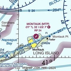
| Sectional chart |
|---|
|
| Airport distance calculator |
|---|
|
|
| Sunrise and sunset |
|---|
|
Times for 09-Jun-2026
| | Local
(UTC-4) | | Zulu
(UTC) |
|---|
| Morning civil twilight | | 04:43 | | 08:43 |
| Sunrise | | 05:16 | | 09:16 |
| Sunset | | 20:18 | | 00:18 |
| Evening civil twilight | | 20:51 | | 00:51 |
|
| Current date and time |
|---|
| Zulu (UTC) | 09-Jun-2026 20:34:42 |
|---|
| Local (UTC-4) | 09-Jun-2026 16:34:42 |
|---|
|
| METAR |
|---|
| KMTP | 091954Z AUTO 23007G19KT 22/07 A3012 RMK AO1 SLP199 T02220067
|
KGON
16nm N | 091956Z AUTO 24009KT 10SM CLR 22/09 A3009 RMK AO2 SLP189 T02170094
|
KJPX
17nm SW | 092015Z AUTO 21009G14KT 10SM CLR 22/06 A3012 RMK AO2 T02150063
|
KBID
17nm E | 091956Z AUTO 23018G25KT 10SM CLR 19/10 A3011 RMK AO2 PK WND 23026/1912 SLP198 T01890100
|
KWST
17nm N | 091953Z AUTO 23011G19KT 10SM CLR 23/07 A3010 RMK AO2 SLP191 T02330072
|
|
| TAF |
|---|
KGON
16nm N | 091950Z 0920/1018 22012G20KT P6SM FEW250 FM100200 22006KT P6SM SCT250 FM101300 21008KT P6SM SCT050 BKN100
|
|
| NOTAMs |
|---|
NOTAMs are issued by the DoD/FAA and will open in a separate window not controlled by AirNav.
|
|

