FAA INFORMATION EFFECTIVE 09 JULY 2026
Location
| FAA Identifier: | 0F2 |
| Lat/Long: | 33-36-06.0000N 097-46-32.0000W
33-36.100000N 097-46.533333W
33.6016667,-97.7755556
(estimated) |
| Elevation: | 1100.5 ft. / 335.4 m (surveyed) |
| Variation: | 04E (2020) |
| From city: | 4 miles NE of BOWIE, TX |
| Time zone: | UTC -5 (UTC -6 during Standard Time) |
| Zip code: | 76230 |
Airport Operations
| Airport use: | Open to the public |
| Activation date: | 05/1966 |
| Control tower: | no |
| ARTCC: | FORT WORTH CENTER |
| FSS: | FORT WORTH FLIGHT SERVICE STATION |
| NOTAMs facility: | FTW (NOTAM-D service available) |
| Attendance: | MON-FRI 0730-1630
FOR ARPT ATTENDANT AFT HRS CALL 940-841-4156. |
| Wind indicator: | lighted |
| Segmented circle: | yes |
| Lights: | DUSK-DAWN. ACTVT PAPI RWY 17 & 35; MIRL RWY 17/35 - CTAF. |
| Beacon: | white-green (lighted land airport)
Operates sunset to sunrise. |
Airport Communications
| CTAF/UNICOM: | 122.8 |
| WX AWOS-3PT: | 118.75 (940-872-2366) |
- APCH/DEP SVC PRVDD BY FORT WORTH ARTCC (ZFW) ON FREQS 127.95/322.325 (WICHITA FALLS RCAG).
Nearby radio navigation aids
| VOR radial/distance | | VOR name | | Freq | | Var |
|---|
| UKWr024/4.6 | | BOWIE VORTAC | | 117.15 | | 06E |
Airport Services
| Fuel available: | 100LL JET-A
100LL:100LL & JET A 24 HR SELF-SERVE. |
| Parking: | hangars and tiedowns |
| Bottled oxygen: | NONE |
| Bulk oxygen: | NONE |
Runway Information
Runway 17/35
| Dimensions: | 3603 x 60 ft. / 1098 x 18 m |
| Surface: | asphalt, in good condition |
| Weight bearing capacity: | |
| Runway edge lights: | medium intensity |
| RUNWAY 17 | | RUNWAY 35 |
| Latitude: | 33-36.395205N | | 33-35.804080N |
| Longitude: | 097-46.568893W | | 097-46.499115W |
| Elevation: | 1100.5 ft. | | 1082.6 ft. |
| Traffic pattern: | left | | left |
| Runway heading: | 170 magnetic, 174 true | | 350 magnetic, 354 true |
| Markings: | nonprecision, in good condition | | nonprecision, in good condition |
| Visual slope indicator: | 2-light PAPI on left (3.00 degrees glide path) | | 2-light PAPI on left (3.00 degrees glide path) |
| Touchdown point: | yes, no lights | | yes, no lights |
| Obstructions: | 26 ft. pole, 620 ft. from runway, 208 ft. right of centerline, 16:1 slope to clear
4 FT FENCE, 0-199 FT DSTC, 246 FT. RIGHT. | | 5 ft. trees, 200 ft. from runway, 210 ft. left of centerline
8 FT TREES 0-200 FM THR 228 FT L. |
Airport Ownership and Management from official FAA records
| Ownership: | Publicly-owned |
| Owner: | CITY OF BOWIE
303 N MASON
BOWIE, TX 76230
Phone 940-872-1114 |
| Manager: | STONY LOWRANCE
303 N MASON
BOWIE, TX 76230
Phone 940-841-4156
PUBLIC WORKS DIR./AMGR. |
Additional Remarks
| - | RWY 17/35 PVMT LIP 1.5 INCHES ABV GRADE. |
| - | DEER ON & INVOF ARPT. |
| - | RWY 35 30 FT DROP-OFF 190 FT DSTC, BOTH SIDES. |
| - | CROP DUSTING JAN-APRIL. |
| - | FOR CD CTC FORT WORTH ARTCC AT 817-858-7584. |
Instrument Procedures
NOTE: All procedures below are presented as PDF files. If you need a reader for these files, you should download the free Adobe Reader.NOT FOR NAVIGATION. Please procure official charts for flight.
FAA instrument procedures published for use from 09 July 2026 at 0901Z to 06 August 2026 at 0900Z.
IAPs - Instrument Approach Procedures |
|---|
| RNAV (GPS) RWY 17 | |
download (212KB) |
| RNAV (GPS) RWY 35 | |
download (203KB) |
| NOTE: Special Alternate Minimums apply | |
download (36KB) |
| NOTE: Special Take-Off Minimums/Departure Procedures apply | |
download (306KB) |
Other nearby airports with instrument procedures:
KLUD - Decatur Municipal Airport (23 nm SE)
KXBP - Bridgeport Municipal Airport (26 nm S)
KGLE - Gainesville Municipal Airport (29 nm E)
KDTO - Denton Enterprise Airport (38 nm SE)
KCWC - Kickapoo Downtown Airport (39 nm NW)
|
|

Road maps at:
MapQuest
Bing
Google
| Aerial photo |
|---|
WARNING: Photo may not be current or correct
 Photo taken 02-May-2010
Do you have a better or more recent aerial photo of Bowie Municipal Airport that you would like to share? If so, please send us your photo.
|
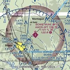
| Sectional chart |
|---|
|
| Airport distance calculator |
|---|
|
|
| Sunrise and sunset |
|---|
|
Times for 21-Jul-2026
| | Local
(UTC-5) | | Zulu
(UTC) |
|---|
| Morning civil twilight | | 06:09 | | 11:09 |
| Sunrise | | 06:37 | | 11:37 |
| Sunset | | 20:38 | | 01:38 |
| Evening civil twilight | | 21:06 | | 02:06 |
|
| Current date and time |
|---|
| Zulu (UTC) | 22-Jul-2026 01:05:48 |
|---|
| Local (UTC-5) | 21-Jul-2026 20:05:48 |
|---|
|
| METAR |
|---|
| K0F2 | 220055Z AUTO 12005KT 10SM CLR 36/20 A2988 RMK AO2 T03600204
|
|
| TAF |
|---|
KSPS
43nm NW | 211720Z 2118/2218 29006KT P6SM SKC FM220000 13006KT P6SM SKC
|
KAFW
45nm SE | 212045Z 2121/2218 VRB05KT P6SM SCT070 FM220200 18005KT P6SM FEW250 FM221200 01005KT P6SM FEW250
|
|
| NOTAMs |
|---|
NOTAMs are issued by the DoD/FAA and will open in a separate window not controlled by AirNav.
|
|


