FAA INFORMATION EFFECTIVE 22 JANUARY 2026
Location
| FAA Identifier: | XBP |
| Lat/Long: | 33-10-26.2550N 097-49-42.3377W
33-10.437583N 097-49.705628W
33.1739597,-97.8284271
(estimated) |
| Elevation: | 863.7 ft. / 263.3 m (surveyed) |
| Variation: | 05E (2010) |
| From city: | 4 miles SW of BRIDGEPORT, TX |
| Time zone: | UTC -6 (UTC -5 during Daylight Saving Time) |
| Zip code: | 76426 |
Airport Operations
| Airport use: | Open to the public |
| Activation date: | 01/1970 |
| Control tower: | no |
| ARTCC: | FORT WORTH CENTER |
| FSS: | FORT WORTH FLIGHT SERVICE STATION |
| NOTAMs facility: | XBP (NOTAM-D service available) |
| Attendance: | MON-FRI 0800-1200 |
| Wind indicator: | lighted |
| Segmented circle: | yes |
| Lights: | SS-SR |
| Beacon: | white-green (lighted land airport)
Operates sunset to sunrise. |
Airport Communications
| CTAF/UNICOM: | 123.0 |
| WX AWOS-3PT: | 119.225 (940-683-8027) |
| WX AWOS-3 at LUD (13 nm E): | 118.225 (940-627-2365) |
- APCH/DEP CTL SVC PRVDD BY FORT WORTH ARTCC (ZFW) ON FREQS 127.0/360.6 (MINERAL WELLS RCAG).
Nearby radio navigation aids
| VOR radial/distance | | VOR name | | Freq | | Var |
|---|
| UKWr175/21.7 | | BOWIE VORTAC | | 117.15 | | 06E |
| MQPr009/28.2 | | MILLSAP VORTAC | | 117.70 | | 09E |
| FUZr292/36.8 | | RANGER VORTAC | | 115.70 | | 06E |
Airport Services
| Fuel available: | 100LL JET-A+
100LL:FUEL 24 HRS SELF SVC.
A+:JET A SELF-SERVE. FULL SERV AVBL ON REQ 940-399-9504. CALL IN FEE. |
| Parking: | hangars and tiedowns |
| Airframe service: | MAJOR |
| Powerplant service: | MAJOR |
| Bottled oxygen: | NONE |
| Bulk oxygen: | NONE |
Runway Information
Runway 18/36
| Dimensions: | 5005 x 75 ft. / 1526 x 23 m |
| Surface: | asphalt, in fair condition |
| Weight bearing capacity: | |
| Runway edge lights: | medium intensity |
| RUNWAY 18 | | RUNWAY 36 |
| Latitude: | 33-10.850107N | | 33-10.025060N |
| Longitude: | 097-49.695330W | | 097-49.715927W |
| Elevation: | 809.2 ft. | | 863.7 ft. |
| Traffic pattern: | left | | left |
| Runway heading: | 176 magnetic, 181 true | | 356 magnetic, 001 true |
| Markings: | nonprecision, in fair condition | | nonprecision, in fair condition |
| Visual slope indicator: | 2-light PAPI on left (3.00 degrees glide path) | | 2-light PAPI on left (3.50 degrees glide path) |
| Touchdown point: | yes, no lights | | yes, no lights |
| Obstructions: | 40 ft. tree, 201 ft. from runway, 225 ft. left of centerline, 1:1 slope to clear
25-40 FT TREES 0-199 FT DSTC 225 FT L. | | none
13 FT TREES, 112 FT DSTC, 248 FT L. |
Airport Ownership and Management from official FAA records
| Ownership: | Publicly-owned |
| Owner: | CITY OF BRIDGEPORT
900 THOMPSON STREET
BRIDGEPORT, TX 76426
Phone 940-683-3400 |
| Manager: | FABIO LABRADA
900 THOMPSON STREET, P O BOX 1254
DECATUR, TX 76234
Phone 940-683-3435 |
Additional Remarks
| - | DEER ON & INVOF ARPT. |
| - | FOR CD CTC FORT WORTH ARTCC AT 817-858-7584. |
Instrument Procedures
NOTE: All procedures below are presented as PDF files. If you need a reader for these files, you should download the free Adobe Reader.NOT FOR NAVIGATION. Please procure official charts for flight.
FAA instrument procedures published for use from 22 January 2026 at 0901Z to 19 February 2026 at 0900z.
IAPs - Instrument Approach Procedures |
|---|
| RNAV (GPS) RWY 18 | |
download (243KB) |
| VOR/DME RWY 18 | |
download (187KB) |
| NOTE: Special Alternate Minimums apply | |
download (47KB) |
| NOTE: Special Take-Off Minimums/Departure Procedures apply | |
download (113KB) |
Other nearby airports with instrument procedures:
KLUD - Decatur Municipal Airport (13 nm E)
4T2 - Kenneth Copeland Airport (21 nm SE)
0F2 - Bowie Municipal Airport (26 nm N)
KMWL - Mineral Wells Regional Airport (26 nm SW)
KWEA - Parker County Airport (27 nm S)
|
|

Road maps at:
MapQuest
Bing
Google
| Aerial photo |
|---|
WARNING: Photo may not be current or correct
 Photo taken 28-Jul-2007
Do you have a better or more recent aerial photo of Bridgeport Municipal Airport that you would like to share? If so, please send us your photo.
|
| Sectional chart |
|---|
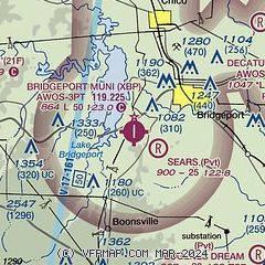
|
| Airport distance calculator |
|---|
|
|
| Sunrise and sunset |
|---|
|
Times for 16-Feb-2026
| | Local
(UTC-6) | | Zulu
(UTC) |
|---|
| Morning civil twilight | | 06:50 | | 12:50 |
| Sunrise | | 07:15 | | 13:15 |
| Sunset | | 18:16 | | 00:16 |
| Evening civil twilight | | 18:41 | | 00:41 |
|
| Current date and time |
|---|
| Zulu (UTC) | 17-Feb-2026 01:59:52 |
|---|
| Local (UTC-6) | 16-Feb-2026 19:59:52 |
|---|
|
| METAR |
|---|
| KXBP | 170130Z AUTO 15009G15KT 10SM CLR 19/11 A2995 RMK AO2 T01890105
|
KLUD
13nm E | 118.22 940-927-2365
170135Z AUTO 14007KT 10SM CLR 18/11 A2994 RMK AO2 T01790105
|
|
| TAF |
|---|
KAFW
29nm SE | 162100Z 1621/1718 17012KT P6SM SKC FM171500 17014KT P6SM SCT015 FM171700 18020G30KT P6SM FEW015 SCT250
|
KFTW
31nm SE | 162100Z 1621/1718 17012KT P6SM SKC FM171500 17014KT P6SM SCT015 FM171700 18020G30KT P6SM FEW015 SCT250
|
|
| NOTAMs |
|---|
NOTAMs are issued by the DoD/FAA and will open in a separate window not controlled by AirNav.
|
|


