FAA INFORMATION EFFECTIVE 14 MAY 2026
Location
| FAA Identifier: | FTW |
| Lat/Long: | 32-49-11.1730N 097-21-44.8200W
32-49.186217N 097-21.747000W
32.8197703,-97.3624500
(estimated) |
| Elevation: | 710.1 ft. / 216.4 m (surveyed) |
| Variation: | 08E (1975) |
| From city: | 5 miles N of FORT WORTH, TX |
| Time zone: | UTC -5 (UTC -6 during Standard Time) |
| Zip code: | 76106 |
Airport Operations
| Airport use: | Open to the public |
| Activation date: | 02/1938 |
| Control tower: | yes |
| ARTCC: | FORT WORTH CENTER |
| FSS: | FORT WORTH FLIGHT SERVICE STATION |
| NOTAMs facility: | FTW (NOTAM-D service available) |
| Attendance: | CONTINUOUS |
| Pattern altitude: | TPA - RWY 17/35 R/W 1300(590) AGL, F/W 1500(790) AGL, RWY 16/34 1500(790) AGL, JETS 2000(1290) AGL. |
| Wind indicator: | lighted |
| Segmented circle: | yes |
| Lights: | SS-SR |
| Beacon: | white-green (lighted land airport)
Operates sunset to sunrise. |
| Fire and rescue: | ARFF index A |
| International operations: | US CUSTOMS USER FEE ARPT. |
Airport Communications
| ATIS: | 120.7 |
| WX ASOS: | PHONE 817-740-3346 |
| MEACHAM GROUND: | 121.9 |
| MEACHAM TOWER: | 118.3 257.8 |
| LONE STAR APPROACH: | 118.1 ;NORTH 135.975 ;SOUTH |
| LONE STAR DEPARTURE: | 118.1 ;NORTH 135.975 ;SOUTH |
| CLEARANCE DELIVERY: | 124.65 |
| BOTCH DP: | 118.1 118.1 ;NORTH 135.975 ;SOUTH |
| DALLAS AREA DP: | 118.1 ;NORTH 135.975 ;SOUTH |
| DODJE STAR: | 125.2 125.9 |
| EMERG: | 121.5 243.0 |
| GARLAND DP: | 118.1 ;NORTH 135.975 ;SOUTH |
| JOE POOL DP: | 135.975 |
| LIKES STAR: | 125.8 ;SOUTH 135.975 ;NORTH |
| MOTZA STAR: | 118.1 ;SOUTH 125.8 ;NORTH |
| NANDR RNAV DP: | 118.1 ;RWY 34, 35 135.975 ;RWY 16, 17 |
| REEKO STAR: | 125.2 |
| SASIE STAR: | 124.3 |
| TRUUK RNAV STAR: | 124.3 |
| WESAT STAR: | 118.1 ;SOUTH 125.8 ;NORTH |
| WX ASOS at AFW (10 nm N): | PHONE 817-491-6188 |
| WX AWOS-3PT at FWS (16 nm S): | 120.025 (817-426-4172) |
| WX ASOS at GKY (16 nm SE): | 127.375 (817-557-0251) |
| WX ASOS at DFW (17 nm E): | PHONE 214-600-7784 |
| WX AWOS-3P at GPM (17 nm SE): | 118.475 (972-606-1433) |
- SAID IN USE. OPERATE TRANSPONDERS WITH ALTITUDE REPORTING MODE AND ADS-B (IF EQUIPPED) ENABLED ON ALL AIRPORT SURFACES.
Nearby radio navigation aids
| VOR radial/distance | | VOR name | | Freq | | Var |
|---|
| FUZr240/10.1 | | RANGER VORTAC | | 115.70 | | 06E |
| TTTr254/16.5 | | MAVERICK VOR/DME | | 113.10 | | 06E |
| CVEr254/23.5 | | COWBOY VOR/DME | | 116.20 | | 06E |
| MQPr071/32.5 | | MILLSAP VORTAC | | 117.70 | | 09E |
| NDB name | | Hdg/Dist | | Freq | | Var | | ID |
|---|
| MUFIN | | 165/4.4 | | 365 | | 08E | | FT | ..-. - |
Airport Services
| Fuel available: | 100LL JET-A JET-A1+ |
| Parking: | hangars and tiedowns |
| Airframe service: | MAJOR |
| Powerplant service: | MAJOR |
| Bottled oxygen: | HIGH |
| Bulk oxygen: | HIGH |
Runway Information
Runway 16/34
| Dimensions: | 7502 x 150 ft. / 2287 x 46 m |
| Surface: | concrete/grooved, in good condition |
| Weight bearing capacity: | | Single wheel: | 80.0 | | Double wheel: | 100.0 | | Double tandem: | 190.0 | | Dual double tandem: | 350.0 |
|
| Runway edge lights: | high intensity |
| RUNWAY 16 | | RUNWAY 34 |
| Latitude: | 32-49.810627N | | 32-48.585940N |
| Longitude: | 097-21.749197W | | 097-21.542867W |
| Elevation: | 710.1 ft. | | 674.0 ft. |
| Traffic pattern: | left | | right |
| Runway heading: | 164 magnetic, 172 true | | 344 magnetic, 352 true |
| Declared distances: | TORA:7502 TODA:7502 ASDA:7502 LDA:7502 | | TORA:7502 TODA:7502 ASDA:7306 LDA:7306 |
| Markings: | precision, in good condition | | precision, in good condition |
| Visual slope indicator: | 4-light PAPI on right (3.00 degrees glide path) | | |
| RVR equipment: | touchdown | | rollout |
| Approach lights: | MALSR: 1,400 foot medium intensity approach lighting system with runway alignment indicator lights | | MALS: 1,400 foot medium intensity approach lighting system |
| Runway end identifier lights: | no | | no |
| Touchdown point: | yes, no lights | | yes, no lights |
| Instrument approach: | ILS/DME | | ILS/DME |
| Obstructions: | 31 ft. pole, 1450 ft. from runway, 625 ft. left of centerline, 40:1 slope to clear | | none |
Runway 17/35
| Dimensions: | 4005 x 75 ft. / 1221 x 23 m |
| Surface: | asphalt, in excellent condition |
| Weight bearing capacity: | | Single wheel: | 25.0 | | Double wheel: | 45.0 |
|
| Runway edge lights: | medium intensity |
| Operational restrictions: | RWY 17/35 NOT AVBL FOR PART 121/PART 380 OPS WITH SKED PAX CARRYING OPS MORE THAN 9 PAX SEATS AND NON-SKED PAX CARRYING OPS MORE THAN 30 PAX SEATS. |
| RUNWAY 17 | | RUNWAY 35 |
| Latitude: | 32-49.490370N | | 32-48.836858N |
| Longitude: | 097-21.991187W | | 097-21.881068W |
| Elevation: | 668.2 ft. | | 667.2 ft. |
| Traffic pattern: | right | | left |
| Runway heading: | 164 magnetic, 172 true | | 344 magnetic, 352 true |
| Markings: | nonprecision, in good condition | | nonprecision, in good condition |
| Visual slope indicator: | 2-light PAPI on left (3.75 degrees glide path) | | 2-light PAPI on left (3.25 degrees glide path) |
| Touchdown point: | yes, no lights | | yes, no lights |
| Obstructions: | 39 ft. berm, lighted, 1361 ft. from runway, 1 ft. right of centerline, 29:1 slope to clear | | none |
Helipad H1
| Dimensions: | 35 x 35 ft. / 11 x 11 m |
| Surface: | concrete, in good condition |
| Latitude: | 32-49.154333N | | |
| Longitude: | 097-21.993833W | | |
| Elevation: | 710.1 ft. | | |
| Traffic pattern: | left | | left |
| Markings: | none, in good condition | | |
Helipad H2
| Dimensions: | 35 x 35 ft. / 11 x 11 m |
| Surface: | concrete, in good condition |
| Latitude: | 32-49.099667N | | |
| Longitude: | 097-21.984500W | | |
| Elevation: | 668.7 ft. | | |
| Traffic pattern: | left | | left |
| Markings: | none, in fair condition | | |
Airport Ownership and Management from official FAA records
| Ownership: | Publicly-owned |
| Owner: | CITY OF FORT WORTH
1000 THROCKMORTON ST.
FORT WORTH, TX 76102-6311
Phone 817-392-5400 |
| Manager: | AARON BARTH
201 AMERICAN CONCOURSE, SUITE 330
FORT WORTH, TX 76106-2749
Phone 817 392-5400 |
Additional Remarks
| A39-16/34 | PCR VALUE: 310/R/C/W/T |
| A39-17/35 | PCR VALUE: 100/F/C/X/T |
| - | TWYS B, B1, C, AND D WEST OF RWY 16/34, M EAST OF TWY A, TWYS H, J, L, L1, S, W, AND TWY G SE 650 FEET CLSD TO ACFT WITH MORE THAN 30 PSGR SEATS. |
| - | RWY 17/35 DESIGNED FOR ACFT WITH WINGSPAN OF 49 FT OR LESS. TWYS B & B1 DESIGNED FOR ACFT WITH WINGSPAN OF LESS THAN 79 FT. RY 16/34 & TWYS A, A1, AND M DESIGNED FOR ACFT WITH WINGSPAN LESS THAN 171 FT. ALL OTHER TWYS DESIGNED FOR ACFT WITH WINGSPAN OF LESS THAN 118 FT. |
| - | H1 & H2 HELIPADS ARE VMC DALGT USE ONLY; NON-MOVEMENT AREA. |
| - | MKD US CUST PRKG SOUTHEAST OF TXL G AND TXL N INTXN. |
| - | HELO SKIDDING OPNS PROHIBITED ON RWY 17/35. IF SKIDDING IS RQRD, COORD WITH ATCT TO USE TWY B. |
| - | PPR FOR ACR OPNS WITH MORE THAN 30 PSGR SEATS - 24 HR NOTICE RQRD - CALL ARPT OPS 817-994-0653. |
| - | ARPT FEES FOR USE OF CUST SVCS WILL BE COLLD IMT UPON LDG BY CITY OF FORT WORTH ARPT OPNS PSNL. |
| - | RWY 17/35 LED LGT CAN APPR BRGTR THAN RWY 16/34; ENSURE COR RWY ALNMT. |
| - | HELS REPOSITIONING BYD IMT PRKG APRON AND UNDER THEIR OWN PWR MUST CTC ATC. |
| - | ARFF INDEX B AVBL ALL USERS WITH 24 HR PPR. |
| - | BIRDS ON & INVOF ARPT. |
Instrument Procedures
NOTE: All procedures below are presented as PDF files. If you need a reader for these files, you should download the free Adobe Reader.NOT FOR NAVIGATION. Please procure official charts for flight.
FAA instrument procedures published for use from 14 May 2026 at 0901Z to 11 June 2026 at 0900Z.
STARs - Standard Terminal Arrivals |
|---|
| DODJE SIX | |
2 pages:
[1] [2] (675KB) |
| LIKES FOUR (RNAV) | |
download (193KB) |
| MOTZA ONE | |
2 pages:
[1] [2] (426KB) |
| REEKO THREE (RNAV) | |
download (215KB) |
| SASIE EIGHT | |
2 pages:
[1] [2] (439KB) |
| TRUUK THREE (RNAV) | |
download (199KB) |
| WESAT THREE (RNAV) | |
download (211KB) |
IAPs - Instrument Approach Procedures |
|---|
| ILS OR LOC RWY 16 | |
download (234KB) |
| ILS OR LOC RWY 34 | |
download (227KB) |
| RNAV (GPS) RWY 16 | |
download (218KB) |
| RNAV (GPS) RWY 34 | |
download (223KB) |
| NOTE: Special Alternate Minimums apply | |
download (118KB) |
Departure Procedures |
|---|
| BOTCH TWO (RNAV) **NEW** | |
2 pages:
[1] [2] (459KB) |
| DALLAS FOUR | |
2 pages:
[1] [2] (392KB) |
| GARLAND SIX | |
2 pages:
[1] [2] (388KB) |
| JOE POOL EIGHT | |
2 pages:
[1] [2] (500KB) |
| KINGDOM FIVE | |
2 pages:
[1] [2] (413KB) |
| KUSSO THREE (RNAV) **NEW** | |
2 pages:
[1] [2] (392KB) |
| NANDR FOUR (RNAV) **NEW** | |
2 pages:
[1] [2] (397KB) |
| TEXOMA FIVE | |
2 pages:
[1] [2] (493KB) |
| WORTH ONE | |
2 pages:
[1] [2] (431KB) |
| NOTE: Special Take-Off Minimums/Departure Procedures apply | |
download (305KB) |
Other nearby airports with instrument procedures:
KNFW - Fort Worth Naval Air Station JRB (Carswell Field) Airport (5 nm SW)
KAFW - Perot Field/Fort Worth Alliance Airport (10 nm N)
4T2 - Kenneth Copeland Airport (12 nm NW)
KFWS - Fort Worth Spinks Airport (16 nm S)
KGKY - Arlington Municipal Airport (16 nm SE)
KWEA - Parker County Airport (17 nm W)
KDFW - Dallas-Fort Worth International Airport (17 nm E)
KGPM - Grand Prairie Municipal Airport (17 nm SE)
50F - Bourland Field Airport (18 nm SW)
|
|

Road maps at:
MapQuest
Bing
Google
| Aerial photo |
|---|
WARNING: Photo may not be current or correct
 Photo by Gary Chambers
Photo taken 13-Jan-2005
looking northwest
Photo by Gary Chambers
Photo taken 13-Jan-2005
looking northwest
Do you have a better or more recent aerial photo of Fort Worth Meacham International Airport that you would like to share? If so, please send us your photo.
|
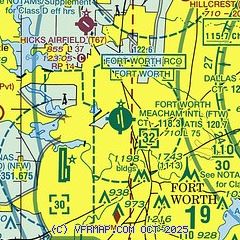
| Sectional chart |
|---|
|
CAUTION: Diagram may not be current
 Download PDF
of official airport diagram from the FAA
| Airport distance calculator |
|---|
|
|
| Sunrise and sunset |
|---|
|
Times for 08-Jun-2026
| | Local
(UTC-5) | | Zulu
(UTC) |
|---|
| Morning civil twilight | | 05:53 | | 10:53 |
| Sunrise | | 06:22 | | 11:22 |
| Sunset | | 20:35 | | 01:35 |
| Evening civil twilight | | 21:04 | | 02:04 |
|
| Current date and time |
|---|
| Zulu (UTC) | 08-Jun-2026 18:28:34 |
|---|
| Local (UTC-5) | 08-Jun-2026 13:28:34 |
|---|
|
| METAR |
|---|
| KFTW | 081753Z 19013KT 10SM FEW036 BKN045 32/23 A2992 RMK AO2 SLP122 T03220228 10322 20256 50006 $
|
KNFW
5nm SW | 081752Z 19012G20KT 10SM SCT039 32/23 A2993 RMK AO2 PK WND 19027/1654 SLP118 T03170228 10317 20256 50004 VISNO S $
|
KAFW
9nm N | 081753Z 19018G25KT 10SM BKN036 BKN044 31/22 A2993 RMK AO2 SLP116 T03110222 10311 20256 51008 $
|
KFWS
16nm S | 081749Z 20011G16KT 10SM BKN037 OVC045 32/24 A2994
|
KGKY
16nm SE | 081753Z 20016KT 10SM FEW035 BKN046 31/23 A2993 RMK AO2 SLP125 T03110233 10317 20256 50002 $
|
KGPM
17nm SE | 081815Z AUTO 17011KT 10SM SCT035 BKN046 32/23 A2995 RMK AO2 T03190226
|
KDFW
18nm E | 081753Z 18011KT 10SM SCT036 BKN046 31/23 A2992 RMK AO2 SLP121 T03110228 10317 20261 50004 $
|
|
| TAF |
|---|
| KFTW | 081727Z 0818/0918 17015G22KT P6SM SCT040 FM091100 17010KT P6SM BKN015 FM091600 18012G20KT P6SM SCT040
|
KNFW
5nm SW | 081500Z 0815/0915 19015G22KT 9999 SCT030 QNH2986INS TEMPO 0815/0816 BKN028 FM081800 19018G25KT 9999 SCT050 BKN250 QNH2984INS FM090400 19012G18KT 9999 SCT022 BKN200 QNH2990INS FM090800 19012KT 9999 BKN018 BKN150 QNH2992INS TX34/0820Z TN25/0910Z FN20046
|
KAFW
9nm N | 081727Z 0818/0918 18018G25KT P6SM SCT035 FM090300 18015G20KT P6SM FEW045 FM091100 18012KT P6SM BKN020 FM091600 18015KT P6SM SCT040
|
KGKY
16nm SE | 081727Z 0818/0918 18014G24KT P6SM SCT040 FM090200 15010KT P6SM FEW045 FM091100 18010KT P6SM BKN020 FM091600 18012G20KT P6SM SCT040
|
KDFW
18nm E | 081727Z 0818/0924 17017G24KT P6SM SCT035 BKN045 FM090300 17015KT P6SM FEW045 FM091100 17010KT P6SM BKN015 FM091600 18014G20KT P6SM SCT040
|
|
| NOTAMs |
|---|
NOTAMs are issued by the DoD/FAA and will open in a separate window not controlled by AirNav.
|
|


