FAA INFORMATION EFFECTIVE 16 APRIL 2026
Location
| FAA Identifier: | GPM |
| Lat/Long: | 32-41-55.6000N 097-02-48.9000W
32-41.926667N 097-02.815000W
32.6987778,-97.0469167
(estimated) |
| Elevation: | 590 ft. / 180 m (estimated) |
| Variation: | 03E (2025) |
| From city: | 4 miles SW of GRAND PRAIRIE, TX |
| Time zone: | UTC -5 (UTC -6 during Standard Time) |
| Zip code: | 75052 |
Airport Operations
| Airport use: | Open to the public |
| Activation date: | 06/1968 |
| Control tower: | yes |
| ARTCC: | FORT WORTH CENTER |
| FSS: | FORT WORTH FLIGHT SERVICE STATION |
| NOTAMs facility: | GPM (NOTAM-D service available) |
| Attendance: | MARCH-OCTOBER MON-SAT 0800-2000, NOVEMBER-FEBRUARY MON-SAT 0800-2000, ALL SUN 0800-1900 |
| Pattern altitude: | 1202 ft. MSL
TPA: 812 FT AGL FIXED WING, 612 FT AGL ROTARY WING. |
| Wind indicator: | lighted |
| Segmented circle: | yes |
| Lights: | MIRL RWY 18/36 PRESET LOW INTST; TO INCR INTST & ACTVT REIL RWY 36 AFT ATCT CLSD - CTAF. |
| Beacon: | white-green (lighted land airport)
Operates sunset to sunrise. |
Airport Communications
| CTAF: | 128.55 |
| UNICOM: | 123.075 |
| WX AWOS-3P: | 118.475 (972-606-1433) |
| GRAND PRAIRIE GROUND: | 121.15 [0700-2100 DALGT TIME; 0800-1800 STANDARD TIME] |
| GRAND PRAIRIE TOWER: | 128.55 [0700-2100 DALGT TIME; 0800-1800 STANDARD TIME] |
| LONE STAR APPROACH: | 135.975 |
| LONE STAR DEPARTURE: | 135.975 |
| BOTCH DP: | 135.975 |
| DALLAS AREA DP: | 135.975 |
| DODJE STAR: | 125.2 125.9 |
| GARLAND DP: | 135.975 |
| JOE POOL DP: | 135.975 |
| LIKES STAR: | 125.8 ;SOUTH 135.975 ;NORTH |
| MOTZA STAR: | 118.1 ;SOUTH 125.8 ;NORTH |
| NANDR RNAV DP: | 135.975 |
| REEKO STAR: | 125.2 |
| SASIE STAR: | 124.3 |
| SWVAY STAR: | 135.975 |
| TRUUK RNAV STAR: | 124.3 |
| WESAT STAR: | 118.1 ;SOUTH 125.8 ;NORTH |
| WX ASOS at GKY (3 nm SW): | 127.375 (817-557-0251) |
| WX ASOS at RBD (9 nm E): | PHONE 214-330-5317 |
| WX ASOS at DFW (12 nm N): | PHONE 214-600-7784 |
| WX AWOS-3 at 49T (13 nm E): | 135.425 (214-670-1243) |
| WX ASOS at DAL (13 nm NE): | PHONE 214-353-1551 |
| WX AWOS-3PT at FWS (15 nm SW): | 120.025 (817-426-4172) |
| WX AWOS-3P at JWY (16 nm SE): | 119.575 (972-227-0471) |
| WX ASOS at FTW (17 nm NW): | PHONE 817-740-3346 |
| WX AWOS-3PT at LNC (18 nm SE): | 118.975 (972-227-0471) |
| WX AWOS-3PT at ADS (19 nm NE): | PHONE 972-386-4855 |
Nearby radio navigation aids
| VOR radial/distance | | VOR name | | Freq | | Var |
|---|
| TTTr176/10.2 | | MAVERICK VOR/DME | | 113.10 | | 06E |
| FUZr144/13.2 | | RANGER VORTAC | | 115.70 | | 06E |
| CVEr206/13.6 | | COWBOY VOR/DME | | 116.20 | | 06E |
Airport Services
| Fuel available: | 100LL JET-A |
| Parking: | hangars and tiedowns |
| Airframe service: | MAJOR |
| Powerplant service: | MAJOR |
| Bottled oxygen: | NONE |
| Bulk oxygen: | NONE |
Runway Information
Runway 18/36
| Dimensions: | 4001 x 75 ft. / 1220 x 23 m |
| Surface: | concrete, in good condition |
| Weight bearing capacity: | |
| Runway edge lights: | medium intensity |
| RUNWAY 18 | | RUNWAY 36 |
| Latitude: | 32-42.256870N | | 32-41.597050N |
| Longitude: | 097-02.812673W | | 097-02.817323W |
| Elevation: | 581.5 ft. | | 572.8 ft. |
| Traffic pattern: | left | | right |
| Runway heading: | 177 magnetic, 180 true | | 357 magnetic, 000 true |
| Markings: | nonprecision, in good condition | | nonprecision, in good condition |
| Visual slope indicator: | 4-box VASI on left (3.00 degrees glide path) | | 4-box VASI on left (4.00 degrees glide path) |
| Runway end identifier lights: | | | yes |
| Touchdown point: | yes, no lights | | yes, no lights |
| Obstructions: | 20 ft. bldg, 790 ft. from runway, 29:1 slope to clear | | 24 ft. road, 600 ft. from runway, 310 ft. left and right of centerline, 16:1 slope to clear |
Helipad H1
| Dimensions: | 50 x 50 ft. / 15 x 15 m |
| Surface: | concrete, in good condition |
| Runway edge lights: | PERI |
| Latitude: | 32-42.130000N | | |
| Longitude: | 097-02.870000W | | |
| Elevation: | 590.0 ft. | | |
| Traffic pattern: | left | | left |
| Markings: | basic, in fair condition | | |
Airport Ownership and Management from official FAA records
| Ownership: | Publicly-owned |
| Owner: | CITY OF GRAND PRAIRIE
300 W MAIN STREET, P.O. BOX 534045
GRAND PRAIRIE, TX 75053-4045
Phone 972-237-8015 |
| Manager: | MARK DIVITA
3116 S GT SOUTHWEST PKWY
GRAND PRAIRIE, TX 75052-7238
Phone 972-237-7591 |
Additional Remarks
| - | EXTSV HEL TFC WEST SIDE OF ARPT. |
| - | FOR CD WHEN ATCT IS CLSD CTC LONE STAR APCH AT 972-615-2799. |
| - | WEST GRASS FOR ROTARY WING USE ONLY. |
| - | NO ADS-B BILLING OR LDG FEES. GA TSNT RAMP FREE FOR SHORT TERM ONLY. |
| - | 165 FT. WATER TWR, 1/4 MILE WEST OF RWY |
Instrument Procedures
NOTE: All procedures below are presented as PDF files. If you need a reader for these files, you should download the free Adobe Reader.NOT FOR NAVIGATION. Please procure official charts for flight.
FAA instrument procedures published for use from 16 April 2026 at 0901Z to 14 May 2026 at 0900Z.
STARs - Standard Terminal Arrivals |
|---|
| DODJE SIX | |
2 pages:
[1] [2] (675KB) |
| MOTZA ONE | |
2 pages:
[1] [2] (426KB) |
| REEKO THREE (RNAV) | |
download (215KB) |
| SASIE EIGHT | |
2 pages:
[1] [2] (438KB) |
| SWVAY FOUR (RNAV) | |
download (239KB) |
| TRUUK THREE (RNAV) | |
download (199KB) |
| WESAT THREE (RNAV) | |
download (210KB) |
IAPs - Instrument Approach Procedures |
|---|
| RNAV (GPS) RWY 36 | |
download (157KB) |
| VOR RWY 36 | |
download (186KB) |
| NOTE: Special Alternate Minimums apply | |
download (116KB) |
Departure Procedures |
|---|
| BOTCH ONE (RNAV) | |
2 pages:
[1] [2] (354KB) |
| DALLAS FOUR | |
2 pages:
[1] [2] (330KB) |
| GARLAND SIX | |
2 pages:
[1] [2] (330KB) |
| JOE POOL EIGHT | |
2 pages:
[1] [2] (448KB) |
| KINGDOM FIVE | |
2 pages:
[1] [2] (353KB) |
| KUSSO TWO (RNAV) | |
2 pages:
[1] [2] (325KB) |
| NANDR THREE (RNAV) | |
2 pages:
[1] [2] (327KB) |
| TEXOMA FIVE | |
2 pages:
[1] [2] (438KB) |
| WORTH ONE | |
2 pages:
[1] [2] (417KB) |
| NOTE: Special Take-Off Minimums/Departure Procedures apply | |
download (299KB) |
Other nearby airports with instrument procedures:
KGKY - Arlington Municipal Airport (3 nm SW)
KRBD - Dallas Executive Airport (9 nm E)
KDFW - Dallas-Fort Worth International Airport (12 nm N)
KDAL - Dallas Love Field Airport (13 nm NE)
KFWS - Fort Worth Spinks Airport (15 nm SW)
KJWY - Mid-Way Regional Airport (16 nm SE)
KFTW - Fort Worth Meacham International Airport (17 nm NW)
KLNC - Lancaster Regional Airport (18 nm SE)
KADS - Addison Airport (19 nm NE)
|
|

Road maps at:
MapQuest
Bing
Google
| Aerial photo |
|---|
WARNING: Photo may not be current or correct
 Photo taken 16-Nov-2018
looking north-northeast.
Photo taken 16-Nov-2018
looking north-northeast.
Do you have a better or more recent aerial photo of Grand Prairie Municipal Airport that you would like to share? If so, please send us your photo.
|
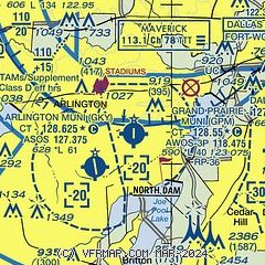
| Sectional chart |
|---|
|
CAUTION: Diagram may not be current
 Download PDF
of official airport diagram from the FAA
| Airport distance calculator |
|---|
|
|
| Sunrise and sunset |
|---|
|
Times for 26-Apr-2026
| | Local
(UTC-5) | | Zulu
(UTC) |
|---|
| Morning civil twilight | | 06:21 | | 11:21 |
| Sunrise | | 06:47 | | 11:47 |
| Sunset | | 20:05 | | 01:05 |
| Evening civil twilight | | 20:31 | | 01:31 |
|
| Current date and time |
|---|
| Zulu (UTC) | 26-Apr-2026 05:58:35 |
|---|
| Local (UTC-5) | 26-Apr-2026 00:58:35 |
|---|
|
| METAR |
|---|
| KGPM | 260535Z AUTO 32014G39KT 300V360 1/2SM FG BKN010 OVC016 21/20 A2979 RMK AO2 P0051 T02060203
|
KGKY
3nm SW | 260553Z AUTO 08009G29KT 040V120 10SM -TSRA SCT034 BKN055 OVC080 23/18 A2974 RMK AO2 PK WND 01040/0539 WSHFT 0528 LTG DSNT ALQDS SLP063 P0007 60011 T02330178 10294 20211 403060206 53005 $
|
KRBD
9nm E | 260553Z AUTO 08011G20KT 5SM +TSRA SCT070 OVC085 24/22 A2974 RMK AO2 LTG DSNT SE AND W AND NW RAB22 TSE29B32 SLP061 P0013 60013 T02440217 10278 20244 403000211 51015
|
KDFW
12nm N | 260553Z 17017G46KT 7SM TSRA SCT050CB BKN080 BKN120 OVC200 22/18 A2969 RMK AO2 PK WND 18046/0544 SLP045 CONS LTGICCCCG ALQDS TS ALQDS MOV SE P0007 60009 T02220178 10283 20222 403110194 50005
|
KDAL
13nm NE | 260553Z 16021G30KT 4SM TSRA SCT050CB BKN070 OVC100 25/22 A2969 RMK AO2 PK WND 16032/0535 PRESFR SLP045 CONS LTGICCCCGCA TS ALQDS MOV E P0012 60012 T02500217 10289 20244 403060217 58001
|
KFWS
15nm SW | 260555Z AUTO 01017G21KT 10SM TS BKN025 BKN033 22/20 A2978 RMK AO2 TSB0537 CIG 022V028 60001 T02220201 10284 20214 403050158 53034 $
|
KJWY
16nm SE | 260555Z AUTO 08007KT 050V120 7SM -RA VCTS BKN023 25/22 A2976 RMK AO2 RAE0514B0530 P0000 60000 T02530218 10290 20241 403030213 53016
|
KFTW
18nm NW | 260553Z 12019G29KT 7SM -TSRA BKN014 18/17 A2970 RMK AO2 PK WND 07032/0517 WSHFT 0535 LTG DSNT ALQDS PRESFR SLP049 P0076 60257 T01830167 10283 20183 403110183 50016 $
|
KADS
20nm NE | 260535Z AUTO 18010G16KT 150V210 8SM VCTS FEW055 BKN075 OVC085 27/22 A2971 RMK AO2 LTG DSNT ALQDS PRESRR
|
|
| TAF |
|---|
KGKY
3nm SW | 260410Z 2604/2624 12010KT P6SM -TSRA BKN040CB TEMPO 2604/2606 2SM +TSRA FM260600 12013KT P6SM SCT035 SCT200 FM261100 16011KT P6SM BKN018 FM261800 21013KT P6SM SCT035 BKN200
|
KDFW
12nm N | 260410Z 2604/2706 12011KT P6SM -TSRA BKN050CB TEMPO 2604/2605 4SM TSRA FM260600 13013KT P6SM SCT035 SCT200 FM261100 16011KT P6SM BKN018 FM261800 21013KT P6SM SCT035 BKN200
|
KDAL
13nm NE | 260410Z 2604/2624 13010KT P6SM -TSRA BKN050CB FM260600 14013KT P6SM SCT035 SCT200 FM261100 16011KT P6SM BKN018 FM261800 21013KT P6SM SCT035 BKN200
|
KFTW
18nm NW | 260410Z 2604/2624 12015KT 5SM TSRA BKN040CB TEMPO 2604/2605 1SM +TSRA BKN030CB FM260600 13013KT P6SM SCT035 SCT200 FM261100 16011KT P6SM BKN018 FM261800 21013KT P6SM SCT035 BKN200
|
|
| NOTAMs |
|---|
NOTAMs are issued by the DoD/FAA and will open in a separate window not controlled by AirNav.
|
|


