FAA INFORMATION EFFECTIVE 09 JULY 2026
Location
| FAA Identifier: | RBD |
| Lat/Long: | 32-40-52.7000N 096-52-07.6000W
32-40.878333N 096-52.126667W
32.6813056,-96.8687778
(estimated) |
| Elevation: | 660.5 ft. / 201 m (estimated) |
| Variation: | 06E (1990) |
| From city: | 6 miles SW of DALLAS, TX |
| Time zone: | UTC -5 (UTC -6 during Standard Time) |
| Zip code: | 75237 |
Airport Operations
| Airport use: | Open to the public |
| Activation date: | 09/1948 |
| Control tower: | yes |
| ARTCC: | FORT WORTH CENTER |
| FSS: | FORT WORTH FLIGHT SERVICE STATION |
| NOTAMs facility: | RBD (NOTAM-D service available) |
| Attendance: | 0600-2000
ON CALL AFT HRS. |
| Wind indicator: | lighted |
| Segmented circle: | yes |
| Lights: | WHEN ATCT CLSD MIRL RWYS 13/31& 17/35 PRESET LOW INTST; TO INCR INTST ACTVT - CTAF. |
| Beacon: | white-green (lighted land airport)
Operates sunset to sunrise. |
Airport Communications
| CTAF: | 127.25 |
| UNICOM: | 122.95 |
| ATIS: | 126.35 |
| WX ASOS: | PHONE 214-330-5317 |
| EXECUTIVE GROUND: | 119.475 [0700-2100] |
| EXECUTIVE TOWER: | 127.25 [0700-2100] |
| LONE STAR APPROACH: | 125.2 |
| LONE STAR DEPARTURE: | 125.2 |
| CLEARANCE DELIVERY: | 118.625 |
| BOTCH DP: | 125.2 |
| DALLAS AREA DP: | 125.2 |
| DODJE STAR: | 125.2 125.9 |
| EMERG: | 121.5 |
| FINGR STAR: | 124.3 125.275 |
| GARLAND DP: | 125.2 |
| GREGS STAR: | 118.1 |
| HERBZ STAR: | 118.1 |
| JFRYE STAR: | 118.1 |
| JOE POOL DP: | 125.2 |
| NANDR RNAV DP: | 125.2 |
| REEKO STAR: | 125.2 |
| SLANT STAR: | 125.275 |
| SWVAY STAR: | 135.975 |
| WX AWOS-3 at 49T (6 nm NE): | 135.425 (214-670-1243) |
| WX AWOS-3P at GPM (9 nm W): | 118.475 (972-606-1433) |
| WX AWOS-3PT at LNC (10 nm SE): | 118.975 (972-227-0471) |
| WX ASOS at DAL (10 nm N): | PHONE 214-353-1551 |
| WX ASOS at GKY (11 nm W): | 127.375 (817-557-0251) |
| WX AWOS-3P at JWY (14 nm S): | 119.575 (972-227-0471) |
| WX ASOS at DFW (16 nm NW): | PHONE 214-600-7784 |
| WX AWOS-3PT at ADS (17 nm N): | PHONE 972-386-4855 |
| WX AWOS-3 at HQZ (18 nm E): | 118.175 (972-222-7631) |
Nearby radio navigation aids
| VOR radial/distance | | VOR name | | Freq | | Var |
|---|
| CVEr166/12.7 | | COWBOY VOR/DME | | 116.20 | | 06E |
| TTTr136/14.2 | | MAVERICK VOR/DME | | 113.10 | | 06E |
| FUZr123/20.0 | | RANGER VORTAC | | 115.70 | | 06E |
Airport Services
| Fuel available: | 100LL JET-A
100LL:FUEL AVBL 24 HR. |
| Parking: | hangars and tiedowns |
| Airframe service: | MAJOR |
| Powerplant service: | MAJOR |
| Bulk oxygen: | HIGH/LOW |
Runway Information
Runway 13/31
| Dimensions: | 7136 x 100 ft. / 2175 x 30 m |
| Surface: | concrete/grooved, in excellent condition |
| Weight bearing capacity: | | Single wheel: | 40.0 | | Double wheel: | 90.0 | | Double tandem: | 130.0 |
|
| Runway edge lights: | medium intensity |
| RUNWAY 13 | | RUNWAY 31 |
| Latitude: | 32-41.319333N | | 32-40.485970N |
| Longitude: | 096-52.680167W | | 096-51.697752W |
| Elevation: | 653.4 ft. | | 646.9 ft. |
| Traffic pattern: | left | | left |
| Runway heading: | 129 magnetic, 135 true | | 309 magnetic, 315 true |
| Displaced threshold: | 1085 ft. | | 500 ft. |
| Declared distances: | TORA:6766 TODA:7136 ASDA:6622 LDA:5537 | | TORA:6051 TODA:7136 ASDA:7101 LDA:6601 |
| Markings: | nonprecision, in good condition | | precision, in good condition |
| Visual slope indicator: | 4-light PAPI on left (3.00 degrees glide path) | | 4-light PAPI on right (3.00 degrees glide path) |
| Runway end identifier lights: | yes | | yes |
| Touchdown point: | yes, no lights | | yes, no lights |
| Instrument approach: | | | ILS/DME |
| Obstructions: | 42 ft. trees, 201 ft. from runway, 457 ft. right of centerline
25 FT TREES, 0-199 FT DSTC, 399 FT R. 15 FT CONC WALL, 0 FT DSTC, 385 L. | | 7 ft. road, 547 ft. from runway, 513 ft. right of centerline, 49:1 slope to clear |
Runway 17/35
| Dimensions: | 3800 x 150 ft. / 1158 x 46 m |
| Surface: | concrete, in good condition |
| Weight bearing capacity: | | Single wheel: | 35.0 | | Double wheel: | 60.0 | | Double tandem: | 110.0 |
|
| Runway edge lights: | medium intensity |
| RUNWAY 17 | | RUNWAY 35 |
| Latitude: | 32-41.147942N | | 32-40.521410N |
| Longitude: | 096-52.007498W | | 096-52.009178W |
| Elevation: | 650.6 ft. | | 659.2 ft. |
| Traffic pattern: | left | | left |
| Runway heading: | 174 magnetic, 180 true | | 354 magnetic, 000 true |
| Markings: | nonprecision, in good condition | | nonprecision, in good condition |
| Visual slope indicator: | 4-light PAPI on right (3.00 degrees glide path) | | |
| Runway end identifier lights: | yes | | yes |
| Touchdown point: | yes, no lights | | yes, no lights |
| Obstructions: | 18 ft. trees, 770 ft. from runway, 800 ft. left and right of centerline, 31:1 slope to clear | | none |
Airport Ownership and Management from official FAA records
| Ownership: | Publicly-owned |
| Owner: | CITY OF DALLAS
1500 MARILLA
DALLAS, TX 75201
Phone 214-670-7612 |
| Manager: | RAFAEL GARZA JR.
5303 CHALLENGER DR
DALLAS, TX 75237
Phone 214-670-7612 |
Additional Remarks
| - | BIRDS & WILDLIFE ON & INVOF ARPT. |
Instrument Procedures
NOTE: All procedures below are presented as PDF files. If you need a reader for these files, you should download the free Adobe Reader.NOT FOR NAVIGATION. Please procure official charts for flight.
FAA instrument procedures published for use from 09 July 2026 at 0901Z to 06 August 2026 at 0900Z.
STARs - Standard Terminal Arrivals |
|---|
| DODJE SIX **NEW** | |
2 pages:
[1] [2] (673KB) |
| FINGR ONE **NEW** | |
2 pages:
[1] [2] (428KB) |
| GREGS ONE **NEW** | |
2 pages:
[1] [2] (469KB) |
| HERBZ TWO (RNAV) **NEW** | |
download (281KB) |
| JFRYE FIVE (RNAV) **NEW** | |
download (257KB) |
| REEKO THREE (RNAV) **NEW** | |
download (214KB) |
| SLANT THREE (RNAV) **NEW** | |
download (254KB) |
| SWVAY FOUR (RNAV) **NEW** | |
download (239KB) |
| WESAT THREE (RNAV) **NEW** | |
download (210KB) |
IAPs - Instrument Approach Procedures |
|---|
| ILS OR LOC RWY 31 | |
download (219KB) |
| RNAV (GPS) RWY 17 | |
download (154KB) |
| RNAV (GPS) RWY 31 | |
download (178KB) |
| RNAV (GPS) RWY 35 | |
download (159KB) |
| RNAV (GPS) Y RWY 13 | |
download (174KB) |
| RNAV (GPS) Z RWY 13 | |
download (178KB) |
| VOR RWY 17 | |
download (183KB) |
| NOTE: Special Alternate Minimums apply | |
download (137KB) |
Departure Procedures |
|---|
| BOTCH TWO (RNAV) **NEW** | |
2 pages:
[1] [2] (399KB) |
| DALLAS FOUR | |
2 pages:
[1] [2] (367KB) |
| GARLAND SIX | |
2 pages:
[1] [2] (365KB) |
| JOE POOL EIGHT | |
2 pages:
[1] [2] (485KB) |
| KINGDOM FIVE | |
2 pages:
[1] [2] (390KB) |
| KUSSO THREE (RNAV) **NEW** | |
2 pages:
[1] [2] (365KB) |
| NANDR FOUR (RNAV) **NEW** | |
2 pages:
[1] [2] (365KB) |
| TEXOMA FIVE | |
2 pages:
[1] [2] (474KB) |
| WORTH ONE | |
2 pages:
[1] [2] (455KB) |
| NOTE: Special Take-Off Minimums/Departure Procedures apply | |
download (308KB) |
Other nearby airports with instrument procedures:
KGPM - Grand Prairie Municipal Airport (9 nm W)
KLNC - Lancaster Regional Airport (10 nm SE)
KDAL - Dallas Love Field Airport (10 nm N)
KGKY - Arlington Municipal Airport (11 nm W)
KJWY - Mid-Way Regional Airport (14 nm S)
KDFW - Dallas-Fort Worth International Airport (16 nm NW)
KADS - Addison Airport (17 nm N)
KHQZ - Mesquite Metro Airport (18 nm E)
|
|

Road maps at:
MapQuest
Bing
Google
| Aerial photo |
|---|
WARNING: Photo may not be current or correct
 Photo by Bryant Sivess
Photo taken 07-Dec-2015
looking northwest.
Photo by Bryant Sivess
Photo taken 07-Dec-2015
looking northwest.
Do you have a better or more recent aerial photo of Dallas Executive Airport that you would like to share? If so, please send us your photo.
|
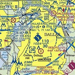
| Sectional chart |
|---|
|
CAUTION: Diagram may not be current
 Download PDF
of official airport diagram from the FAA
| Airport distance calculator |
|---|
|
|
| Sunrise and sunset |
|---|
|
Times for 14-Jul-2026
| | Local
(UTC-5) | | Zulu
(UTC) |
|---|
| Morning civil twilight | | 06:03 | | 11:03 |
| Sunrise | | 06:31 | | 11:31 |
| Sunset | | 20:36 | | 01:36 |
| Evening civil twilight | | 21:04 | | 02:04 |
|
| Current date and time |
|---|
| Zulu (UTC) | 14-Jul-2026 13:55:45 |
|---|
| Local (UTC-5) | 14-Jul-2026 08:55:45 |
|---|
|
| METAR |
|---|
| KRBD | 141341Z 11006KT 10SM SCT010 BKN017 25/23 A3008 RMK AO2 T02500233
|
KGPM
9nm W | 141335Z AUTO 11005KT 10SM OVC009 25/23 A3010 RMK AO2 T02500233
|
KDAL
10nm N | 141253Z 10003KT 10SM SCT007 BKN060 BKN120 26/23 A3007 RMK AO2 SLP175 SCT V BKN TCU DSNT E T02560228
|
KGKY
12nm W | 141324Z 09008KT 10SM BKN011 BKN060 26/23 A3008 RMK AO2 T02560228 $
|
KJWY
14nm S | 141335Z AUTO VRB04KT 9SM OVC005 23/23 A3009 RMK AO2 CIG 005V009 T02350235 $
|
KDFW
15nm NW | 141331Z 09003KT 10SM SCT011 BKN022 OVC055 26/23 A3007 RMK AO2 T02560228 $
|
KADS
17nm N | 141326Z 07006KT 10SM BKN009 26/24 A3009
|
KHQZ
18nm E | 141250Z 10004KT 7SM BKN005 BKN012 24/23 A3008
|
|
| TAF |
|---|
KDAL
10nm N | 141120Z 1412/1512 11005KT P6SM FEW060 TEMPO 1412/1414 BKN015 FM141900 13006KT P6SM VCSH SCT070 TEMPO 1421/1424 4SM -TSRA OVC050CB FM150200 18004KT P6SM FEW240
|
KGKY
12nm W | 141120Z 1412/1512 10006KT P6SM FEW080 TEMPO 1412/1414 BKN015 FM141900 12008KT P6SM VCSH SCT080 TEMPO 1421/1424 4SM -TSRA OVC050CB FM150200 19002KT P6SM FEW190
|
KDFW
15nm NW | 141120Z 1412/1518 11005KT P6SM FEW020 SCT060 TEMPO 1412/1414 BKN015 FM141900 12006KT P6SM VCSH SCT070 TEMPO 1421/1424 4SM -TSRA OVC050CB FM150200 20003KT P6SM FEW210
|
|
| NOTAMs |
|---|
NOTAMs are issued by the DoD/FAA and will open in a separate window not controlled by AirNav.
|
|


