FAA INFORMATION EFFECTIVE 14 MAY 2026
Location
| FAA Identifier: | HQZ |
| Lat/Long: | 32-44-49.0660N 096-31-49.5020W
32-44.817767N 096-31.825033W
32.7469628,-96.5304172
(estimated) |
| Elevation: | 446.5 ft. / 136.1 m (surveyed) |
| Variation: | 03E (2015) |
| From city: | 3 miles E of MESQUITE, TX |
| Time zone: | UTC -5 (UTC -6 during Standard Time) |
| Zip code: | 75181 |
Airport Operations
| Airport use: | Open to the public |
| Activation date: | 08/1976 |
| Control tower: | yes |
| ARTCC: | FORT WORTH CENTER |
| FSS: | FORT WORTH FLIGHT SERVICE STATION |
| NOTAMs facility: | HQZ (NOTAM-D service available) |
| Attendance: | 0800-2000
FOR ATTENDANT AFT HRS CALL 214-244-1959. |
| Wind indicator: | lighted |
| Segmented circle: | yes |
| Lights: | MIRL RWY 18/36 PRESET LOW INTST; TO INCR INTST AND TO ACTVT RLLS RWY 18 & 36; REIL RWY 18 & 36; PAPI RWY 18 & 36 - CTAF. |
| Beacon: | white-green (lighted land airport)
Operates sunset to sunrise. |
Airport Communications
| CTAF: | 120.3 |
| UNICOM: | 123.05 |
| WX AWOS-3: | 118.175 (972-222-7631) |
| MESQUITE GROUND: | 118.85 [0700-2100] |
| MESQUITE TOWER: | 120.3 [0700-2100] |
| LONE STAR APPROACH: | 125.2 |
| LONE STAR DEPARTURE: | 125.2 |
| BOTCH DP: | 125.2 |
| DALLAS AREA DP: | 124.3 ;NORTH 125.2 ;SOUTH |
| EESAT STAR: | 125.025 125.275 |
| FINGR STAR: | 124.3 125.275 |
| GARLAND DP: | 125.2 |
| GREGS STAR: | 118.1 |
| HERBZ STAR: | 118.1 |
| JFRYE STAR: | 118.1 |
| JOE POOL DP: | 125.2 |
| LOADS STAR: | 125.025 125.275 |
| NANDR RNAV DP: | 124.3 ;RWY 36 125.2 ; RWY 18 |
| SLANT STAR: | 125.025 125.275 |
| SWVAY STAR: | 135.975 |
| YEAGR STAR: | 125.2 |
| WX AWOS-3PT at F46 (12 nm NE): | 121.25 (469-991-7392) |
| WX ASOS at TRL (13 nm E): | 119.275 (972-551-1334) |
| WX AWOS-3 at 49T (14 nm W): | 135.425 (214-670-1243) |
| WX AWOS-3PT at LNC (14 nm SW): | 118.975 (972-227-0471) |
| WX ASOS at DAL (17 nm W): | PHONE 214-353-1551 |
| WX ASOS at RBD (18 nm W): | PHONE 214-330-5317 |
Nearby radio navigation aids
| VOR radial/distance | | VOR name | | Freq | | Var |
|---|
| CVEr109/20.7 | | COWBOY VOR/DME | | 116.20 | | 06E |
| TTTr100/26.7 | | MAVERICK VOR/DME | | 113.10 | | 06E |
| FUZr099/33.8 | | RANGER VORTAC | | 115.70 | | 06E |
| CQYr329/37.2 | | CEDAR CREEK VORTAC | | 114.80 | | 06E |
Airport Services
| Fuel available: | 100LL JET-A1+
100LL:SELF-SERVE FUEL AVBL 24 HRS. FULL SERVE DURG ATNDD HRS, ALSO AVBL AFT HRS CALL 214-244-1959. CALL IN FEE. |
| Parking: | hangars and tiedowns |
| Airframe service: | MAJOR |
| Powerplant service: | MAJOR |
| Bottled oxygen: | NONE |
| Bulk oxygen: | HIGH |
Runway Information
Runway 18/36
| Dimensions: | 6000 x 100 ft. / 1829 x 30 m |
| Surface: | concrete, in good condition |
| Weight bearing capacity: | | Single wheel: | 70.0 | | Double wheel: | 100.0 | | Double tandem: | 100.0 |
|
| Runway edge lights: | medium intensity |
| RUNWAY 18 | | RUNWAY 36 |
| Latitude: | 32-45.312350N | | 32-44.323150N |
| Longitude: | 096-31.816150W | | 096-31.834200W |
| Elevation: | 446.0 ft. | | 441.9 ft. |
| Traffic pattern: | left | | left |
| Runway heading: | 178 magnetic, 181 true | | 358 magnetic, 001 true |
| Markings: | precision, in good condition | | precision, in good condition |
| Visual slope indicator: | 4-light PAPI on left (3.00 degrees glide path) | | 4-light PAPI on left (3.00 degrees glide path) |
| Approach lights: | RLLS | | RLLS |
| Runway end identifier lights: | yes | | yes |
| Touchdown point: | yes, no lights | | yes, no lights |
| Instrument approach: | ILS/DME | | |
| Obstructions: | 40 ft. tree, 800 ft. from runway, 460 ft. left of centerline, 15:1 slope to clear
15 FT BRUSH 199 FT DSTC, 490 FT L. | | 8 ft. fence, 230 ft. from runway, 510 ft. right of centerline, 3:1 slope to clear |
Airport Ownership and Management from official FAA records
| Ownership: | Publicly-owned |
| Owner: | CITY OF MESQUITE
1515 N. GALLOWAY AVE., PO BOX 850137
MESQUITE, TX 75185-0137
Phone 972-288-7711 |
| Manager: | SHAWN BEAVER
1340 ARPT BLVD.
MESQUITE, TX 75181
Phone 972-216-4130
SBEAVER@CITYOFMESQUITE.COM |
Additional Remarks
| - | BIRDS, COYOTES, & WILD HOGS ON & INVOF ARPT. |
| - | FOR CD WHEN ATCT IS CLSD CTC LONE STAR APCH AT 972-615-2799. |
Instrument Procedures
NOTE: All procedures below are presented as PDF files. If you need a reader for these files, you should download the free Adobe Reader.NOT FOR NAVIGATION. Please procure official charts for flight.
FAA instrument procedures published for use from 14 May 2026 at 0901Z to 11 June 2026 at 0900Z.
STARs - Standard Terminal Arrivals |
|---|
| EESAT FOUR (RNAV) | |
download (194KB) |
| FINGR ONE | |
2 pages:
[1] [2] (430KB) |
| GREGS ONE | |
2 pages:
[1] [2] (471KB) |
| HERBZ TWO (RNAV) | |
download (282KB) |
| JFRYE FIVE (RNAV) | |
download (258KB) |
| LOADS FOUR (RNAV) | |
download (195KB) |
| SLANT THREE (RNAV) | |
download (255KB) |
| SWVAY FOUR (RNAV) | |
download (240KB) |
| YEAGR FOUR | |
2 pages:
[1] [2] (633KB) |
IAPs - Instrument Approach Procedures |
|---|
| RNAV (GPS) RWY 18 | |
download (229KB) |
| RNAV (GPS) RWY 36 | |
download (215KB) |
| NOTE: Special Alternate Minimums apply | |
download (138KB) |
Departure Procedures |
|---|
| BOTCH TWO (RNAV) **NEW** | |
2 pages:
[1] [2] (346KB) |
| DALLAS FOUR | |
2 pages:
[1] [2] (315KB) |
| GARLAND SIX | |
2 pages:
[1] [2] (312KB) |
| JOE POOL EIGHT | |
2 pages:
[1] [2] (433KB) |
| KINGDOM FIVE | |
2 pages:
[1] [2] (337KB) |
| KUSSO THREE (RNAV) **NEW** | |
2 pages:
[1] [2] (311KB) |
| NANDR FOUR (RNAV) **NEW** | |
2 pages:
[1] [2] (322KB) |
| TEXOMA FIVE | |
2 pages:
[1] [2] (425KB) |
| WORTH ONE | |
2 pages:
[1] [2] (403KB) |
| NOTE: Special Take-Off Minimums/Departure Procedures apply | |
download |
Other nearby airports with instrument procedures:
F46 - Ralph M Hall/Rockwall Municipal Airport (12 nm NE)
KTRL - Terrell Municipal Airport (13 nm E)
KLNC - Lancaster Regional Airport (14 nm SW)
KDAL - Dallas Love Field Airport (17 nm W)
KRBD - Dallas Executive Airport (18 nm W)
|
|

Road maps at:
MapQuest
Bing
Google
| Aerial photo |
|---|
WARNING: Photo may not be current or correct
 Photo taken 16-May-2006
Do you have a better or more recent aerial photo of Mesquite Metro Airport that you would like to share? If so, please send us your photo.
|
| Sectional chart |
|---|
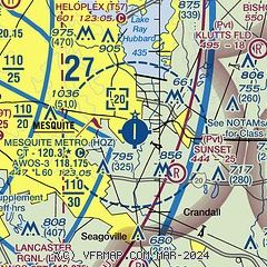
|
CAUTION: Diagram may not be current

| Airport distance calculator |
|---|
|
|
| Sunrise and sunset |
|---|
|
Times for 25-May-2026
| | Local
(UTC-5) | | Zulu
(UTC) |
|---|
| Morning civil twilight | | 05:55 | | 10:55 |
| Sunrise | | 06:22 | | 11:22 |
| Sunset | | 20:24 | | 01:24 |
| Evening civil twilight | | 20:51 | | 01:51 |
|
| Current date and time |
|---|
| Zulu (UTC) | 25-May-2026 19:48:00 |
|---|
| Local (UTC-5) | 25-May-2026 14:48:00 |
|---|
|
| METAR |
|---|
| KHQZ | 251907Z 09016G25KT 10SM TSRA BKN028 29/21 A2996
|
KF46
12nm NE | 251935Z AUTO 07007KT 10SM BKN050 29/18 A2997 RMK AO2 LTG DSNT S AND SW T02930183
|
KTRL
13nm E | 251906Z AUTO 04011KT 10SM VCTS SCT050 31/18 A2995 RMK AO2 LTG DSNT S AND W T03060178 $
|
KDAL
17nm W | 251928Z 14006KT 10SM TS SCT045CB SCT080 BKN120 BKN250 29/20 A2994 RMK AO2 RAE02 TSE14B28 OCNL LTGICCCCG NW-NE AND DSNT E-SE SW TS NW-NE MOV W CB DSNT E-SE SW MOV W TCU ALQDS P0000 T02940200 $
|
KRBD
17nm W | 251900Z 12004KT 10SM CLR 30/20 A2995 RMK AO2 LTG DSNT E-SW T03000200
|
KADS
20nm NW | 251936Z 10007KT 7SM RATS SCT050 29/16 A2996 RMK LTG DSNT SE-SW
|
|
| TAF |
|---|
KDAL
17nm W | 251730Z 2518/2618 11006KT P6SM SCT035 FM252000 12006KT P6SM VCTS SCT035CB FM260100 12006KT P6SM SCT100 FM261500 16007KT P6SM FEW040
|
|
| NOTAMs |
|---|
NOTAMs are issued by the DoD/FAA and will open in a separate window not controlled by AirNav.
|
|


