FAA INFORMATION EFFECTIVE 09 JULY 2026
Location
| FAA Identifier: | DAL |
| Lat/Long: | 32-50-45.4010N 096-51-03.1560W
32-50.756683N 096-51.052600W
32.8459447,-96.8508767
(estimated) |
| Elevation: | 486.9 ft. / 148.4 m (surveyed) |
| Variation: | 03E (2020) |
| From city: | 5 miles NW of DALLAS, TX |
| Time zone: | UTC -5 (UTC -6 during Standard Time) |
| Zip code: | 75235 |
Airport Operations
| Airport use: | Open to the public |
| Activation date: | 10/1937 |
| Control tower: | yes |
| ARTCC: | FORT WORTH CENTER |
| FSS: | FORT WORTH FLIGHT SERVICE STATION |
| NOTAMs facility: | DAL (NOTAM-D service available) |
| Attendance: | CONTINUOUS |
| Wind indicator: | lighted |
| Segmented circle: | no |
| Lights: | SS-SR |
| Beacon: | white-green (lighted land airport)
Operates sunset to sunrise. |
| Fire and rescue: | ARFF index C |
| International operations: | US CUSTOMS USER FEE ARPT. |
Airport Communications
| WX ASOS: | PHONE 214-353-1551 |
| LOVE GROUND: | 121.75 348.6 |
| LOVE TOWER: | 123.7 239.3 118.7 |
| LONE STAR APPROACH: | 124.3 ;NORTH 125.2 ;SOUTH |
| LONE STAR DEPARTURE: | 118.55 ;EAST 118.55 ;TURBOJETS 124.3 ;NORTH PROPS 125.125 ;SOUTH 125.125 ;TURBOJETS 125.2 ;SOUTH PROPS |
| CLEARANCE DELIVERY: | 127.9 |
| BACHMAN DP: | 118.55 |
| BOTCH DP: | 124.3 ;RY 31L/R PROPS 125.2 ;RY 13L/R PROPS |
| CLASS B: | 124.3 ;340-090 125.2 ;091-180 |
| COYOTE DP: | 124.3 ;RWY 31L/R 125.2 ;RWY 13L/R |
| CURLO RNAV DP: | 125.125 |
| D-ATIS: | 120.15 |
| DALLAS AREA DP: | 118.55 |
| DRYYE STAR: | 135.975 |
| EMERG: | 121.5 243.0 |
| ESNYE DP: | 118.55 |
| FINGR STAR: | 124.3 125.275 |
| GARLAND DP: | 118.55 |
| HERBZ STAR: | 118.1 |
| HIBIL STAR: | 124.3 |
| JOE POOL DP: | 118.55 ;RWY 31L, 31R 125.125 ;RWY 13L, 13R |
| KINGDOM DP: | 118.55 ;RWY 31L, 31R 125.125 ;RWY 13L, 13R |
| KKITY RNAV DP: | 125.125 |
| KRUMM DP: | 118.55 |
| KUSSO DP: | 124.3 ;RWY 31L, 31R 125.2 ;RWY 13L, 13R |
| LNDRE RNAV DP: | 118.55 |
| LOVE DP: | 118.55 |
| MNNDO STAR: | 125.025 125.2 |
| RAMBL DP: | 126.475 |
| SWTSR RNAV DP: | 118.55 |
| TEXOMA DP: | 118.55 |
| TRI-GATE DP: | 125.2 ;SOUTH |
| VENUS DP: | 125.125 |
| WORTH DP: | 118.55 ;RWY 31L, 31R 125.125 ;RWY 13L, 13R |
| YEAGR STAR: | 125.2 |
| WX AWOS-3 at 49T (5 nm SE): | 135.425 (214-670-1243) |
| WX AWOS-3PT at ADS (7 nm N): | PHONE 972-386-4855 |
| WX ASOS at DFW (10 nm W): | PHONE 214-600-7784 |
| WX ASOS at RBD (10 nm S): | PHONE 214-330-5317 |
| WX AWOS-3P at GPM (13 nm SW): | 118.475 (972-606-1433) |
| WX ASOS at GKY (16 nm SW): | 127.375 (817-557-0251) |
| WX AWOS-3 at HQZ (17 nm E): | 118.175 (972-222-7631) |
| WX AWOS-3PT at LNC (17 nm SE): | 118.975 (972-227-0471) |
- SAID IN USE. OPERATE TRANSPONDERS WITH ALTITUDE REPORTING MODE AND ADS-B (IF EQUIPPED) ENABLED ON ALL AIRPORT SURFACES.
Nearby radio navigation aids
| VOR radial/distance | | VOR name | | Freq | | Var |
|---|
| CVEr129/3.8 | | COWBOY VOR/DME | | 116.20 | | 06E |
| TTTr092/9.7 | | MAVERICK VOR/DME | | 113.10 | | 06E |
| FUZr093/16.8 | | RANGER VORTAC | | 115.70 | | 06E |
Airport Services
| Fuel available: | 100LL JET-A |
| Parking: | hangars and tiedowns |
| Airframe service: | MAJOR |
| Powerplant service: | MAJOR |
| Bottled oxygen: | HIGH/LOW |
| Bulk oxygen: | HIGH/LOW |
Runway Information
Runway 13R/31L
| Dimensions: | 8800 x 150 ft. / 2682 x 46 m |
| Surface: | concrete/grooved, in good condition |
| Weight bearing capacity: | | Single wheel: | 120.0 | | Double wheel: | 250.0 | | Double tandem: | 388.0 | | Dual double tandem: | 875.0 |
|
| Runway edge lights: | high intensity |
| RUNWAY 13R | | RUNWAY 31L |
| Latitude: | 32-51.079022N | | 32-50.041745N |
| Longitude: | 096-51.807070W | | 096-50.604953W |
| Elevation: | 476.4 ft. | | 476.4 ft. |
| Traffic pattern: | right | | left |
| Runway heading: | 133 magnetic, 136 true | | 313 magnetic, 316 true |
| Displaced threshold: | 489 ft. | | no |
| Declared distances: | TORA:8800 TODA:8800 ASDA:8800 LDA:8310 | | TORA:8800 TODA:8800 ASDA:8000 LDA:8000 |
| Markings: | precision, in good condition | | precision, in good condition |
| Visual slope indicator: | 4-light PAPI on right (3.00 degrees glide path) | | 4-light PAPI on left (3.08 degrees glide path) |
| RVR equipment: | touchdown, midfield | | touchdown, midfield |
| Approach lights: | | | MALSR: 1,400 foot medium intensity approach lighting system with runway alignment indicator lights |
| Centerline lights: | yes | | yes |
| Touchdown point: | yes, no lights | | yes, lighted |
| Instrument approach: | ILS/DME | | ILS/DME |
| Obstructions: | none
APCH SLOPE 50:1 FM DSPLCD THR. | | 692 ft. bldg, lighted, 21555 ft. from runway, 2102 ft. left of centerline, 30:1 slope to clear |
Runway 13L/31R
| Dimensions: | 7752 x 150 ft. / 2363 x 46 m |
| Surface: | concrete/grooved, in good condition |
| Weight bearing capacity: | | Single wheel: | 100.0 | | Double wheel: | 200.0 | | Double tandem: | 350.0 |
|
| Runway edge lights: | high intensity |
| RUNWAY 13L | | RUNWAY 31R |
| Latitude: | 32-51.436380N | | 32-50.522593N |
| Longitude: | 096-51.407945W | | 096-50.349112W |
| Elevation: | 476.9 ft. | | 486.9 ft. |
| Traffic pattern: | left | | right |
| Runway heading: | 133 magnetic, 136 true | | 313 magnetic, 316 true |
| Displaced threshold: | 399 ft. | | no |
| Declared distances: | TORA:7752 TODA:7752 ASDA:7752 LDA:7352 | | TORA:7752 TODA:7752 ASDA:6952 LDA:6952 |
| Markings: | precision, in good condition | | precision, in good condition |
| Visual slope indicator: | 4-light PAPI on right (3.00 degrees glide path) | | 4-light PAPI on left (3.00 degrees glide path) |
| RVR equipment: | touchdown, rollout | | touchdown, rollout |
| Approach lights: | MALSR: 1,400 foot medium intensity approach lighting system with runway alignment indicator lights | | MALSR: 1,400 foot medium intensity approach lighting system with runway alignment indicator lights |
| Centerline lights: | yes | | yes |
| Touchdown point: | yes, lighted | | yes, no lights |
| Instrument approach: | ILS/DME | | ILS/DME |
| Obstructions: | none | | 30 ft. pole, 1227 ft. from runway, 628 ft. right of centerline, 34:1 slope to clear |
Airport Ownership and Management from official FAA records
| Ownership: | Publicly-owned |
| Owner: | CITY OF DALLAS
CITY HALL
DALLAS, TX 75201
Phone 214-670-3011 |
| Manager: | PATRICK CARRENO
DEPARTMENT OF AVIATION, 7555 LEMMON AVENUE
DALLAS, TX 75209
Phone 214-670-5683 |
Additional Remarks
| A39-13L/31R | PCR VALUE: 450/R/B/W/T |
| A39-13R/31L | PCR VALUE: 865/R/D/W/T |
| - | TWY ALL CLSD TO ACFT WITH WINGSPAN 118 FT AND GTR EXC 1 HR PPR. 214-288-3069. |
| - | LDG FEE APRT |
| - | ACFT USING K RUNUP PAD BTN 0600-0000 MUST OBTAIN APVL FM ARPT OPNS CNTR 214-670-5683 PRIOR TO ENTERING. |
| - | K RUNUP PAD CLSD 0000-0600. |
| - | PILOTS CONDUCTING EFVS OPS; BE AWARE LED ALS IN USE RWY 31L & RWY 31R. |
| - | NOISE SENSITIVE AREAS ALL QUADRANTS; NOISE ABATEMENT PROCEDURES IN EFFECT JET AND AIRCRAFT OVER 12,500 LBS USE RWY 13R/31L BETWEEN 2100-0600 LCL. FOR INFORMATION CALL 214-670-5683. |
| - | BIRDS ON & INVOF ARPT. BIRD ACTIVITY TRINITY RIVER BOTTOM 3 MILES SW SIDE |
| - | PVT PILOT CERT OR BTR RQRD TO TKOF OR LAND. |
| - | NO STUDENT SOLO FLIGHTS PERMITTED. |
| - | TWY K CLSD THRU TRAFFIC. |
| - | PAEW ON ARPT. |
Instrument Procedures
NOTE: All procedures below are presented as PDF files. If you need a reader for these files, you should download the free Adobe Reader.NOT FOR NAVIGATION. Please procure official charts for flight.
FAA instrument procedures published for use from 09 July 2026 at 0901Z to 06 August 2026 at 0900Z.
STARs - Standard Terminal Arrivals |
|---|
| BACHR FOUR (RNAV) **NEW** | |
2 pages:
[1] [2] (391KB) |
| CRIKT ONE (RNAV) **NEW** | |
download (267KB) |
| DRYYE TWO (RNAV) **NEW** | |
download (218KB) |
| FINGR ONE **NEW** | |
2 pages:
[1] [2] (428KB) |
| GREGS ONE **NEW** | |
2 pages:
[1] [2] (469KB) |
| HERBZ TWO (RNAV) **NEW** | |
download (281KB) |
| HIBIL THREE (RNAV) **NEW** | |
download (264KB) |
| JFRYE FIVE (RNAV) **NEW** | |
download (257KB) |
| MNNDO FOUR (RNAV) **NEW** | |
download (241KB) |
| REDDN FOUR (RNAV) **NEW** | |
download (243KB) |
| SWVAY FOUR (RNAV) **NEW** | |
download (239KB) |
| YEAGR FOUR **NEW** | |
2 pages:
[1] [2] (631KB) |
IAPs - Instrument Approach Procedures |
|---|
| ILS OR LOC RWY 13L | |
download (306KB) |
| ILS OR LOC RWY 13L | |
download (306KB) |
| ILS OR LOC RWY 13R | |
download (244KB) |
| ILS OR LOC RWY 13R | |
download (244KB) |
| ILS OR LOC RWY 31L | |
download (222KB) |
| ILS OR LOC RWY 31R | |
download (251KB) |
| ILS RWY 13L (SA CAT I - II) | |
download (262KB) |
| ILS RWY 13L (SA CAT I - II) | |
download (262KB) |
| ILS RWY 31R (SA CAT I - II) | |
download (235KB) |
| RNAV (RNP) W RWY 13L | |
download (209KB) |
| RNAV (RNP) W RWY 13R | |
download (226KB) |
| RNAV (RNP) X RWY 13L | |
download (199KB) |
| RNAV (RNP) X RWY 13R | |
download (226KB) |
| RNAV (RNP) Z RWY 31L | |
download (218KB) |
| RNAV (RNP) Z RWY 31R | |
download (227KB) |
| RNAV (GPS) Y RWY 13L | |
download (233KB) |
| RNAV (GPS) Y RWY 13R | |
download (220KB) |
| RNAV (GPS) Y RWY 31L | |
download (224KB) |
| RNAV (GPS) Y RWY 31R | |
download (243KB) |
| RNAV (GPS) Z RWY 13L | |
download (235KB) |
| RNAV (GPS) Z RWY 13R | |
download (220KB) |
| NOTE: Special Alternate Minimums apply | |
download (139KB) |
Departure Procedures |
|---|
| BACHMAN TWO | |
2 pages:
[1] [2] (375KB) |
| BOTCH TWO (RNAV) | |
2 pages:
[1] [2] (407KB) |
| COYOTE FOUR | |
2 pages:
[1] [2] (444KB) |
| CURLO SIX (RNAV) | |
2 pages:
[1] [2] (483KB) |
| DALLAS FOUR | |
2 pages:
[1] [2] (389KB) |
| EMMTT FOUR (RNAV) | |
2 pages:
[1] [2] (390KB) |
| ESNYE SEVEN (RNAV) | |
2 pages:
[1] [2] (493KB) |
| GARLAND SIX | |
2 pages:
[1] [2] (385KB) |
| JOE POOL EIGHT | |
2 pages:
[1] [2] (518KB) |
| KINGDOM FIVE | |
2 pages:
[1] [2] (424KB) |
| KKITY FIVE (RNAV) | |
2 pages:
[1] [2] (403KB) |
| KRUMM ONE | |
2 pages:
[1] [2] (441KB) |
| KUSSO THREE (RNAV) | |
2 pages:
[1] [2] (372KB) |
| LNDRE FIVE (RNAV) | |
2 pages:
[1] [2] (388KB) |
| LOVE SEVEN | |
2 pages:
[1] [2] (435KB) |
| LOVE SEVEN | |
2 pages:
[1] [2] (435KB) |
| RAMBL SIX (RNAV) | |
2 pages:
[1] [2] (518KB) |
| SNSET FOUR (RNAV) | |
2 pages:
[1] [2] (423KB) |
| SWTSR SEVEN (RNAV) | |
2 pages:
[1] [2] (498KB) |
| TEXOMA FIVE | |
2 pages:
[1] [2] (493KB) |
| TRINITY EIGHT | |
download (162KB) |
| VENUS FOUR | |
2 pages:
[1] [2] (512KB) |
| WORTH ONE | |
2 pages:
[1] [2] (479KB) |
| NOTE: Special Take-Off Minimums/Departure Procedures apply | |
download (298KB) |
Other nearby airports with instrument procedures:
KADS - Addison Airport (7 nm N)
KDFW - Dallas-Fort Worth International Airport (10 nm W)
KRBD - Dallas Executive Airport (10 nm S)
KGPM - Grand Prairie Municipal Airport (13 nm SW)
KGKY - Arlington Municipal Airport (16 nm SW)
KHQZ - Mesquite Metro Airport (17 nm E)
KLNC - Lancaster Regional Airport (17 nm SE)
|
|

Road maps at:
MapQuest
Bing
Google
| Aerial photo |
|---|
WARNING: Photo may not be current or correct
 Photo by Scott Kubiak
Photo taken 07-Apr-2017
looking east-southeast.
Photo by Scott Kubiak
Photo taken 07-Apr-2017
looking east-southeast.
Do you have a better or more recent aerial photo of Dallas Love Field Airport that you would like to share? If so, please send us your photo.
|
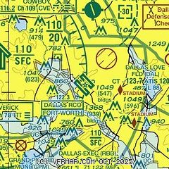
| Sectional chart |
|---|
|
CAUTION: Diagram may not be current
 Download PDF
of official airport diagram from the FAA
| Airport distance calculator |
|---|
|
|
| Sunrise and sunset |
|---|
|
Times for 18-Jul-2026
| | Local
(UTC-5) | | Zulu
(UTC) |
|---|
| Morning civil twilight | | 06:05 | | 11:05 |
| Sunrise | | 06:33 | | 11:33 |
| Sunset | | 20:34 | | 01:34 |
| Evening civil twilight | | 21:02 | | 02:02 |
|
| Current date and time |
|---|
| Zulu (UTC) | 18-Jul-2026 15:25:23 |
|---|
| Local (UTC-5) | 18-Jul-2026 10:25:23 |
|---|
|
| METAR |
|---|
| KDAL | 181453Z 17010G15KT 10SM FEW024 SCT200 BKN250 30/23 A3009 RMK AO2 SLP180 T03000228 50002
|
KADS
7nm N | 181452Z 21006G16KT 10SM FEW021 29/25 A3010
|
KDFW
9nm W | 181453Z 20011KT 10SM FEW020 FEW190 SCT250 29/23 A3007 RMK AO2 SLP174 T02940228 50003 $
|
KRBD
10nm S | 181453Z 19011KT 10SM CLR 29/24 A3009 RMK AO2 SLP179 T02890239 50002
|
KGPM
13nm SW | 181500Z AUTO 20011G16KT 10SM SCT110 29/22 A3011 RMK AO2 T02900219
|
KGKY
17nm SW | 181453Z 17012G17KT 10SM CLR 29/23 A3009 RMK AO2 SLP179 T02890233 50001 $
|
KHQZ
17nm E | 181450Z 19012G18KT 10SM SCT018 28/23 A3010
|
|
| TAF |
|---|
| KDAL | 181120Z 1812/1912 18012KT P6SM SCT025 TEMPO 1813/1815 BKN020 FM181600 18016KT P6SM SCT060 FM190200 18007KT P6SM FEW250
|
KDFW
9nm W | 181120Z 1812/1918 18012KT P6SM SCT025 TEMPO 1813/1815 BKN020 FM181600 18016KT P6SM SCT060 FM190200 18007KT P6SM FEW250
|
KGKY
17nm SW | 181120Z 1812/1912 18012KT P6SM SCT025 TEMPO 1813/1815 BKN020 FM181600 18016KT P6SM SCT060 FM190200 18007KT P6SM FEW250
|
|
| NOTAMs |
|---|
NOTAMs are issued by the DoD/FAA and will open in a separate window not controlled by AirNav.
|
|
FBO, Fuel Providers, and Aircraft Ground Support |
|---|
| | 
Business Name | |
Contact | |
Services / Description | |
Fuel Prices | |
Comments | |
|---|
 |
|
ASRI 130.65
214-654-0994
[web site]
[email] |
|
Atlantic Aviation is your premier aviation service provider with more than 100 locations in North America, including Hawaii and the Caribbean. We provide standard ground services you'd expect, with a detailed focus on ensuring an unforgettable customer experience.


|
|
 | | 100LL | Jet A | | FS | | $8.07 | | $7.32 | | Updated 18-Jul-2026 |
|
|

write
|
|


|
|
ASRI 129.80
214-654-1600
toll-free 888-387-7477
[web site]
[email] |
|
Unrivaled Service. Unforgettable Experiences.


|
|
 | | 100LL | Jet A | | FS | | $7.49 | | $6.56 | | Updated 14-Jul-2026 |
|
|
2 read write
|
|
 |
|
ASRI 131.05
214-350-8523
toll-free 800-966-2378
[web site]
[email] |
|
Full service FBO dedicated to making your travel seamless.


|
|
 | | 100LL | Jet A | SAF | | FS | | $8.57 | | $6.27 | | $7.19 | | GUARANTEED |  | MEMBERS
ONLY
Discounts |
| |
|
|
write
|
|
 |
|
ASRI 130.40
214-956-1000
[web site]
[email] |
|
Signature Aviation at Dallas Love Field Airport (DAL) serves as a premier private aviation terminal for Dallas. Supporting both business and private aviation, our DAL T1 location delivers safe, efficient, and seamless FBO services, with convenient access to downtown, the Dallas Arts District, and the city's cultural and business centers. To request a reservation, log into Signature Vision at https://www.signatureaviation.com/services/signature-vision.

|
|
| | 100LL | Jet A | | FS | | $9.21 | | $7.22 | | Updated 18-Jul-2026 |
|
|
write
|
|
|
|
|
ASRI 130.75
214-353-7000
[web site]
[email] |
|
Signature Aviation at Dallas Love Field Airport (DAL) serves as a premier private aviation terminal for Dallas, delivering safe, efficient, and seamless FBO services. Reserve via Signature Vision: https://www.signatureaviation.com/services/signature-vision.
|
|
| | 100LL | Jet A | | FS | | $9.21 | | $7.22 | | Updated 18-Jul-2026 |
|
|
write
|
|
|
|
|
ASRI 129.275
214-351-1872
[web site]
[email] |
|
Signature Terminal 3 at Dallas-Love Field, located at Alpha 3 (8321 Lemmon Ave.) only offers charter services and no General Aviation or Retail services.
Dallas is the heart of a North Texas economy with over 6 million residents and 3 million jobs. Downtown/Uptown Dallas is the metro area's largest employment center (134,000 jobs). Reaching your business operations, markets and suppliers is easy.
|
|
| | 100LL | Jet A | | FS | | $9.21 | | $7.22 | | Updated 18-Jul-2026 |
|
|
write
|
|

|
|
ASRI 131.60
214-214-7701
[web site]
[email] |
|
Signature Aviation at Dallas Love Field Airport (DAL) at Terminal 4 serves as a premier private aviation terminal for Dallas. Supporting both business and private aviation, our DAL location delivers safe, efficient, and seamless FBO services, with convenient access to downtown, the Dallas Arts District, and key cultural and business destinations. To request a reservation, log into Signature Vision at https://www.signatureaviation.com/services/signature-vision.
|
|
| | 100LL | Jet A | SAF | | FS | | $9.21 | | $7.22 | | $8.97 | | Updated 18-Jul-2026 |
|
|
write
|
|
Alternatives at nearby airports
IMPORTANT: Note that the FBOs below are NOT at KDAL but at other nearby airports. Do not expect services from these FBOs to be available at KDAL. |
 |
|
ASRI 131.90
214-623-8800
[web site]
[email] |
|
At KRBD (Dallas Executive Airport), 10 miles S
Premier FBO situated minutes south of Downtown Dallas in the growing Southern Sector of the Dallas warehouse and distribution district.
No daily ramp or landing fees (overnight ramp and hangar fees do apply.)
Enjoy unmatched personal service and inviting facilities designed to make your stay enjoyable.
Give one of our Customer Service Agents a call today and let us arrange your next Metro Dallas area visit..
|
|
| Located at KRBD |  | | 100LL | Jet A | | FS | | $7.00 | | $6.55 | | GUARANTEED | | MEMBER
PRICING |
| | FS | | $6.90 | | $6.40 |
|
|

17 read write
|
|
 |
|
ASRI 129.025
972-248-1600
toll-free 800-248-1602
[web site]
[email] |
|
At KADS (Addison Airport), 7 miles N
Million Air Dallas pioneered the idea of luxury FBOs. Today, we continue to elevate the experience for pilots and passengers who arrive at our facility. As a preferred FBO, we go beyond industry standards to provide a higher tier of service for our clients with unmatched amenities.
|
|
| Located at KADS | | | 100LL | Jet A | | FS | | $8.25 | | $6.40 | | Updated 10-Jul-2026 |
|
|
1 read write
|
|
 |
|
ASRI 128.975
817-532-5080
[web site]
[email] |
|
At KRBD (Dallas Executive Airport), 10 miles S
We know maximizing your time on the ground is important. Jet Access is conveniently located less than 15 minutes from downtown Dallas. Let our concierge team coordinate everything you need to make the most of your trip to Dallas!
- Fuel Volume Discounts
- After-hours Available
- Courtesy Vehicles
- Rental Cars
- Long-term & Short-Term Hangar
- Office Space Available
- Aircraft Sales
- 135 Charter
- Less than 15 minutes from Downtown Dallas
- Minutes from the Convention Center & Market Center
- Call 817-532-5080 or email RBDinfo@flyja.com for Customized Fuel Pricing & Hangar Quotes
|
|
| Located at KRBD |  | | 100LL | Jet A | | FS | | $7.00 | | $6.05 | | Updated 10-Jul-2026 |
|
|
write
|
|
 |
|
972-216-4132
972-216-4130
[web site]
[email] |
|
At KHQZ (Mesquite Metro Airport), 17 miles ESE
No delays. Competitive prices. Sincere Service. Touch down at Mesquite Executive Air Center and find out why we are the best approach into Dallas.
|
|
|
|
2 read write
|
|

|
| |
Getting Around: Taxi, Limo, Rental Cars, Mass Transit |
|---|
| |
Business Name | |
Contact | |
Services / Description | |
Comments | |
|---|
| DART, Bus Routes 39 and 539 |
|
[web site]
|
|
no information available
If you are affiliated with DART, Bus Routes 39 and 539 and would like to show here your services, contact info, web link, logo, and more, click here
|
|
write
|
|
| |
Things to do: Attractions on or near the airport |
|---|
| |
Business Name | |
Contact | |
Services / Description | |
Distance | |
Comments | |
|---|
| Frontiers of Flight Museum |
|
214-350-3600
|
|
no information available
If you are affiliated with Frontiers of Flight Museum and would like to show here your services, contact info, web link, logo, and more, click here
|
|
on airport |
|
write
|
|
| |
Would you like to see your business listed on this page? |
|---|
| | If your business provides an interesting product or service to pilots, flight crews, aircraft, or users of the Dallas Love Field Airport, you should consider listing it here. To start the listing process, click on the button below

|


