FAA INFORMATION EFFECTIVE 14 MAY 2026
Location
| FAA Identifier: | SPS |
| Lat/Long: | 33-59-19.6800N 098-29-30.8600W
33-59.328000N 098-29.514333W
33.9888000,-98.4919056
(estimated) |
| Elevation: | 1019.1 ft. / 310.6 m (surveyed) |
| Variation: | 05E (2010) |
| From city: | 5 miles N of WICHITA FALLS, TX |
| Time zone: | UTC -5 (UTC -6 during Standard Time) |
| Zip code: | 76311 |
Airport Operations
| Airport use: | Open to the public |
| Control tower: | yes |
| ARTCC: | FORT WORTH CENTER |
| FSS: | FORT WORTH FLIGHT SERVICE STATION
LC CALL TO FSS 855-5574. |
| NOTAMs facility: | SPS (NOTAM-D service available) |
| Attendance: | CONTINUOUS |
| Pattern altitude: | TPA: 800 FT AGL LGT ACFT, 800 FT AGL, 1300 FT AGL CONVENTIONAL & JET, RWY 15R/33L 1800 FT AGL OVERHEAD. |
| Wind indicator: | lighted |
| Segmented circle: | no |
| Lights: | WHEN ATCT CLSD ACTVT MALSR RWY 33L - CTAF. |
| Beacon: | white-green (lighted land airport)
Operates sunset to sunrise. |
| Fire and rescue: | ARFF index B |
Airport Communications
| CTAF: | 119.75 |
| UNICOM: | 122.95 |
| ATIS: | 132.05 269.9 |
| WX ASOS: | PHONE 940-208-0073 |
| SHEPPARD GROUND: | 125.5 289.4 [OPR 1200-0200Z++ MON-FRI; 1800-2300Z++ SUN; CLSD SAT AND HOL, OT USE CTAF.] |
| SHEPPARD TOWER: | 119.75 279.525 [OPR 1200-0200Z++ MON-FRI; 1800-2300Z++ SUN; CLSD SAT AND HOL, OT USE CTAF.] |
| SHEPPARD APPROACH: | 118.2 269.025 [OPR 1200-0200Z++ MON-FRI; 1800-2300Z++ SUN; CLSD SAT AND HOL, OT CTC FORT WORTH CENTER 133.5 350.35.] |
| SHEPPARD DEPARTURE: | 118.2 120.4 269.025 316.075 [OPR 1200-0200Z++ MON-FRI; 1800-2300Z++ SUN; CLSD SAT AND HOL, OT CTC FORT WORTH CENTER 133.5 350.35.] |
| CLEARANCE DELIVERY: | 121.2 282.225 |
| EMERG: | 121.5 243.0 |
| PMSV METRO: | 339.65 |
| PTD: | 372.2 |
| WX AWOS-3 at CWC (8 nm S): | 119.625 (940-766-2967) |
- APCH/DEP SVC PRVDD BY FORT WORTH ARTCC (ZFW) ON FREQS 133.5/350.35 (WICHITA FALLS RCAG) WHEN SHEPPARD APCH CLSD.
- PMSV METRO: WX OPR HR 0500Z++ MON THRU 0100Z++ SAT, 1300-2200Z++ SUN, CLSD SAT AND HOL; OPR HR MAY VARY BY LCL FLYING SKED. CTC C940-676-2730/DSN 736-2730. KSPS ASOS REMAINS OPNL. WINDS ISSUED BY TWR ARE OFFL AFLD WINDS FM THE CNTR RWY.
- MNT 1200 - 0200Z++ MON-FRI, 1800 - 2300Z++ SUN, EXC HOL.
- WINDS ISSUED BY TWR ARE OFFL WINDS FM CTR RWY.
Nearby radio navigation aids
| VOR radial/distance | | VOR name | | Freq | | Var |
|---|
| SPSr079/5.1 | | WICHITA FALLS VORTAC | | 112.70 | | 10E |
| LAWr178/30.7 | | LAWTON VOR/DME | | 116.85 | | 09E |
Airport Services
| Fuel available: | 100LL JET-A |
| Parking: | tiedowns |
| Airframe service: | MINOR |
| Powerplant service: | MINOR |
| Bottled oxygen: | NONE |
Runway Information
Runway 15R/33L
| Dimensions: | 13100 x 300 ft. / 3993 x 91 m |
| Surface: | concrete |
| Weight bearing capacity: | |
| Runway edge lights: | high intensity |
| RUNWAY 15R | | RUNWAY 33L |
| Latitude: | 34-00.226667N | | 33-58.220500N |
| Longitude: | 098-29.970167W | | 098-29.009500W |
| Elevation: | 998.3 ft. | | 1000.2 ft. |
| Traffic pattern: | right | | left |
| Runway heading: | 153 magnetic, 158 true | | 333 magnetic, 338 true |
| Markings: | precision, in good condition | | precision, in good condition |
| Visual slope indicator: | 4-light PAPI on left (3.00 degrees glide path) | | 4-light PAPI on left (3.00 degrees glide path) |
| Approach lights: | MALSR: 1,400 foot medium intensity approach lighting system with runway alignment indicator lights | | MALSR: 1,400 foot medium intensity approach lighting system with runway alignment indicator lights |
| Touchdown point: | yes, no lights | | yes, no lights |
| Instrument approach: | | | ILS/DME |
Runway 15C/33C
| Dimensions: | 10003 x 150 ft. / 3049 x 46 m |
| Surface: | asphalt/concrete/grooved
RWY 15C FIRST 2000 FT, LAST 1000 FT CONC, MID ZONE ASPH. |
| Weight bearing capacity: | |
| Runway edge lights: | high intensity |
| Operational restrictions: | CLOSED. |
| RUNWAY 15C | | RUNWAY 33C |
| Latitude: | 34-00.376008N | | 33-58.844167N |
| Longitude: | 098-29.828623W | | 098-29.095000W |
| Elevation: | 1003.1 ft. | | 989.4 ft. |
| Traffic pattern: | left | | left |
| Runway heading: | 153 magnetic, 158 true | | 333 magnetic, 338 true |
| Markings: | precision, in good condition | | precision, in good condition |
| Visual slope indicator: | 4-light PAPI on left (3.00 degrees glide path) | | 4-light PAPI on left (3.00 degrees glide path) |
| Approach lights: | ALSF1: standard 2,400 foot high intensity approach lighting system with centerline sequenced flashers (category I) | | ALSF1: standard 2,400 foot high intensity approach lighting system with centerline sequenced flashers (category I) |
| Touchdown point: | yes, no lights | | yes, no lights |
| Instrument approach: | LOC/GS | | |
Runway 18/36
| Dimensions: | 7021 x 150 ft. / 2140 x 46 m |
| Surface: | asphalt/grooved |
| Weight bearing capacity: | |
| Runway edge lights: | high intensity |
| RUNWAY 18 | | RUNWAY 36 |
| Latitude: | 33-58.945333N | | 33-57.788000N |
| Longitude: | 098-29.746667W | | 098-29.758500W |
| Elevation: | 1001.0 ft. | | 1014.4 ft. |
| Traffic pattern: | right | | left |
| Runway heading: | 175 magnetic, 180 true | | 355 magnetic, 000 true |
| Markings: | nonprecision, in good condition | | nonprecision, in good condition |
| Runway end identifier lights: | | | yes |
| Touchdown point: | yes, no lights | | yes, no lights |
Runway 15L/33R
| Dimensions: | 6000 x 150 ft. / 1829 x 46 m |
| Surface: | asphalt/concrete/grooved
FIRST & LAST 1000 FT CONC; MID ZONE ASPH. |
| Weight bearing capacity: | |
| Runway edge lights: | high intensity |
| RUNWAY 15L | | RUNWAY 33R |
| Latitude: | 34-00.670500N | | 33-59.751667N |
| Longitude: | 098-29.596667W | | 098-29.156667W |
| Elevation: | 1019.1 ft. | | 999.7 ft. |
| Traffic pattern: | left | | left |
| Runway heading: | 153 magnetic, 158 true | | 333 magnetic, 338 true |
| Markings: | nonprecision, in good condition | | nonprecision, in good condition |
| Visual slope indicator: | 4-light PAPI on left (3.00 degrees glide path) | | 4-light PAPI on left (3.00 degrees glide path) |
| Runway end identifier lights: | yes | | yes |
| Touchdown point: | yes, no lights | | yes, no lights |
Airport Ownership and Management from official FAA records
| Ownership: | U.S. Air Force |
| Owner: | UNITED STATES AIR FORCE.
SHEPPARD AFB
WICHITA FALLS, TX 76311 |
| Manager: | JENNY STEVENS
4000 ARMSTRONG DR, STE 8
WICHITA FALLS, TX 76305
Phone 940-761-4306
FBO 940-855-5460. |
Additional Remarks
| E60-15C | BAK 15 (175 FT OVRN). |
| E60-33C | BAK 15 (175 FT OVRN). |
| E60-15R | MA-1A CHAG (145 FT OVRN). |
| E60-33L | MA-1A CHAG (145 FT OVRN). |
| - | CAUTION: "MIL ARPT CONDUCTS HI PERFORMANCE JET TRNG IN A HI DENSITY ENVIRONMENT WITHIN 95 NM OF KSPS, 1200-0200Z++ MON-FRI TO FL390, AND WHEN TWR HR EXTN BY NOTAM, OCCASIONALLY SAT AND SUN. |
| - | A-GEAR: MA-1A RWY 15R-33L NOT RAISED, UNLESS 80TH FTW IS FLYING, RQR 30 MIN PN WHEN TWR OPR. |
| - | MISC: BASE OPS 1200-0200Z++ WKD; 1800-2300Z++ SUN; CLSD SAT AND HOL. |
| - | DUE TO CLOSE PROXIMITY OF RYS 33L & 33C USE VIGILANCE WITH MONITOR GND TRACK FOR THE HI-TACAN RY 33C APCH. |
| - | RSTD: SOLO STU N/A. |
| - | MISC: WX OBSERVATION LTD TO WEST DUE TO RSTD VIEW. |
| - | TRAN ALERT: OPR 1200-0200Z++ WKD; 1800-2300Z++ SUN, CLSD SAT AND HOL. |
| - | SERVICE-LGT: RWY 15R-33L PAPI RRP AND ILS RPI NOT COINCIDENTAL. |
| - | SERVICE-LGT: RWY 15C-33C PAPI GS AND ILS GS NOT COINCIDENTAL. |
| - | RSTD: ALL TRAN ACFT MUST BE CHOCKED 30 MIN PRIOR TO TRANS ALERT CLOSING; PPR EXPIRES 30 MIN PRIOR TO AFLD CLOSING.ALL TRAN ACFT RQRD TO ARR WITH CREW ORDERS FOR SECURITY FORCES |
| - | CAUTION: DO NOT CONFUSE PARL TWY WITH RWY 15R-33L. |
| - | MISC: AETC FTR ACFT EXP REDUCED RY SEPARATION: DAY/VFR, SIMILAR TYPE ACFT 3000 FT, DISSIMILAR TYPE ACFT 6000 FT, NIGHT 6000 FT ALL AETC ACFT. TRAN AETC ACFT NOTIFY TWR ON INITIAL CTC IF REDUCED RY SEPARATION IS NOT DESIRED. |
| - | MISC: MIL WX ADVSY/WARNING AVBL O/R-METRO. |
| - | SERVICE - TRAN ALERT: OPR 1130 -0300Z++ WKD; 1800-2300++ SUN; CLSD SAT AND HOL. QUALIFIED WEAPONS/MUNITIONS PERS NOT AVBL TO SAFE FTR TYPE ACFT. |
| - | JASU: 3(AM32-95) 1(MC-1) 3(AM/32A-86D). |
| - | FLUID: SP PRESAIR LOX. |
| - | SERVICE-OIL JOAP RESULTS AVBL 1345-2100Z++ WKD EXC HOL. |
| - | MISC: CLASS D AIRSPACE EFF 1130-0300Z++ MON-FRI; 1800-2300Z++ SUN; EXC HOL; OT CLASS E. |
| - | CAUTION: ATC PERS IAW THE COOPERATIVE WX WATCH (CWW) WILL ALERT WX PERS ON ANY UNREPORTED WX COND THAT COULD AFFECT FLT SAFETY. |
| - | CAUTION: MIL ARPT CONDUCTS HI PER JET TRNG IN A HI DENSITY ENVIRONMENT 1400-0400Z++ MON-FRI AND WHEN TWR HR EXTN BY NOTAM; OCNLY SAT. TRANS MIL ACFT NOT AUZD TO ARR/DEP OUTSIDE OF PUBL HR. |
| - | MISC: EXPECT NO AF SVC WHILE PRK AT THE RGN ARPT. |
| - | RSTD: PPR, 24 HR PN RQR, CTC AFLD OPS DSN 736-2180/6474, C940-676-2180/6474. |
| - | MISC: CTC BASE TAXI DSN 736-1843 C940-676-1843, OR U-DRIVE DSN 736-6813 C940-676-6813 PRIOR TO ARR. |
| - | SERVICE-FUEL: A++. |
| - | AFLD OPS FLT/COMMAND POST AT C940-676-2616. |
| - | FOR CD IF UNA TO CTC ON FSS FREQ, CTC FORT WORTH ARTCC AT 817-858-7584. |
| - | SERVICE-LGT: RWY 15C SFL OTS UFN. |
| - | RSTD: RWY 15L/33R FOR 80 FTW T-6 ACFT USE ONLY. |
| - | SERVICE-LGT: RWY 33C SFL OTS UFN. |
| - | RSTD: RWY 15C/33C CLSD EXC XNG AT TWY G FOR 80 FTW ACFT. TWY K AND TWY G EAST OF RWY 15R/33L CLSD EXC FOR 80 FTW ACFT. TWY L AND TWY F BTWN RWY 15R/33L AND APCH END RWY 33C CLSD. |
| - | MISC: FOR INFO ABT THE WICHITA FALLS MUNI ARR PROCS VISIT: WWW.SHEPPARD.AF.MIL/CONTACT/SHARE-THE-AIR. |
| - | ILS/RADAR: ILS OR LOC/DME - ILS 15C NOT AVBL. |
| - | DURING PERIODS WHEN CTL TWR IS CLSD EXERCISE CAUTION WHEN TAXIING; THE CIVIL ARPT IS LCTD TO THE S AND THE MIL RAMP IS LCTD TO THE W OF THE RWYS. FLD COND NOTAM (FICON) (RSC/RCR) NOT RPRTD WHEN TWR CLSD. |
| - | RSTD: TRAN ACFT LTD TO ONE APCH TO A FULL STOP LDG AND MUST TAXI TO PRKG DURG STU TRNG. |
| - | MIGRATORY BIRD ACTIVITY ON & INVOF ARPT FM OCT-APR. |
Instrument Procedures
NOTE: All procedures below are presented as PDF files. If you need a reader for these files, you should download the free Adobe Reader.NOT FOR NAVIGATION. Please procure official charts for flight.
FAA instrument procedures published for use from 14 May 2026 at 0901Z to 11 June 2026 at 0900z.
IAPs - Instrument Approach Procedures |
|---|
| HI-ILS OR LOC Z RWY 33L | |
download (160KB) |
| ILS OR LOC Y RWY 33L | |
download (136KB) |
| RNAV (GPS) RWY 15L | |
download (121KB) |
| RNAV (GPS) RWY 15R | |
download (148KB) |
| RNAV (GPS) RWY 33L | |
download (143KB) |
| VOR/DME-E | |
download (125KB) |
| HI-TACAN RWY 15R | |
download (159KB) |
| HI-TACAN RWY 33L | |
download (156KB) |
| Radar Approach Procedures available | |
download (157KB) |
| NOTE: Special Take-Off Minimums/Departure Procedures apply | |
download (297KB) |
Other nearby airports with instrument procedures:
F14 - Wichita Valley Airport (7 nm W)
KCWC - Kickapoo Downtown Airport (8 nm S)
KFDR - Frederick Regional Airport (33 nm NW)
KLAW - Lawton-Fort Sill Regional Airport (35 nm N)
KDUC - Halliburton Field Airport (39 nm NE)
|
|

Road maps at:
MapQuest
Bing
Google
| Aerial photo |
|---|
WARNING: Photo may not be current or correct

Do you have a better or more recent aerial photo of Sheppard Air Force Base/Wichita Falls Municipal Airport that you would like to share? If so, please send us your photo.
|
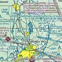
| Sectional chart |
|---|
|
 Download PDF
of official airport diagram from the FAA
| Airport distance calculator |
|---|
|
|
| Sunrise and sunset |
|---|
|
Times for 14-May-2026
| | Local
(UTC-5) | | Zulu
(UTC) |
|---|
| Morning civil twilight | | 06:07 | | 11:07 |
| Sunrise | | 06:34 | | 11:34 |
| Sunset | | 20:26 | | 01:26 |
| Evening civil twilight | | 20:54 | | 01:54 |
|
| Current date and time |
|---|
| Zulu (UTC) | 14-May-2026 17:10:58 |
|---|
| Local (UTC-5) | 14-May-2026 12:10:58 |
|---|
|
| METAR |
|---|
| KSPS | 141652Z 00000KT 10SM CLR 30/16 A2994 RMK AO2 SLP124 T03000161
|
KCWC
8nm S | 141655Z AUTO 21010G14KT 10SM CLR 32/16 A2997 RMK AO2 T03150159
|
|
| TAF |
|---|
| KSPS | 141120Z 1412/1512 14008KT P6SM SCT250 FM141500 19014G22KT P6SM SCT250 FM141800 17021G29KT P6SM SCT250 FM150200 17015G23KT P6SM SCT150 BKN250
|
|
| NOTAMs |
|---|
NOTAMs are issued by the DoD/FAA and will open in a separate window not controlled by AirNav.
|
|


