FAA INFORMATION EFFECTIVE 16 APRIL 2026
Location
| FAA Identifier: | LAW |
| Lat/Long: | 34-34-03.7720N 098-24-59.8920W
34-34.062867N 098-24.998200W
34.5677144,-98.4166367
(estimated) |
| Elevation: | 1110.3 ft. / 338.4 m (surveyed) |
| Variation: | 06E (2000) |
| From city: | 2 miles S of LAWTON, OK |
| Time zone: | UTC -5 (UTC -6 during Standard Time) |
| Zip code: | 73501 |
Airport Operations
| Airport use: | Open to the public |
| Activation date: | 12/1948 |
| Control tower: | yes |
| ARTCC: | FORT WORTH CENTER |
| FSS: | MC ALESTER FLIGHT SERVICE STATION |
| NOTAMs facility: | LAW (NOTAM-D service available) |
| Attendance: | MON-FRI 0530-2000, ALL SAT-SUN 0530-1900 |
| Wind indicator: | lighted |
| Segmented circle: | yes |
| Lights: | ATCT CTLS ALL RWY & TWY LGTG WHEN OPEN; WHEN ATCT CLSD, MALSR RWY 35; REIL RWY 17; HIRL RWY 17/35; TWY LGTG ON MED INTST. INCR/DECR INTST - CTAF. PAPI RWY 17 ON CONSLY, VRBL INTST - CTAF. |
| Beacon: | white-green (lighted land airport)
Operates sunset to sunrise. |
| Fire and rescue: | ARFF index B |
| Airline operations: | PPR FOR UNSKED PART 121 ACR OPS WITH MORE THAN 30 PAX SEATS - AMGR. |
Airport Communications
| CTAF: | 119.9 |
| UNICOM: | 122.95 |
| ATIS: | 120.75 |
| WX ASOS: | 120.75 (580-581-1351) |
| LAWTON GROUND: | 121.9 [0800-1900] |
| LAWTON TOWER: | 119.9 257.8 [0800-1900] |
| FORT SILL APPROACH: | 120.55 |
| FORT SILL DEPARTURE: | 120.55 |
| EMERG: | 121.5 243.0 |
Nearby radio navigation aids
| VOR radial/distance | | VOR name | | Freq | | Var |
|---|
| LAWr349/4.3 | | LAWTON VOR/DME | | 116.85 | | 09E |
| SPSr004/35.9 | | WICHITA FALLS VORTAC | | 112.70 | | 10E |
| HBRr109/36.6 | | HOBART VORTAC | | 115.85 | | 10E |
Airport Services
| Fuel available: | 100LL JET-A1+ |
| Parking: | hangars and tiedowns |
| Airframe service: | MAJOR |
| Powerplant service: | MAJOR |
| Bottled oxygen: | NONE |
| Bulk oxygen: | HIGH/LOW |
Runway Information
Runway 17/35
| Dimensions: | 8599 x 150 ft. / 2621 x 46 m |
| Surface: | concrete/wired/combed, in good condition |
| Weight bearing capacity: | | Single wheel: | 45.0 | | Double wheel: | 179.0 | | Double tandem: | 344.0 |
|
| Runway edge lights: | high intensity |
| RUNWAY 17 | | RUNWAY 35 |
| Latitude: | 34-34.713133N | | 34-33.297633N |
| Longitude: | 098-25.029150W | | 098-24.937083W |
| Elevation: | 1110.3 ft. | | 1070.1 ft. |
| Traffic pattern: | left | | left |
| Runway heading: | 171 magnetic, 177 true | | 351 magnetic, 357 true |
| Declared distances: | TORA:8599 TODA:8599 ASDA:8599 LDA:8599 | | TORA:8599 TODA:8599 ASDA:8599 LDA:8599 |
| Markings: | precision, in fair condition | | precision, in fair condition |
| Visual slope indicator: | 4-light PAPI on right (3.00 degrees glide path) | | |
| Approach lights: | | | MALSR: 1,400 foot medium intensity approach lighting system with runway alignment indicator lights |
| Runway end identifier lights: | yes | | |
| Touchdown point: | yes, no lights | | yes, no lights |
| Instrument approach: | | | ILS |
| Obstructions: | 72 ft. pole, lighted, 3100 ft. from runway, 170 ft. right of centerline, 40:1 slope to clear | | none |
Airport Ownership and Management from official FAA records
| Ownership: | Publicly-owned |
| Owner: | CITY OF LAWTON
BOX 531
LAWTON, OK 73502
Phone 580-581-3301 |
| Manager: | BARBARA MCNALLY
3401 S 11TH ST
LAWTON, OK 73501
Phone 580-353-4869
EXTENSION 301. |
Additional Remarks
| A39-17/35 | PCR VALUE: 610/R/B/W/T |
| - | WHEN ATCT CLSD ARFF AVBL THROUGH FORT SILL APCH. |
| - | BIRDS ON & INVOF ARPT. |
| - | WHEN ATCT CLSD, FOR CD CTC FORT WORTH ARTCC AT 817-858-7584. |
Instrument Procedures
NOTE: All procedures below are presented as PDF files. If you need a reader for these files, you should download the free Adobe Reader.NOT FOR NAVIGATION. Please procure official charts for flight.
FAA instrument procedures published for use from 16 April 2026 at 0901Z to 14 May 2026 at 0900Z.
IAPs - Instrument Approach Procedures |
|---|
| ILS OR LOC RWY 35 | |
download (240KB) |
| RNAV (GPS) RWY 35 | |
download (227KB) |
| VOR RWY 35 | |
download (215KB) |
| Radar Approach Procedures available | |
download (31KB) |
| NOTE: Special Alternate Minimums apply | |
download (56KB) |
| NOTE: Special Take-Off Minimums/Departure Procedures apply | |
download (131KB) |
Other nearby airports with instrument procedures:
KFSI - Henry Post Army Airfield (Fort Sill) (5 nm N)
KDUC - Halliburton Field Airport (23 nm E)
KFDR - Frederick Regional Airport (31 nm SW)
KSPS - Sheppard Air Force Base/Wichita Falls Municipal Airport (35 nm S)
F14 - Wichita Valley Airport (38 nm S)
|
|

Road maps at:
MapQuest
Bing
Google
| Aerial photo |
|---|
WARNING: Photo may not be current or correct

Do you have a better or more recent aerial photo of Lawton-Fort Sill Regional Airport that you would like to share? If so, please send us your photo.
|
| Sectional chart |
|---|
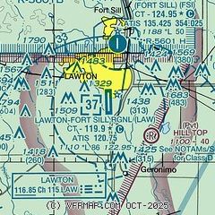
|
CAUTION: Diagram may not be current
 Download PDF
of official airport diagram from the FAA
| Airport distance calculator |
|---|
|
|
| Sunrise and sunset |
|---|
|
Times for 21-Apr-2026
| | Local
(UTC-5) | | Zulu
(UTC) |
|---|
| Morning civil twilight | | 06:29 | | 11:29 |
| Sunrise | | 06:56 | | 11:56 |
| Sunset | | 20:09 | | 01:09 |
| Evening civil twilight | | 20:35 | | 01:35 |
|
| Current date and time |
|---|
| Zulu (UTC) | 22-Apr-2026 04:55:06 |
|---|
| Local (UTC-5) | 21-Apr-2026 23:55:06 |
|---|
|
| METAR |
|---|
| KLAW | 220353Z AUTO 14009KT 3SM BR OVC003 15/15 A3009 RMK AO2 SLP185 T01500150
|
KFSI
4nm N | 220425Z AUTO 16005KT 7SM OVC003 16/15 A3004 RMK AO2 SLP167 $
|
|
| TAF |
|---|
| KLAW | 220341Z 2204/2224 15011KT 2SM BR OVC003 TEMPO 2209/2213 1SM BR OVC001 FM221500 16011KT P6SM OVC007 FM221800 16014KT P6SM BKN015
|
|
| NOTAMs |
|---|
NOTAMs are issued by the DoD/FAA and will open in a separate window not controlled by AirNav.
|
|


