FAA INFORMATION EFFECTIVE 22 JANUARY 2026
Location
| FAA Identifier: | 17G |
| Lat/Long: | 40-46-53.7000N 082-58-29.3000W
40-46.895000N 082-58.488333W
40.7815833,-82.9748056
(estimated) |
| Elevation: | 1007.8 ft. / 307.2 m (surveyed) |
| Variation: | 07W (2010) |
| From city: | 1 mile S of BUCYRUS, OH |
| Time zone: | UTC -5 (UTC -4 during Daylight Saving Time) |
| Zip code: | 44820 |
Airport Operations
| Airport use: | Open to the public |
| Activation date: | 12/1937 |
| Control tower: | no |
| ARTCC: | CLEVELAND CENTER |
| FSS: | CLEVELAND FLIGHT SERVICE STATION |
| NOTAMs facility: | CLE (NOTAM-D service available) |
| Attendance: | 0800-1700
UNATNDD MAJOR HOLS. |
| Wind indicator: | lighted |
| Segmented circle: | no |
| Lights: | ACTVT WINDSOCK; WIND T; REIL RWY 04 & 22; MIRL RWY 04/22 - CTAF. PAPI RWY 04 & 22 OPR CONSLY. |
| Beacon: | white-green (lighted land airport)
Operates sunset to sunrise. |
Airport Communications
| CTAF/UNICOM: | 122.8 |
| WX AWOS-3: | 126.625 (419-562-0279) |
| CLEVELAND APPROACH: | 128.35 |
| CLEVELAND DEPARTURE: | 128.35 |
| WX ASOS at MNN (11 nm S): | 119.975 (740-223-7502) |
| WX AWOS-3PT at 4I9 (16 nm S): | 121.4 (419-947-1039) |
- APCH/DEP SVC PRVDD BY CLEVELAND APCH (CLE) 0600-0100. APCH/DEP SVC PRVDD BY CLEVELAND ARTCC (ZOB) ON FREQS 135.1/291.725 (FINDLAY RCAG) 0100-0600.
Nearby radio navigation aids
| VOR radial/distance | | VOR name | | Freq | | Var |
|---|
| BUDr027/(10.7) | | BUCKEYE VOR | | 109.80 | | 05W |
| FBCr108/36.9 | | FLAG CITY VORTAC | | 108.20 | | 02W |
| NDB name | | Hdg/Dist | | Freq | | Var | | ID |
|---|
| TIFFIN | | 155/21.7 | | 269 | | 05W | | TII | - .. .. |
Airport Services
| Fuel available: | 100LL JET-A+ |
| Parking: | hangars and tiedowns |
| Airframe service: | MAJOR |
| Powerplant service: | MAJOR |
| Bottled oxygen: | NONE |
| Bulk oxygen: | NONE |
Runway Information
Runway 4/22
| Dimensions: | 3895 x 75 ft. / 1187 x 23 m |
| Surface: | asphalt, in excellent condition |
| Weight bearing capacity: | | Single wheel: | 17.1 | | Double wheel: | 35.0 |
|
| Runway edge lights: | medium intensity |
| RUNWAY 4 | | RUNWAY 22 |
| Latitude: | 40-46.625063N | | 40-47.145580N |
| Longitude: | 082-58.728797W | | 082-58.235890W |
| Elevation: | 1000.1 ft. | | 999.4 ft. |
| Traffic pattern: | left | | left |
| Runway heading: | 043 magnetic, 036 true | | 223 magnetic, 216 true |
| Displaced threshold: | 276 ft. | | no |
| Markings: | nonprecision, in fair condition | | nonprecision, in fair condition |
| Visual slope indicator: | 2-light PAPI on left (3.50 degrees glide path) | | 4-light PAPI on left (3.00 degrees glide path) |
| Runway end identifier lights: | yes | | yes |
| Touchdown point: | yes, no lights | | yes, no lights |
| Obstructions: | 5 ft. crops, 201 ft. from runway, 230 ft. left of centerline
+5 FT CROPS, 200 FT DIST FM DTHR, 230 FT L, 0:1. | | 15 ft. road, 375 ft. from runway, 270 ft. left of centerline, 11:1 slope to clear
OBSTN CLNC SLP 11:1 OVR +15 FT ROAD, 375 FT DIST, 270 FT L. |
Runway 9/27
| Dimensions: | 2902 x 90 ft. / 885 x 27 m |
| Surface: | turf, in good condition |
| RUNWAY 9 | | RUNWAY 27 |
| Latitude: | 40-46.890643N | | 40-46.922022N |
| Longitude: | 082-58.808248W | | 082-58.180832W |
| Elevation: | 996.1 ft. | | 1007.8 ft. |
| Traffic pattern: | left | | left |
| Runway heading: | 093 magnetic, 086 true | | 273 magnetic, 266 true |
| Markings: | none | | none |
| Runway end identifier lights: | no | | no |
| Touchdown point: | yes, no lights | | yes, no lights |
| Obstructions: | 60 ft. tree, 325 ft. from runway, 20 ft. right of centerline, 5:1 slope to clear
OBSTN CLNC SLP 5:1 OVR +60 FT TREE, 325 FT DIST, 20 FT R. | | 55 ft. tree, 275 ft. from runway, 70 ft. left of centerline, 5:1 slope to clear
OBSTN CLNC SLP 5:1 OVR +55 FT TREE, 275 FT DIST, 70 FT L. |
Airport Ownership and Management from official FAA records
| Ownership: | Publicly-owned |
| Owner: | CITY OF BUCYRUS
PO BOX 1244
BUCYRUS, OH 44820-4244
Phone 419-562-6767 |
| Manager: | KEVIN DETRAY
2254 ISAAC BEAL RD
BUCYRUS, OH 44820-9692
Phone 419-562-7596
KNDETRAY@GMAIL.COM. |
Additional Remarks
| - | FOR CD CTC CLEVELAND APCH AT 216-352-2323, WHEN APCH CLSD CTC CLEVELAND ARTCC AT 440-774-0222/0490. |
| - | RWY 09: -7 FT DITCH ACRS RWY END. |
Instrument Procedures
NOTE: All procedures below are presented as PDF files. If you need a reader for these files, you should download the free Adobe Reader.NOT FOR NAVIGATION. Please procure official charts for flight.
FAA instrument procedures published for use from 22 January 2026 at 0901Z to 19 February 2026 at 0900z.
IAPs - Instrument Approach Procedures |
|---|
| RNAV (GPS) RWY 04 **CHANGED** | |
download (203KB) |
| RNAV (GPS) RWY 22 **CHANGED** | |
download (207KB) |
| NOTE: Special Take-Off Minimums/Departure Procedures apply | |
download (480KB) |
Other nearby airports with instrument procedures:
KMNN - Marion Municipal Airport (11 nm S)
KGQQ - Galion Municipal Airport (12 nm E)
12G - Shelby Community Airport (14 nm NE)
4I9 - Morrow County Airport (16 nm S)
56D - Wyandot County Airport (17 nm W)
8G1 - Willard Airport (19 nm NE)
|
|

Road maps at:
MapQuest
Bing
Google
| Aerial photo |
|---|
WARNING: Photo may not be current or correct
 Taken early October 2019
looking southwest.
Taken early October 2019
looking southwest.
Do you have a better or more recent aerial photo of Port Bucyrus/Crawford County Airport that you would like to share? If so, please send us your photo.
|
| Sectional chart |
|---|
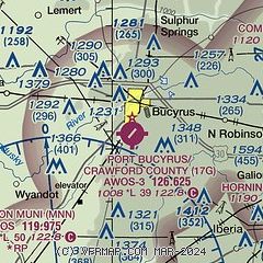
|
| Airport distance calculator |
|---|
|
|
| Sunrise and sunset |
|---|
|
Times for 22-Jan-2026
| | Local
(UTC-5) | | Zulu
(UTC) |
|---|
| Morning civil twilight | | 07:22 | | 12:22 |
| Sunrise | | 07:51 | | 12:51 |
| Sunset | | 17:36 | | 22:36 |
| Evening civil twilight | | 18:06 | | 23:06 |
|
| Current date and time |
|---|
| Zulu (UTC) | 22-Jan-2026 13:13:50 |
|---|
| Local (UTC-5) | 22-Jan-2026 08:13:50 |
|---|
|
| METAR |
|---|
KMNN
11nm SW | 221253Z AUTO 26013G21KT 10SM CLR M06/M11 A3011 RMK AO2 PK WND 26027/1209 SLP210 T10561111
|
KMFD
21nm E | 221252Z 24011G25KT 10SM CLR M06/M09 A3006 RMK AO2 PK WND 23029/1209 SLP194 T10561094
|
|
| TAF |
|---|
KMFD
21nm E | 221122Z 2212/2312 26015G25KT P6SM SCT040 TEMPO 2212/2213 BKN025 FM221700 27014G22KT P6SM SCT025 BKN100 FM222200 26011KT P6SM SCT250
|
|
| NOTAMs |
|---|
NOTAMs are issued by the DoD/FAA and will open in a separate window not controlled by AirNav.
|
|


