FAA INFORMATION EFFECTIVE 09 JULY 2026
Location
| FAA Identifier: | 8G1 |
| Lat/Long: | 41-02-19.5016N 082-43-28.4333W
41-02.325027N 082-43.473888W
41.0387504,-82.7245648
(estimated) |
| Elevation: | 966.6 ft. / 294.6 m (surveyed) |
| Variation: | 06W (1985) |
| From city: | 1 mile S of WILLARD, OH |
| Time zone: | UTC -4 (UTC -5 during Standard Time) |
| Zip code: | 44890 |
Airport Operations
| Airport use: | Open to the public |
| Activation date: | 07/1944 |
| Control tower: | no |
| ARTCC: | CLEVELAND CENTER |
| FSS: | CLEVELAND FLIGHT SERVICE STATION |
| NOTAMs facility: | CLE (NOTAM-D service available) |
| Attendance: | UNATNDD |
| Wind indicator: | yes |
| Segmented circle: | no |
| Lights: | ACTVT MIRL RWY 10/28 - CTAF. |
Airport Communications
| CTAF: | 122.9 |
| CLEVELAND APPROACH: | 128.35 |
| CLEVELAND DEPARTURE: | 128.35 |
| WX ASOS at MFD (16 nm SE): | 125.3 (419-520-7277) |
| WX AWOS-3 at 17G (19 nm SW): | 126.625 (419-562-0279) |
- APCH/DEP SVC PRVDD BY CLEVELAND APCH (CLE) 0600-0100. APCH/DEP SVC PRVDD BY CLEVELAND ARTCC (ZOB) ON FREQS 135.1/291.725 (FINDLAY RCAG) 0100-0600.
- COMMUNICATIONS PRVDD BY CLEVELAND RADIO ON FREQ 122.6 (MANSFIELD RCO).
Nearby radio navigation aids
| VOR radial/distance | | VOR name | | Freq | | Var |
|---|
| BUDr036/(29.6) | | BUCKEYE VOR | | 109.80 | | 05W |
| DJBr238/31.8 | | DRYER VOR/DME | | 113.60 | | 05W |
| NDB name | | Hdg/Dist | | Freq | | Var | | ID |
|---|
| TIFFIN | | 104/22.4 | | 269 | | 05W | | TII | - .. .. |
Airport Services
| Fuel available: | 100LL
100LL:FOR FUEL WKDAYS 0700-1500 CALL AMGR; AFT HRS CALL 419-933-2561. |
| Parking: | tiedowns |
Runway Information
Runway 10/28
| Dimensions: | 4028 x 65 ft. / 1228 x 20 m |
| Surface: | asphalt, in fair condition |
| Runway edge lights: | medium intensity |
| RUNWAY 10 | | RUNWAY 28 |
| Latitude: | 41-02.368032N | | 41-02.281995N |
| Longitude: | 082-43.908197W | | 082-43.039590W |
| Elevation: | 966.6 ft. | | 936.0 ft. |
| Traffic pattern: | left | | left |
| Runway heading: | 103 magnetic, 097 true | | 283 magnetic, 277 true |
| Displaced threshold: | 300 ft. | | 610 ft. |
| Markings: | basic, in good condition | | basic, in good condition |
| Touchdown point: | yes, no lights | | yes, no lights |
| Obstructions: | 12 ft. bldg, 211 ft. from runway, 87 ft. left of centerline
15 FT ROAD, 75 FT DIST, 125 FT L/R; 15 FT PRKG LOT, 0-90 FT DIST, 50 FT L; 14 FT BLDG, 180 FT DIST, 100 FT L. | | 100 ft. trees, 1224 ft. from runway, 136 ft. left of centerline, 10:1 slope to clear
10 FT PRKG LOT, 135-200 FT DIST, 99-105 FT R. |
Airport Ownership and Management from official FAA records
| Ownership: | Publicly-owned |
| Owner: | CITY OF WILLARD
631 S MYRTLE AVE
WILLARD, OH 44890-1549
Phone 419-933-2591 |
| Manager: | ROB CAVELLO
631 S MYRTLE AVE
WILLARD, OH 44890-1549
Phone 419-933-7531
ARPT PHYS ADS: 3744 STATE ROUTE 103 S, WILLARD, OH 44890. |
Additional Remarks
| - | FOR CD CTC CLEVELAND APCH AT 216-352-2323, WHEN APCH CLSD CTC CLEVELAND ARTCC AT 440-774-0222/0490. |
| - | RWY 28: AUTO DEALER PRKG LOT LGTS SHINE IN RWY APCH. |
| - | DEER, BIRDS, & OTR WILDLIFE ON & INVOF ARPT. |
| - | HOSPITAL HELI 0.4 NM EAST OF RWY END 28. |
Instrument Procedures
NOTE: All procedures below are presented as PDF files. If you need a reader for these files, you should download the free Adobe Reader.NOT FOR NAVIGATION. Please procure official charts for flight.
FAA instrument procedures published for use from 09 July 2026 at 0901Z to 06 August 2026 at 0900Z.
IAPs - Instrument Approach Procedures |
|---|
| RNAV (GPS)-A | |
download (138KB) |
| NOTE: Special Take-Off Minimums/Departure Procedures apply | |
download (331KB) |
Other nearby airports with instrument procedures:
12G - Shelby Community Airport (10 nm S)
5A1 - Norwalk/Huron County Airport (15 nm NE)
KMFD - Mansfield Lahm Regional Airport (16 nm SE)
KGQQ - Galion Municipal Airport (17 nm S)
17G - Port Bucyrus/Crawford County Airport (19 nm SW)
|
|

Road maps at:
MapQuest
Bing
Google
| Aerial photo |
|---|
WARNING: Photo may not be current or correct
 looking east
Do you have a better or more recent aerial photo of Willard Airport that you would like to share? If so, please send us your photo.
|
| Sectional chart |
|---|
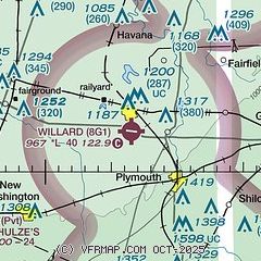
|
| Airport distance calculator |
|---|
|
|
| Sunrise and sunset |
|---|
|
Times for 27-Jul-2026
| | Local
(UTC-4) | | Zulu
(UTC) |
|---|
| Morning civil twilight | | 05:52 | | 09:52 |
| Sunrise | | 06:23 | | 10:23 |
| Sunset | | 20:52 | | 00:52 |
| Evening civil twilight | | 21:23 | | 01:23 |
|
| Current date and time |
|---|
| Zulu (UTC) | 27-Jul-2026 18:41:28 |
|---|
| Local (UTC-4) | 27-Jul-2026 14:41:28 |
|---|
|
| METAR |
|---|
KMFD
16nm SE | 271752Z 24006KT 10SM FEW027 28/20 A2986 RMK AO2 PRESFR SLP101 T02830200 10283 20206 58026 $
|
KPCW
29nm N | 271815Z AUTO 21011G16KT 10SM CLR 29/22 A2974 RMK AO2
|
KMNN
30nm SW | 271753Z AUTO 21009KT 9SM CLR 28/20 A2984 RMK AO2 SLP098 T02830200 10294 20183 58030
|
KLPR
31nm NE | 271753Z AUTO 23010KT 10SM FEW032 29/22 A2982 RMK AO2 SLP090 T02890217 10294 20217 58030
|
|
| TAF |
|---|
KMFD
16nm SE | 271722Z 2718/2818 25008KT P6SM BKN200 FM272300 22009KT P6SM -SHRA BKN080 PROB30 2723/2803 30020G35KT 2SM TSRA BKN035CB FM280800 22010G18KT P6SM BKN035 FM281100 25012G20KT P6SM BKN015 FM281600 31012G20KT P6SM SCT025
|
|
| NOTAMs |
|---|
NOTAMs are issued by the DoD/FAA and will open in a separate window not controlled by AirNav.
|
|


