FAA INFORMATION EFFECTIVE 22 JANUARY 2026
Location
| FAA Identifier: | 5A1 |
| Lat/Long: | 41-14-41.1000N 082-33-04.4000W
41-14.685000N 082-33.073333W
41.2447500,-82.5512222
(estimated) |
| Elevation: | 852.5 ft. / 259.8 m (surveyed) |
| Variation: | 06W (1995) |
| From city: | 3 miles E of NORWALK, OH |
| Time zone: | UTC -5 (UTC -4 during Daylight Saving Time) |
| Zip code: | 44857 |
Airport Operations
| Airport use: | Open to the public |
| Control tower: | no |
| ARTCC: | CLEVELAND CENTER |
| FSS: | CLEVELAND FLIGHT SERVICE STATION |
| NOTAMs facility: | CLE (NOTAM-D service available) |
| Attendance: | UNATNDD |
| Wind indicator: | lighted |
| Segmented circle: | no |
| Lights: | ACTVT MIRL RWY 10/28 - CTAF. |
| Beacon: | white-green (lighted land airport)
Operates sunset to sunrise. |
Airport Communications
| CTAF/UNICOM: | 122.8 |
| CLEVELAND APPROACH: | 128.35 |
| CLEVELAND DEPARTURE: | 128.35 |
| WX ASOS at LPR (18 nm E): | 118.925 (440-323-7088) |
- APCH/DEP SVC PRVDD BY CLEVELAND APCH (CLE) 0600-0100. APCH/DEP SVC PRVDD BY CLEVELAND ARTCC (ZOB) ON FREQS 135.1/291.725 (FINDLAY RCAG) 0100-0600.
Nearby radio navigation aids
| VOR radial/distance | | VOR name | | Freq | | Var |
|---|
| DJBr254/18.8 | | DRYER VOR/DME | | 113.60 | | 05W |
| NDB name | | Hdg/Dist | | Freq | | Var | | ID |
|---|
| TIFFIN | | 078/31.3 | | 269 | | 05W | | TII | - .. .. |
Airport Services
| Fuel available: | 100LL JET-A |
| Parking: | hangars and tiedowns |
| Airframe service: | NONE |
| Powerplant service: | MINOR |
| Bottled oxygen: | NONE |
| Bulk oxygen: | NONE |
Runway Information
Runway 10/28
| Dimensions: | 4208 x 75 ft. / 1283 x 23 m |
| Surface: | asphalt, in fair condition |
| Runway edge lights: | medium intensity |
| RUNWAY 10 | | RUNWAY 28 |
| Latitude: | 41-14.686963N | | 41-14.684627N |
| Longitude: | 082-33.532403W | | 082-32.614315W |
| Elevation: | 834.5 ft. | | 852.1 ft. |
| Traffic pattern: | left | | left |
| Runway heading: | 096 magnetic, 090 true | | 276 magnetic, 270 true |
| Displaced threshold: | 239 ft. | | 667 ft. |
| Markings: | basic, in good condition | | nonprecision, in good condition |
| Runway end identifier lights: | no | | no |
| Touchdown point: | yes, no lights | | yes, no lights |
| Obstructions: | 31 ft. trees, 346 ft. from runway, 126 ft. left of centerline, 4:1 slope to clear
APCH SLP 18:1 TO DTHR OVR 31 FT TREES, 585 FT DIST, 126 FT R. | | 17 ft. road, 201 ft. from runway, 240 ft. left of centerline
17 FT DRAG STRIP, 152 FT DIST, 242 FT L. |
Airport Ownership and Management from official FAA records
| Ownership: | Publicly-owned |
| Owner: | HURON CO COMMISSIONERS
180 MILAN AVE STE 7
NORWALK, OH 44857-1195
Phone 419-668-3092 |
| Manager: | SCOTT SPARKS
961 US HIGHWAY 20 E, PO BOX 406
NORWALK, OH 44857-0406
Phone 419-668-5400 |
Additional Remarks
| - | DRAG STRIP AT EAST END OF RWY, SOUTH SIDE, RUNNING NORTH/SOUTH. |
| - | BIRDS & WILDLIFE ON & INVOF ARPT. |
| - | RWY 28: 67 FT LGT POLES, 95 FT DIST, 320 FT LEFT IN TRSNL SFC, OBSTN MKD & LGTD. |
| - | FOR CD CTC CLEVELAND APCH AT 216-352-2323, WHEN APCH CLSD CTC CLEVELAND ARTCC AT 440-774-0222/0490. |
Instrument Procedures
NOTE: All procedures below are presented as PDF files. If you need a reader for these files, you should download the free Adobe Reader.NOT FOR NAVIGATION. Please procure official charts for flight.
FAA instrument procedures published for use from 22 January 2026 at 0901Z to 19 February 2026 at 0900z.
IAPs - Instrument Approach Procedures |
|---|
| RNAV (GPS) RWY 28 **CHANGED** | |
download (200KB) |
| NOTE: Special Take-Off Minimums/Departure Procedures apply | |
download (477KB) |
Other nearby airports with instrument procedures:
8G1 - Willard Airport (15 nm SW)
KLPR - Lorain County Regional Airport (18 nm E)
1G1 - Elyria Airport (21 nm E)
KPCW - Erie-Ottawa International Airport (22 nm NW)
S24 - Sandusky County Regional Airport (22 nm W)
|
|

Road maps at:
MapQuest
Bing
Google
| Aerial photo |
|---|
WARNING: Photo may not be current or correct
 Photo by Evan Davis
Photo taken 28-Aug-2016
looking south
Photo by Evan Davis
Photo taken 28-Aug-2016
looking south
Do you have a better or more recent aerial photo of Norwalk/Huron County Airport that you would like to share? If so, please send us your photo.
|
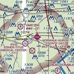
| Sectional chart |
|---|
|
| Airport distance calculator |
|---|
|
|
| Sunrise and sunset |
|---|
|
Times for 17-Feb-2026
| | Local
(UTC-5) | | Zulu
(UTC) |
|---|
| Morning civil twilight | | 06:55 | | 11:55 |
| Sunrise | | 07:23 | | 12:23 |
| Sunset | | 18:05 | | 23:05 |
| Evening civil twilight | | 18:33 | | 23:33 |
|
| Current date and time |
|---|
| Zulu (UTC) | 17-Feb-2026 06:23:59 |
|---|
| Local (UTC-5) | 17-Feb-2026 01:23:59 |
|---|
|
| METAR |
|---|
KLPR
18nm E | 170553Z AUTO 22009KT 5SM BR CLR 04/04 A3004 RMK AO2 SLP176 T00440039 10061 20044 55002 $
|
KPCW
22nm NW | 170545Z AUTO 23012KT 7SM CLR 06/05 A3001 RMK AO2
|
KMFD
26nm S | 170552Z AUTO 20012KT 5SM BR FEW006 04/03 A3004 RMK AO2 SLP179 T00390033 10061 20039 55001 $
|
KCLE
33nm E | 170551Z 20009KT 4SM BR BKN190 06/04 A3002 RMK AO2 SLP184 T00610044 10072 20061 55003 $
|
|
| TAF |
|---|
KMFD
26nm S | 170523Z 1706/1806 19014KT 5SM BR OVC006 TEMPO 1706/1710 1SM BR FM171500 20006KT 5SM BR BKN250 FM171800 19007KT P6SM BKN100
|
|
| NOTAMs |
|---|
NOTAMs are issued by the DoD/FAA and will open in a separate window not controlled by AirNav.
|
|


