FAA INFORMATION EFFECTIVE 22 JANUARY 2026
Location
| FAA Identifier: | 1G1 |
| Lat/Long: | 41-19-53.5000N 082-06-00.9000W
41-19.891667N 082-06.015000W
41.3315278,-82.1002500
(estimated) |
| Elevation: | 757.8 ft. / 231.0 m (surveyed) |
| Variation: | 06W (1985) |
| From city: | 2 miles S of ELYRIA, OH |
| Time zone: | UTC -5 (UTC -4 during Daylight Saving Time) |
| Zip code: | 44035 |
Airport Operations
| Airport use: | Open to the public |
| Activation date: | 04/1965 |
| Control tower: | no |
| ARTCC: | CLEVELAND CENTER |
| FSS: | CLEVELAND FLIGHT SERVICE STATION |
| NOTAMs facility: | CLE (NOTAM-D service available) |
| Attendance: | MON-FRI 0800-1700
UNATNDD MAJOR HOLS. |
| Wind indicator: | yes |
| Segmented circle: | no |
| Lights: | SS-SR |
| Beacon: | white-green (lighted land airport)
Operates sunset to sunrise. |
Airport Communications
| CTAF/UNICOM: | 122.8 |
| CLEVELAND APPROACH: | 125.35 |
| CLEVELAND DEPARTURE: | 125.35 |
| CLEARANCE DELIVERY: | 125.7 |
| WX ASOS at LPR (4 nm W): | 118.925 (440-323-7088) |
| WX ASOS at CLE (12 nm NE): | PHONE 216-264-9022 |
Nearby radio navigation aids
| VOR radial/distance | | VOR name | | Freq | | Var |
|---|
| DJBr125/3.2 | | DRYER VOR/DME | | 113.60 | | 05W |
Airport Services
| Fuel available: | 100LL
100LL:FUEL AVBL H24 VIA CREDIT CARD. |
| Airframe service: | MAJOR |
| Powerplant service: | MAJOR |
Runway Information
Runway 9/27
| Dimensions: | 3053 x 48 ft. / 931 x 15 m |
| Surface: | asphalt, in excellent condition |
| Runway edge lights: | non-standard
NSTD LIRL DUE TO 18 INCH NON-FRANGIBLE MOUNTING STAKES. |
| RUNWAY 9 | | RUNWAY 27 |
| Latitude: | 41-19.869633N | | 41-19.912683N |
| Longitude: | 082-06.347100W | | 082-05.682567W |
| Elevation: | 755.7 ft. | | 757.6 ft. |
| Traffic pattern: | left | | left |
| Runway heading: | 091 magnetic, 085 true | | 271 magnetic, 265 true |
| Markings: | basic, in good condition | | basic, in good condition |
| Runway end identifier lights: | no | | no |
| Touchdown point: | yes, no lights | | yes, no lights |
| Obstructions: | 85 ft. tree, 201 ft. from runway, 105 ft. right of centerline
10 FT BRUSH & 70 FT TREES, 100-199 FT DIST, 102 FT R. | | 85 ft. tree, 201 ft. from runway, 125 ft. left of centerline |
Airport Ownership and Management from official FAA records
| Ownership: | Privately-owned |
| Owner: | ELYRIA AIRPORT LIMITED
3593 MEDINA RD #319
MEDINA, OH 44256-8182
Phone 440-343-4943 |
| Manager: | ANGELO GOUSIOS
3593 MEDINA RD #319
MEDINA, OH 44256-8182
Phone 440-343-4943
OR 440-458-4215. |
Additional Remarks
| - | DEER & BIRDS ON & INVOF ARPT. |
| - | FOR CD CTC CLEVELAND APCH AT 216-352-2323. |
Instrument Procedures
NOTE: All procedures below are presented as PDF files. If you need a reader for these files, you should download the free Adobe Reader.NOT FOR NAVIGATION. Please procure official charts for flight.
FAA instrument procedures published for use from 22 January 2026 at 0901Z to 19 February 2026 at 0900z.
IAPs - Instrument Approach Procedures |
|---|
| VOR OR GPS-A | |
download (160KB) |
| NOTE: Special Take-Off Minimums/Departure Procedures apply | |
download (467KB) |
Other nearby airports with instrument procedures:
KLPR - Lorain County Regional Airport (4 nm W)
KCLE - Cleveland-Hopkins International Airport (12 nm NE)
1G5 - Medina Municipal Airport (19 nm SE)
5A1 - Norwalk/Huron County Airport (21 nm W)
KBKL - Burke Lakefront Airport (22 nm NE)
|
|

Road maps at:
MapQuest
Bing
Google
| Aerial photo |
|---|
WARNING: Photo may not be current or correct

Do you have a better or more recent aerial photo of Elyria Airport that you would like to share? If so, please send us your photo.
|
| Sectional chart |
|---|
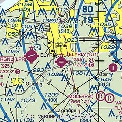
|
| Airport distance calculator |
|---|
|
|
| Sunrise and sunset |
|---|
|
Times for 16-Feb-2026
| | Local
(UTC-5) | | Zulu
(UTC) |
|---|
| Morning civil twilight | | 06:55 | | 11:55 |
| Sunrise | | 07:23 | | 12:23 |
| Sunset | | 18:02 | | 23:02 |
| Evening civil twilight | | 18:30 | | 23:30 |
|
| Current date and time |
|---|
| Zulu (UTC) | 16-Feb-2026 14:04:25 |
|---|
| Local (UTC-5) | 16-Feb-2026 09:04:25 |
|---|
|
| METAR |
|---|
KLPR
4nm W | 161353Z AUTO 18008KT M1/4SM FG VV002 00/00 A3004 RMK AO2 SLP180 T00000000
|
KCLE
12nm NE | 161351Z 19007KT 3/4SM BR OVC002 02/01 A3004 RMK AO2 SLP195 T00170011 $
|
|
| TAF |
|---|
KCLE
12nm NE | 161140Z 1612/1718 20006KT 5SM BR SCT005 TEMPO 1612/1613 1/2SM FG BKN003 FM161300 20008KT 3SM BR BKN006 FM161500 20008KT P6SM SCT015 FM161700 20012KT P6SM BKN200 FM170600 22007KT P6SM BKN040 FM171400 19005KT P6SM BKN025
|
|
| NOTAMs |
|---|
NOTAMs are issued by the DoD/FAA and will open in a separate window not controlled by AirNav.
|
|


