FAA INFORMATION EFFECTIVE 27 NOVEMBER 2025
Location
| FAA Identifier: | 19S |
| Lat/Long: | 37-29-48.7000N 100-49-58.5000W
37-29.811667N 100-49.975000W
37.4968611,-100.8329167
(estimated) |
| Elevation: | 2910.7 ft. / 887.2 m (surveyed) |
| Variation: | 09E (1985) |
| From city: | 1 mile NE of SUBLETTE, KS |
| Time zone: | UTC -6 (UTC -5 during Daylight Saving Time) |
| Zip code: | 67877 |
Airport Operations
| Airport use: | Open to the public |
| Activation date: | 06/1949 |
| Control tower: | no |
| ARTCC: | KANSAS CITY CENTER |
| FSS: | WICHITA FLIGHT SERVICE STATION |
| NOTAMs facility: | ICT (NOTAM-D service available) |
| Attendance: | UNATNDD |
| Wind indicator: | yes |
| Segmented circle: | no |
| Lights: | SS-SR |
Airport Communications
| CTAF: | 122.9 |
| UNICOM: | 122.8 |
| WX AWOS-3P: | 118.4 (620-290-3873) |
Nearby radio navigation aids
| VOR radial/distance | | VOR name | | Freq | | Var |
|---|
| GCKr180/25.8 | | GARDEN CITY VORTAC | | 113.30 | | 11E |
Airport Services
| Parking: | tiedowns |
| Airframe service: | NONE |
| Powerplant service: | NONE |
| Bottled oxygen: | NONE |
| Bulk oxygen: | NONE |
Runway Information
Runway 17/35
| Dimensions: | 4498 x 60 ft. / 1371 x 18 m |
| Surface: | asphalt, in good condition |
| Runway edge lights: | low intensity |
| Runway edge markings: | MKG FADED. |
| RUNWAY 17 | | RUNWAY 35 |
| Latitude: | 37-30.190053N | | 37-29.448953N |
| Longitude: | 100-50.058727W | | 100-50.057665W |
| Elevation: | 2909.5 ft. | | 2907.1 ft. |
| Traffic pattern: | left | | left |
| Markings: | basic, in poor condition | | basic, in poor condition |
| Runway end identifier lights: | no | | no |
| Touchdown point: | yes, no lights | | yes, no lights |
| Obstructions: | 17 ft. road, 201 ft. from runway, 96 ft. right of centerline
17 FT RD, 0-199 FT DSTC, 96 FT R. | | 17 ft. road, 201 ft. from runway, 96 ft. left of centerline
17 FT RD, 0-199 FT DSTC, 96 FT L. |
Runway 8/26
| Dimensions: | 2300 x 100 ft. / 701 x 30 m |
| Surface: | turf, in poor condition
SFC ROUGH. ANIMAL HOLES. |
| RUNWAY 8 | | RUNWAY 26 |
| Latitude: | 37-29.795930N | | 37-29.793807N |
| Longitude: | 100-50.052042W | | 100-49.576447W |
| Elevation: | 2908.7 ft. | | 2910.6 ft. |
| Traffic pattern: | left | | left |
| Markings: | , in fair condition | | , in fair condition |
| Runway end identifier lights: | no | | no |
| Touchdown point: | yes, no lights | | yes, no lights |
| Obstructions: | 17 ft. road, 125 ft. from runway, 145 ft. left and right of centerline, 7:1 slope to clear | | 10 ft. tower, 130 ft. from runway |
Airport Ownership and Management from official FAA records
| Ownership: | Publicly-owned |
| Owner: | CITY OF SUBLETTE
103 CODY STREET, BOX 934
SUBLETTE, KS 67877
Phone 620-675-2326 |
| Manager: | DAYLEN ELSEY
BOX 934
SUBLETTE, KS 67877
Phone 620-675-2326 |
Additional Remarks
| - | 150 FT LGTD GRAIN ELEVATOR S OF RWY 08/26, 2750 FT. |
| - | FOR CD CTC KANSAS CITY ARTCC AT 913-254-8508. |
Instrument Procedures
There are no published instrument procedures at 19S.
Some nearby airports with instrument procedures:
KMEJ - Meade Municipal Airport (26 nm SE)
KGCK - Garden City Regional Airport (26 nm N)
KULS - Ulysses Airport (27 nm W)
KLBL - Liberal Mid-America Regional Airport (28 nm S)
KHQG - Hugoton Municipal Airport (33 nm SW)
|
|

Road maps at:
MapQuest
Bing
Google
| Aerial photo |
|---|
WARNING: Photo may not be current or correct
 Photo by Von Rothenberger
Photo taken 13-Aug-2010
looking south.
Photo by Von Rothenberger
Photo taken 13-Aug-2010
looking south.
Do you have a better or more recent aerial photo of Sublette Municipal Airport that you would like to share? If so, please send us your photo.
|
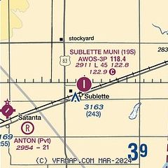
| Sectional chart |
|---|
|
| Airport distance calculator |
|---|
|
|
| Sunrise and sunset |
|---|
|
Times for 08-Dec-2025
| | Local
(UTC-6) | | Zulu
(UTC) |
|---|
| Morning civil twilight | | 07:17 | | 13:17 |
| Sunrise | | 07:47 | | 13:47 |
| Sunset | | 17:24 | | 23:24 |
| Evening civil twilight | | 17:53 | | 23:53 |
|
| Current date and time |
|---|
| Zulu (UTC) | 08-Dec-2025 13:40:15 |
|---|
| Local (UTC-6) | 08-Dec-2025 07:40:15 |
|---|
|
| METAR |
|---|
| K19S | 081310Z AUTO 23009KT 10SM CLR M01/M03 A3019 RMK AO2 T10141034
|
|
| TAF |
|---|
KGCK
26nm N | 081120Z 0812/0912 24010KT P6SM FEW250 FM081900 27012KT P6SM SKC FM090700 26007KT P6SM FEW250
|
KLBL
29nm S | 081120Z 0812/0912 23005KT P6SM SKC FM081700 27007KT P6SM FEW250
|
|
| NOTAMs |
|---|
NOTAMs are issued by the DoD/FAA and will open in a separate window not controlled by AirNav.
|
|


