FAA INFORMATION EFFECTIVE 16 APRIL 2026
Location
| FAA Identifier: | HQG |
| Lat/Long: | 37-09-48.0900N 101-22-14.4390W
37-09.801500N 101-22.240650W
37.1633583,-101.3706775
(estimated) |
| Elevation: | 3134.3 ft. / 955.3 m (surveyed) |
| Variation: | 05E (2025) |
| From city: | 2 miles SW of HUGOTON, KS |
| Time zone: | UTC -5 (UTC -6 during Standard Time) |
| Zip code: | 67951 |
Airport Operations
| Airport use: | Open to the public |
| Activation date: | 12/1946 |
| Control tower: | no |
| ARTCC: | KANSAS CITY CENTER |
| FSS: | WICHITA FLIGHT SERVICE STATION |
| NOTAMs facility: | ICT (NOTAM-D service available) |
| Attendance: | MON-SAT 0800-1700 |
| Wind indicator: | lighted |
| Segmented circle: | yes |
| Lights: | ACTVT PAPI RWYS 02 & 20; HIRL RWY 02/20 - CTAF. |
| Beacon: | white-green (lighted land airport)
Operates sunset to sunrise. |
Airport Communications
| CTAF/UNICOM: | 122.8 |
| WX AWOS-3PT: | 118.600 (620-544-4000) |
- APCH/DEP CTL SVC PRVDD BY KANSAS CITY ARTCC (ZKC) ON FREQS 134.0/257.625 (LIBERAL RCAG).
Airport Services
| Fuel available: | 100LL |
| Parking: | hangars and tiedowns |
| Airframe service: | NONE |
| Powerplant service: | NONE |
| Bottled oxygen: | NONE |
| Bulk oxygen: | NONE |
Runway Information
Runway 2/20
| Dimensions: | 5000 x 75 ft. / 1524 x 23 m |
| Surface: | concrete, in fair condition |
| Weight bearing capacity: | | PCN 11 /R/C/X/U | | Single wheel: | 30.0 |
|
| Runway edge lights: | high intensity |
| RUNWAY 2 | | RUNWAY 20 |
| Latitude: | 37-09.333212N | | 37-10.082003N |
| Longitude: | 101-22.472608W | | 101-22.043282W |
| Elevation: | 3133.4 ft. | | 3129.7 ft. |
| Traffic pattern: | left | | left |
| Runway heading: | 020 magnetic, 025 true | | 200 magnetic, 205 true |
| Markings: | nonprecision, in good condition | | nonprecision, in good condition |
| Visual slope indicator: | 2-light PAPI on left (3.00 degrees glide path) | | 2-light PAPI on left (3.00 degrees glide path) |
| Runway end identifier lights: | no | | no |
| Touchdown point: | yes, no lights | | yes, no lights |
| Obstructions: | 17 ft. road, 758 ft. from runway, 32:1 slope to clear | | 15 ft. road, 613 ft. from runway, 316 ft. right of centerline, 27:1 slope to clear |
Runway 13/31
| Dimensions: | 3039 x 60 ft. / 926 x 18 m |
| Surface: | asphalt, in good condition |
| Weight bearing capacity: | |
| RUNWAY 13 | | RUNWAY 31 |
| Latitude: | 37-10.133498N | | 37-09.778388N |
| Longitude: | 101-22.432757W | | 101-21.991558W |
| Elevation: | 3129.4 ft. | | 3127.7 ft. |
| Traffic pattern: | left | | left |
| Runway heading: | 130 magnetic, 135 true | | 310 magnetic, 315 true |
| Displaced threshold: | 412 ft. | | 202 ft. |
| Markings: | basic, in good condition | | basic, in good condition |
| Touchdown point: | yes, no lights | | yes, no lights |
| Obstructions: | 17 ft. road, 503 ft. from runway, 17:1 slope to clear | | none |
Airport Ownership and Management from official FAA records
| Ownership: | Publicly-owned |
| Owner: | STEVENS COUNTY
P.O. BOX 130
HUGOTON, KS 67951
Phone 620-544-2541 |
| Manager: | SCOTT SPIKES
BOX 130
HUGOTON, KS 67951
Phone 620-544-7600 |
Additional Remarks
| - | FOR CD CTC KANSAS CITY ARTCC AT 913-254-8508. |
Instrument Procedures
NOTE: All procedures below are presented as PDF files. If you need a reader for these files, you should download the free Adobe Reader.NOT FOR NAVIGATION. Please procure official charts for flight.
FAA instrument procedures published for use from 16 April 2026 at 0901Z to 14 May 2026 at 0900Z.
IAPs - Instrument Approach Procedures |
|---|
| RNAV (GPS) RWY 02 | |
download (204KB) |
| RNAV (GPS) RWY 20 | |
download (215KB) |
| NOTE: Special Alternate Minimums apply | |
download (145KB) |
| NOTE: Special Take-Off Minimums/Departure Procedures apply | |
download (358KB) |
Other nearby airports with instrument procedures:
KLBL - Liberal Mid-America Regional Airport (21 nm E)
KEHA - Elkhart-Morton County Airport (26 nm W)
KULS - Ulysses Airport (26 nm N)
KGUY - Guymon Municipal Airport (29 nm S)
KJHN - Stanton County Municipal Airport (31 nm NW)
|
|

Road maps at:
MapQuest
Bing
Google
| Aerial photo |
|---|
WARNING: Photo may not be current or correct
 Photo by MItch Bowers; Imagewerx.us
Photo taken 12-Jan-2012
looking southeast from 6000 MSL
Photo by MItch Bowers; Imagewerx.us
Photo taken 12-Jan-2012
looking southeast from 6000 MSL
Do you have a better or more recent aerial photo of Hugoton Municipal Airport that you would like to share? If so, please send us your photo.
|
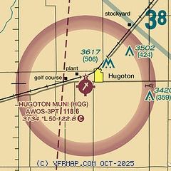
| Sectional chart |
|---|
|
| Airport distance calculator |
|---|
|
|
| Sunrise and sunset |
|---|
|
Times for 03-May-2026
| | Local
(UTC-5) | | Zulu
(UTC) |
|---|
| Morning civil twilight | | 06:21 | | 11:21 |
| Sunrise | | 06:50 | | 11:50 |
| Sunset | | 20:35 | | 01:35 |
| Evening civil twilight | | 21:03 | | 02:03 |
|
| Current date and time |
|---|
| Zulu (UTC) | 03-May-2026 11:03:47 |
|---|
| Local (UTC-5) | 03-May-2026 06:03:47 |
|---|
|
| METAR |
|---|
| KHQG | 031055Z AUTO 23010KT 10SM CLR 05/M00 A3002 RMK AO2
|
|
| TAF |
|---|
KLBL
21nm E | 030520Z 0306/0406 VRB06KT P6SM SKC FM031300 24012KT P6SM FEW250 FM031500 23016G26KT P6SM FEW250 FM032200 22012KT P6SM FEW250
|
|
| NOTAMs |
|---|
NOTAMs are issued by the DoD/FAA and will open in a separate window not controlled by AirNav.
|
|


