FAA INFORMATION EFFECTIVE 27 NOVEMBER 2025
Location
| FAA Identifier: | 1B2 |
| Lat/Long: | 41-21-30.4220N 070-31-28.0940W
41-21.507033N 070-31.468233W
41.3584506,-70.5244706
(estimated) |
| Elevation: | 18 ft. / 5 m (estimated) |
| Variation: | 16W (1985) |
| From city: | 2 miles S of EDGARTOWN, MA |
| Time zone: | UTC -5 (UTC -4 during Daylight Saving Time) |
| Zip code: | 02539 |
Airport Operations
| Airport use: | Open to the public |
| Activation date: | 04/1940 |
| Control tower: | no |
| ARTCC: | BOSTON CENTER |
| FSS: | BRIDGEPORT FLIGHT SERVICE STATION |
| NOTAMs facility: | BDR (NOTAM-D service available) |
| Attendance: | MAY 15 - OCT 15 SR-SS |
| Wind indicator: | yes |
| Segmented circle: | no |
| Landing fee: | yes |
Airport Communications
| CTAF/UNICOM: | 122.8 |
| BOSTON APPROACH: | 119.7 |
| BOSTON DEPARTURE: | 119.7 |
| WX ASOS at MVY (5 nm NW): | 126.25 (508-696-6988) |
| WX ASOS at FMH (18 nm N): | PHONE 508-968-6562 |
Nearby radio navigation aids
| VOR radial/distance | | VOR name | | Freq | | Var |
|---|
| MVYr135/4.6 | | MARTHAS VINEYARD VOR/DME | | 114.50 | | 15W |
| ACKr297/22.9 | | NANTUCKET VOR/DME | | 116.20 | | 15W |
| NDB name | | Hdg/Dist | | Freq | | Var | | ID |
|---|
| NAUSET | | 246/31.3 | | 279 | | 16W | | CQX | -.-. --.- -..- |
Airport Services
| Fuel available: | 100LL |
| Parking: | tiedowns |
| Airframe service: | NONE |
| Powerplant service: | NONE |
| Bottled oxygen: | NONE |
| Bulk oxygen: | NONE |
Runway Information
Runway 3/21
| Dimensions: | 3700 x 50 ft. / 1128 x 15 m
RWY REMEASURED W/ ENGINEERING WHEEL |
| Surface: | turf, in good condition |
| Runway edge markings: | DSPLCD THR MKD WITH FLUSH WHITE PAVING BLOCKS. |
| RUNWAY 3 | | RUNWAY 21 |
| Traffic pattern: | left | | left |
| Displaced threshold: | 245 ft. | | 300 ft. |
| Markings: | NSTD, in fair condition | | NSTD, in fair condition |
| Obstructions: | 15 ft. road, 85 ft. left of centerline
APCH RATIO 16:1 TO DSPLCD THR. | | 12 ft. pole, 112 ft. from runway, 9:1 slope to clear
RWY 21 APCH RATIO 34:1 TO DSPLCD THR. |
Runway 6/24
| Dimensions: | 2700 x 50 ft. / 823 x 15 m |
| Surface: | turf, in good condition |
| Runway edge markings: | DSPLCD THR MKD WITH FLUSH WHITE PAVING BLOCKS. |
| RUNWAY 6 | | RUNWAY 24 |
| Traffic pattern: | left | | left |
| Displaced threshold: | 300 ft. | | no |
| Markings: | NSTD, in fair condition | | NSTD, in fair condition |
| Obstructions: | 15 ft. road, 150 ft. from runway, 10:1 slope to clear
APCH RATIO 30:1 TO DSPLCD THR. | | 10 ft. road, 100 ft. from runway, 10:1 slope to clear |
Runway 17/35
| Dimensions: | 2600 x 50 ft. / 792 x 15 m |
| Surface: | turf, in good condition |
| Runway edge markings: | DSPLCD THR MKD WITH FLUSH WHITE PAVING BLOCKS. |
| RUNWAY 17 | | RUNWAY 35 |
| Traffic pattern: | left | | left |
| Displaced threshold: | 200 ft. | | no |
| Markings: | NSTD, in fair condition | | NSTD, in fair condition |
| Obstructions: | 25 ft. bldg, 500 ft. from runway, 35 ft. right of centerline, 20:1 slope to clear
APCH RATIO 35:1 TO DSPLCD THR. | | none |
Airport Ownership and Management from official FAA records
| Ownership: | Publicly-owned |
| Owner: | TOWN OF EDGARTOWN
PO BOX 5158
EDGARTOWN, MA 02539
Phone (508) 627-6180
AIRFIELD@EDGARTOWN-MA.US |
| Manager: | BRIAN MCCABE
KATAMA AIRPARK, 12 MATTAKESETT WAY
EDGARTOWN, MA 02539
Phone (508) 627-0421 |
Additional Remarks
| - | BE AWARE OF HIGH-SPD MIL JET & HVY HEL TFC VCNTY CAPE COD CGAS. |
| - | WILDLIFE ON AND INVOF ARPT. |
| - | FOR CD CTC BOSTON APCH AT 603-594-5554. |
Instrument Procedures
There are no published instrument procedures at 1B2.
Some nearby airports with instrument procedures:
KMVY - Martha's Vineyard Airport (5 nm NW)
5B6 - Falmouth Airpark (14 nm N)
KFMH - Cape Cod Coast Guard Air Station (18 nm N)
KHYA - Cape Cod Gateway Airport (22 nm NE)
KACK - Nantucket Memorial Airport (22 nm E)
|
|

Road maps at:
MapQuest
Bing
Google
| Aerial photo |
|---|
WARNING: Photo may not be current or correct
 Photo by Karl Swenson
Photo taken 09-Mar-2020
looking northeast.
Photo by Karl Swenson
Photo taken 09-Mar-2020
looking northeast.
Do you have a better or more recent aerial photo of Katama Airpark that you would like to share? If so, please send us your photo.
|
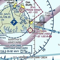
| Sectional chart |
|---|
|
| Airport distance calculator |
|---|
|
|
| Sunrise and sunset |
|---|
|
Times for 08-Dec-2025
| | Local
(UTC-5) | | Zulu
(UTC) |
|---|
| Morning civil twilight | | 06:25 | | 11:25 |
| Sunrise | | 06:56 | | 11:56 |
| Sunset | | 16:12 | | 21:12 |
| Evening civil twilight | | 16:43 | | 21:43 |
|
| Current date and time |
|---|
| Zulu (UTC) | 08-Dec-2025 23:46:31 |
|---|
| Local (UTC-5) | 08-Dec-2025 18:46:31 |
|---|
|
| METAR |
|---|
KMVY
5nm NW | 082253Z AUTO 34009KT 10SM CLR M04/M18 A3024 RMK AO2 SLP239 T10441183
|
KFMH
16nm N | 082256Z 32007KT 10SM CLR M06/M18 A3024
|
|
| TAF |
|---|
KFMH
16nm N | 081720Z 0818/0918 34013G25KT P6SM SCT060 FM082300 34009KT P6SM SCT140 FM091600 27005KT P6SM FEW200 AMD NOT SKED
|
|
| NOTAMs |
|---|
NOTAMs are issued by the DoD/FAA and will open in a separate window not controlled by AirNav.
|
|

