FAA INFORMATION EFFECTIVE 16 APRIL 2026
Location
| FAA Identifier: | MVY |
| Lat/Long: | 41-23-36.3030N 070-36-49.9480W
41-23.605050N 070-36.832467W
41.3934175,-70.6138744
(estimated) |
| Elevation: | 66.9 ft. / 20.4 m (surveyed) |
| Variation: | 15W (1980) |
| From city: | 3 miles S of VINEYARD HAVEN, MA |
| Time zone: | UTC -4 (UTC -5 during Standard Time) |
| Zip code: | 02568 |
Airport Operations
| Airport use: | Open to the public |
| Activation date: | 07/1974 |
| Control tower: | yes |
| ARTCC: | BOSTON CENTER |
| FSS: | BRIDGEPORT FLIGHT SERVICE STATION |
| NOTAMs facility: | MVY (NOTAM-D service available) |
| Attendance: | CONTINUOUS |
| Wind indicator: | lighted |
| Segmented circle: | yes |
| Lights: | WHEN ATCT CLSD ACTVT MALSR RWY 24; REIL RWY 33; HIRL RWY 06/24; MIRL RWY 15/33 - CTAF. |
| Beacon: | white-green (lighted land airport)
Operates sunset to sunrise. |
| Landing fee: | yes, PRKG FEE ALL ACFT. LDG FEE ALL ACFT OVER 4000 LBS. |
| Fire and rescue: | ARFF index B |
| Airline operations: | 24-HR PPR FOR UNSKED ACR OPS WITH MORE THAN 9 PAX SEATS-CALL AMGR 508-693-7022. |
Airport Communications
| CTAF: | 121.4 |
| UNICOM: | 122.95 |
| ATIS: | 126.25 |
| WX ASOS: | 126.25 (508-696-6988) |
| VINEYARD GROUND: | 124.35 [0600-2200 MAY 15 - OCT 31; 0700-1700 NOV 1 MAY14] |
| VINEYARD TOWER: | 121.4 [0600-2200 MAY 15 - OCT 31; 0700-1700 NOV 1 MAY14] |
| BOSTON APPROACH: | 133.75 |
| BOSTON DEPARTURE: | 133.75 |
| CLEARANCE DELIVERY: | 124.35 119.7 ;WHEN TWR CLSD |
| EMERG: | 121.5 |
| WX ASOS at FMH (16 nm N): | PHONE 508-968-6562 |
Nearby radio navigation aids
| VOR radial/distance | | VOR name | | Freq | | Var |
|---|
| MVY at field | | MARTHAS VINEYARD VOR/DME | | 114.50 | | 15W |
| ACKr299/27.3 | | NANTUCKET VOR/DME | | 116.20 | | 15W |
| NDB name | | Hdg/Dist | | Freq | | Var | | ID |
|---|
| NAUSET | | 254/33.3 | | 279 | | 16W | | CQX | -.-. --.- -..- |
Airport Services
| Fuel available: | 100LL JET-A |
| Parking: | tiedowns |
| Airframe service: | MINOR |
| Powerplant service: | MINOR |
| Bottled oxygen: | NONE |
| Bulk oxygen: | NONE |
Runway Information
Runway 6/24
| Dimensions: | 5504 x 100 ft. / 1678 x 30 m |
| Surface: | asphalt/grooved, in fair condition |
| Weight bearing capacity: | | Single wheel: | 65.0 | | Double wheel: | 108.0 | | Double tandem: | 185.0 |
|
| Runway edge lights: | high intensity |
| RUNWAY 6 | | RUNWAY 24 |
| Latitude: | 41-23.199300N | | 41-23.887297N |
| Longitude: | 070-37.160047W | | 070-36.376582W |
| Elevation: | 53.9 ft. | | 62.6 ft. |
| Traffic pattern: | left | | right |
| Runway heading: | 056 magnetic, 041 true | | 236 magnetic, 221 true |
| Declared distances: | TORA:5504 TODA:5504 ASDA:5504 LDA:5504 | | TORA:5504 TODA:5504 ASDA:5504 LDA:5504 |
| Markings: | precision, in good condition | | precision, in good condition |
| Visual slope indicator: | 4-light PAPI on right (3.00 degrees glide path) | | 4-light PAPI on right (3.00 degrees glide path) |
| RVR equipment: | rollout | | touchdown |
| Approach lights: | | | MALSR: 1,400 foot medium intensity approach lighting system with runway alignment indicator lights |
| Runway end identifier lights: | yes | | |
| Touchdown point: | yes, no lights | | yes, no lights |
| Instrument approach: | | | ILS/DME |
| Obstructions: | 14 ft. trees, 700 ft. from runway, 350 ft. right of centerline, 34:1 slope to clear | | none |
Runway 15/33
| Dimensions: | 3327 x 75 ft. / 1014 x 23 m |
| Surface: | asphalt, in good condition |
| Weight bearing capacity: | | Single wheel: | 31.0 | | Double wheel: | 45.0 | | Double tandem: | 61.0 |
|
| Runway edge lights: | medium intensity |
| Operational restrictions: | RWY 15/33 NOT AVBL FOR PART 121/PART 380 OPS WITH SKED PAX CARRYING OPS MORE THAN 9 PAX SEATS AND NON-SKED PAX CARRYING OPS MORE THAN 30 PAX SEATS. |
| RUNWAY 15 | | RUNWAY 33 |
| Latitude: | 41-23.885530N | | 41-23.528860N |
| Longitude: | 070-37.214692W | | 070-36.662440W |
| Elevation: | 66.9 ft. | | 56.9 ft. |
| Traffic pattern: | left | | right |
| Runway heading: | 146 magnetic, 131 true | | 326 magnetic, 311 true |
| Declared distances: | TORA:3327 TODA:3327 ASDA:3327 LDA:3327 | | TORA:3327 TODA:3327 ASDA:3327 LDA:3327 |
| Markings: | nonprecision, in good condition | | nonprecision, in good condition |
| Runway end identifier lights: | | | yes |
| Touchdown point: | yes, no lights | | yes, no lights |
| Obstructions: | 40 ft. trees, 1500 ft. from runway, 34:1 slope to clear | | 52 ft. trees, 2000 ft. from runway, 175 ft. right of centerline, 34:1 slope to clear |
Airport Ownership and Management from official FAA records
| Ownership: | Publicly-owned |
| Owner: | COUNTY OF DUKES COUNTY
71 AIRPORT RD
VINEYARD HAVEN, MA 02568
Phone 508-693-7022 |
| Manager: | GEOFFREY R. FREEMAN
71 AIRPORT RD
VINEYARD HAVEN, MA 02568
Phone 508-693-7022 |
Additional Remarks
| A39-06/24 | PCR VALUE: 200/F/A/X/T |
| A39-15/33 | PCR VALUE: 90/F/A/X/T |
| - | TWY D FM RWY 06 TO RWY 15 CLSD TO ACFT WITH OVR 9 PAX. |
| - | ARPT HAS NOISE ABATEMENT PROCS. CTC OPNS 508-693-7022. AVOID RESIDENTIAL AREAS SW OF ARPT. |
| - | HELS PROHIBITED FM HOVER TAXI, LDG AND TKOF FM T-HNGRS. |
| - | CURFEW ON ARRS & DEPS BTN 2200-0600. |
Instrument Procedures
NOTE: All procedures below are presented as PDF files. If you need a reader for these files, you should download the free Adobe Reader.NOT FOR NAVIGATION. Please procure official charts for flight.
FAA instrument procedures published for use from 16 April 2026 at 0901Z to 14 May 2026 at 0900Z.
IAPs - Instrument Approach Procedures |
|---|
| ILS OR LOC RWY 24 | |
download (343KB) |
| RNAV (GPS) RWY 06 | |
download (269KB) |
| RNAV (GPS) RWY 15 | |
download (291KB) |
| RNAV (GPS) RWY 24 | |
download (339KB) |
| RNAV (GPS) RWY 33 | |
download (267KB) |
| VOR RWY 06 | |
download (231KB) |
| NOTE: Special Alternate Minimums apply | |
download (147KB) |
| NOTE: Special Take-Off Minimums/Departure Procedures apply | |
download (178KB) |
Other nearby airports with instrument procedures:
5B6 - Falmouth Airpark (12 nm N)
KFMH - Cape Cod Coast Guard Air Station (16 nm N)
KHYA - Cape Cod Gateway Airport (22 nm NE)
KEWB - New Bedford Regional Airport (23 nm NW)
KACK - Nantucket Memorial Airport (26 nm E)
|
|

Road maps at:
MapQuest
Bing
Google
| Aerial photo |
|---|
WARNING: Photo may not be current or correct
 Photo by David Newcomer
Photo taken 24-Feb-2020
from 3,000' altitude looking northeast.
Photo by David Newcomer
Photo taken 24-Feb-2020
from 3,000' altitude looking northeast.
Do you have a better or more recent aerial photo of Martha's Vineyard Airport that you would like to share? If so, please send us your photo.
|
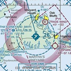
| Sectional chart |
|---|
|
| Airport distance calculator |
|---|
|
|
| Sunrise and sunset |
|---|
|
Times for 27-Apr-2026
| | Local
(UTC-4) | | Zulu
(UTC) |
|---|
| Morning civil twilight | | 05:16 | | 09:16 |
| Sunrise | | 05:46 | | 09:46 |
| Sunset | | 19:34 | | 23:34 |
| Evening civil twilight | | 20:04 | | 00:04 |
|
| Current date and time |
|---|
| Zulu (UTC) | 28-Apr-2026 02:11:04 |
|---|
| Local (UTC-4) | 27-Apr-2026 22:11:04 |
|---|
|
| METAR |
|---|
| KMVY | 280153Z AUTO 02006KT 10SM CLR 07/04 A3025 RMK AO2 SLP244 T00670039
|
KFMH
15nm N | 280155Z 05004KT 10SM CLR 07/04 A3027
|
|
| TAF |
|---|
KFMH
15nm N | 271720Z 2718/2818 06011G19KT P6SM SKC FM272300 05005KT P6SM SKC FM281200 05007KT P6SM FEW250 FM281700 05012KT P6SM FEW250
|
|
| NOTAMs |
|---|
NOTAMs are issued by the DoD/FAA and will open in a separate window not controlled by AirNav.
|
|


