FAA INFORMATION EFFECTIVE 27 NOVEMBER 2025
Location
| FAA Identifier: | 5B6 |
| Lat/Long: | 41-35-08.1000N 070-32-25.3000W
41-35.135000N 070-32.421667W
41.5855833,-70.5403611
(estimated) |
| Elevation: | 41 ft. / 12.5 m (surveyed) |
| Variation: | 16W (1985) |
| From city: | 4 miles NE of FALMOUTH, MA |
| Time zone: | UTC -5 (UTC -4 during Daylight Saving Time) |
| Zip code: | 02536 |
Airport Operations
| Airport use: | Open to the public |
| Activation date: | 08/1959 |
| Control tower: | no |
| ARTCC: | BOSTON CENTER |
| FSS: | BRIDGEPORT FLIGHT SERVICE STATION |
| NOTAMs facility: | BDR (NOTAM-D service available) |
| Attendance: | 0800 - 1600 |
| Wind indicator: | yes |
| Segmented circle: | yes |
| Lights: | ACTVT LIRL RWY 07/25 - 122.7. |
| Beacon: | white-green (lighted land airport)
Operates sunset to sunrise. |
| Landing fee: | yes |
Airport Communications
| CTAF/UNICOM: | 123.075 |
| BOSTON APPROACH: | 118.2 |
| BOSTON DEPARTURE: | 118.2 |
| WX ASOS at FMH (4 nm N): | PHONE 508-968-6562 |
| WX ASOS at MVY (12 nm S): | 126.25 (508-696-6988) |
| WX ASOS at HYA (13 nm NE): | PHONE 508-862-2601 |
| WX ASOS at EWB (20 nm W): | 126.85 (508-992-0195) |
Nearby radio navigation aids
| VOR radial/distance | | VOR name | | Freq | | Var |
|---|
| MVYr031/11.8 | | MARTHAS VINEYARD VOR/DME | | 114.50 | | 15W |
| ACKr323/29.4 | | NANTUCKET VOR/DME | | 116.20 | | 15W |
| LFVr237/34.3 | | MARCONI VOR/DME | | 114.70 | | 16W |
| NDB name | | Hdg/Dist | | Freq | | Var | | ID |
|---|
| NAUSET | | 272/25.6 | | 279 | | 16W | | CQX | -.-. --.- -..- |
| PROVINCETOWN | | 222/32.3 | | 389 | | 16W | | PVC | .--. ...- -.-. |
Airport Services
| Fuel available: | 100LL UL94 |
| Parking: | tiedowns |
| Airframe service: | NONE |
| Powerplant service: | NONE |
| Bottled oxygen: | NONE |
| Bulk oxygen: | NONE |
Runway Information
Runway 7/25
| Dimensions: | 2298 x 40 ft. / 700 x 12 m |
| Surface: | asphalt, in good condition |
| Weight bearing capacity: | |
| Runway edge lights: | low intensity |
| RUNWAY 7 | | RUNWAY 25 |
| Latitude: | 41-35.016423N | | 41-35.252345N |
| Longitude: | 070-32.617743W | | 070-32.223817W |
| Elevation: | 38.0 ft. | | 41.0 ft. |
| Traffic pattern: | right | | left |
| Runway heading: | 067 magnetic, 051 true | | 247 magnetic, 231 true |
| Markings: | nonprecision, in good condition | | nonprecision, in good condition |
| Touchdown point: | yes, no lights | | yes, no lights |
| Obstructions: | 56 ft. trees, 1014 ft. from runway, 116 ft. right of centerline, 14:1 slope to clear | | 25 ft. trees, 300 ft. from runway, 125 ft. right of centerline, 4:1 slope to clear |
Airport Ownership and Management from official FAA records
| Ownership: | Privately-owned |
| Owner: | FALMOUTH AIRPARK HOMEOWNERS ASSOC
67 AIRPARK DR
E FALMOUTH, MA 02536
Phone 508-548-9617 |
| Manager: | ADAM PERRY
67 AIRPARK DR
E FALMOUTH, MA 02536
Phone 508-548-9617 |
Additional Remarks
| - | BE AWARE OF HIGH-SPD MIL JET & HVY HEL TFC INVOF CAPE COD CGAS. |
| - | WATCH FOR PEDESTRIANS OR ANIMALS INVOF RWY. |
| - | ACTVT RWY LGTS WITH 5 CLICKS ON FREQ 122.7. |
| - | NON-STD YELLOW CHEVRONS AT APCH END OF RWY 07 & 25. |
| - | TIE DOWN ROPES AVBL IN FUEL SHED. |
| - | SELF SVC 100LL & UL94 AVBL WITH CREDIT CARD. |
| - | RWY 7/25 NON-STD LIRL RWY LGTS. LGTS OFFSET 40 FT N OF RWY EDGE. |
| - | FEE FOR OVNGT PRKG. |
| - | LDG FEE FOR COML OPS. |
| - | ARPT CLSD TO ACFT EXCEEDING 5000 LBS PUBLD MAX GWT. |
| - | TURF ARND RWY 07/25 SOFT AFT RAIN. |
| - | TSNT OPS DAYTIME ONLY. NO NGT TSNT TKOFS OR LNDGS. |
| - | NO TSNT STUDENT ACTS, SOLO OR DUAL AT 5B6. |
| - | FULL STOPS ONLY. TGL OPS PROHIBITED. |
| - | WILDLIFE INVOF ARPT. |
| - | FOR CD CTC BOSTON APCH AT 603-594-5554. |
Instrument Procedures
NOTE: All procedures below are presented as PDF files. If you need a reader for these files, you should download the free Adobe Reader.NOT FOR NAVIGATION. Please procure official charts for flight.
FAA instrument procedures published for use from 27 November 2025 at 0901Z to 25 December 2025 at 0900Z.
IAPs - Instrument Approach Procedures |
|---|
| RNAV (GPS) RWY 07 | |
download (249KB) |
| RNAV (GPS) RWY 25 | |
download (205KB) |
| NOTE: Special Take-Off Minimums/Departure Procedures apply | |
download (514KB) |
Other nearby airports with instrument procedures:
KFMH - Cape Cod Coast Guard Air Station (4 nm N)
KMVY - Martha's Vineyard Airport (12 nm S)
KHYA - Cape Cod Gateway Airport (13 nm NE)
KEWB - New Bedford Regional Airport (20 nm W)
KPYM - Plymouth Municipal Airport (21 nm NW)
|
|

Road maps at:
MapQuest
Bing
Google
| Aerial photo |
|---|
WARNING: Photo may not be current or correct
 Photo by Margot Cheel margotcheel.com
Photo taken 16-Sep-2012
looking east-northeast.
Photo by Margot Cheel margotcheel.com
Photo taken 16-Sep-2012
looking east-northeast.
Do you have a better or more recent aerial photo of Falmouth Airpark that you would like to share? If so, please send us your photo.
|
| Sectional chart |
|---|
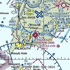
|
| Airport distance calculator |
|---|
|
|
| Sunrise and sunset |
|---|
|
Times for 04-Dec-2025
| | Local
(UTC-5) | | Zulu
(UTC) |
|---|
| Morning civil twilight | | 06:22 | | 11:22 |
| Sunrise | | 06:53 | | 11:53 |
| Sunset | | 16:11 | | 21:11 |
| Evening civil twilight | | 16:42 | | 21:42 |
|
| Current date and time |
|---|
| Zulu (UTC) | 04-Dec-2025 11:36:37 |
|---|
| Local (UTC-5) | 04-Dec-2025 06:36:37 |
|---|
|
| METAR |
|---|
KFMH
3nm N | 041055Z 20004KT 10SM CLR M02/M03 A2996
|
KMVY
12nm S | 041053Z AUTO 23008G17KT 10SM CLR 04/M01 A2995 RMK AO2 SLP143 T00391011
|
KHYA
13nm E | 041056Z 25004KT 10SM CLR M02/M04 A2993 RMK AO2 SLP137 I1000 T10221039 $
|
KEWB
19nm W | 041053Z AUTO 24006KT 10SM CLR 00/M03 A2994 RMK AO2 SLP140 T00001033
|
|
| TAF |
|---|
KFMH
3nm N | 040536Z 0406/0506 24003KT P6SM FEW035 SCT150 FM041300 25008KT P6SM SCT150 FM041500 26013G24KT P6SM BKN150 FM042100 28015G32KT P6SM BKN060 FM050400 32012G23KT P6SM SKC
|
KHYA
13nm E | 040536Z 0406/0506 23004KT P6SM SCT150 BKN200 FM041400 25012KT P6SM BKN150 FM041600 26014G26KT P6SM BKN050 FM042100 28015G34KT P6SM SCT050 FM050400 32013G25KT P6SM SKC
|
|
| NOTAMs |
|---|
NOTAMs are issued by the DoD/FAA and will open in a separate window not controlled by AirNav.
|
|

