FAA INFORMATION EFFECTIVE 22 JANUARY 2026
Location
| FAA Identifier: | PYM |
| Lat/Long: | 41-54-31.6380N 070-43-39.4610W
41-54.527300N 070-43.657683W
41.9087883,-70.7276281
(estimated) |
| Elevation: | 148.1 ft. / 45.1 m (surveyed) |
| Variation: | 16W (1995) |
| From city: | 4 miles SW of PLYMOUTH, MA |
| Time zone: | UTC -5 (UTC -4 during Daylight Saving Time) |
| Zip code: | 02360 |
Airport Operations
| Airport use: | Open to the public |
| Activation date: | 03/1941 |
| Control tower: | no |
| ARTCC: | BOSTON CENTER |
| FSS: | BRIDGEPORT FLIGHT SERVICE STATION |
| NOTAMs facility: | PYM (NOTAM-D service available) |
| Attendance: | 0600-2200 |
| Wind indicator: | yes |
| Segmented circle: | yes |
| Lights: | ACTVT MALSF RWY 06; REIL RWY 24; PAPI RWY 06, 24 & 33; MIRL RWY 06/24 & 15/33 - 122.9. |
| Beacon: | white-green (lighted land airport)
Operates sunset to sunrise. |
Airport Communications
| CTAF/UNICOM: | 122.725 |
| WX ASOS: | 135.625 (508-732-8358) |
| BOSTON APPROACH: | 118.2 |
| BOSTON DEPARTURE: | 118.2 |
| CLEARANCE DELIVERY: | 127.75 |
| WX AWOS-3 at GHG (12 nm N): | 120.0 (781-837-0555) |
| WX ASOS at TAN (13 nm W): | 132.675 (508-824-5005) |
| WX ASOS at EWB (17 nm SW): | 126.85 (508-992-0195) |
| WX ASOS at FMH (18 nm SE): | PHONE 508-968-6562 |
Nearby radio navigation aids
| VOR radial/distance | | VOR name | | Freq | | Var |
|---|
| BOSr173/29.3 | | BOSTON VOR/DME | | 112.70 | | 16W |
| MVYr005/31.2 | | MARTHAS VINEYARD VOR/DME | | 114.50 | | 15W |
| LFVr274/31.5 | | MARCONI VOR/DME | | 114.70 | | 16W |
| PVDr085/33.3 | | PROVIDENCE VOR/DME | | 115.60 | | 14W |
| NDB name | | Hdg/Dist | | Freq | | Var | | ID |
|---|
| PROVINCETOWN | | 263/24.4 | | 389 | | 16W | | PVC | .--. ...- -.-. |
| NAUSET | | 307/35.6 | | 279 | | 16W | | CQX | -.-. --.- -..- |
Airport Services
| Fuel available: | 100LL JET-A |
| Parking: | hangars and tiedowns |
| Airframe service: | MAJOR |
| Powerplant service: | MAJOR |
| Bottled oxygen: | LOW |
| Bulk oxygen: | LOW |
Runway Information
Runway 6/24
| Dimensions: | 4650 x 75 ft. / 1417 x 23 m |
| Surface: | asphalt, in good condition |
| Weight bearing capacity: | | Single wheel: | 25.0 | | Double wheel: | 64.0 |
|
| Runway edge lights: | medium intensity |
| RUNWAY 6 | | RUNWAY 24 |
| Latitude: | 41-54.254135N | | 41-54.844343N |
| Longitude: | 070-44.191098W | | 070-43.538373W |
| Elevation: | 135.1 ft. | | 144.0 ft. |
| Traffic pattern: | left | | left |
| Runway heading: | 056 magnetic, 040 true | | 236 magnetic, 220 true |
| Displaced threshold: | no | | 300 ft. |
| Markings: | precision, in good condition | | nonprecision, in good condition |
| Visual slope indicator: | 4-light PAPI on left (3.00 degrees glide path) | | 4-light PAPI on left (4.00 degrees glide path) |
| Approach lights: | MALSF: 1,400 foot medium intensity approach lighting system with sequenced flashers | | |
| Runway end identifier lights: | | | yes |
| Touchdown point: | yes, no lights | | yes, no lights |
| Instrument approach: | ILS/DME | | |
| Obstructions: | 35 ft. trees, 1700 ft. from runway | | 65 ft. trees, 1500 ft. from runway, 20:1 slope to clear |
Runway 15/33
| Dimensions: | 4350 x 75 ft. / 1326 x 23 m |
| Surface: | asphalt, in good condition |
| Weight bearing capacity: | | Single wheel: | 25.0 | | Double wheel: | 64.0 |
|
| Runway edge lights: | medium intensity |
| RUNWAY 15 | | RUNWAY 33 |
| Latitude: | 41-54.732063N | | 41-54.275602N |
| Longitude: | 070-43.805715W | | 070-43.066990W |
| Elevation: | 145.0 ft. | | 133.1 ft. |
| Traffic pattern: | left | | left |
| Runway heading: | 146 magnetic, 130 true | | 326 magnetic, 310 true |
| Declared distances: | TORA:4350 TODA:4350 ASDA:4350 LDA:4350 | | TORA:4350 TODA:4350 ASDA:4650 LDA:4350 |
| Markings: | nonprecision, in good condition | | nonprecision, in good condition |
| Visual slope indicator: | | | 4-light PAPI on left (3.00 degrees glide path) |
| Touchdown point: | yes, no lights | | yes, no lights |
| Obstructions: | 27 ft. trees, 750 ft. from runway, 125 ft. left of centerline, 20:1 slope to clear | | 80 ft. tree, 1800 ft. from runway, 125 ft. left of centerline, 20:1 slope to clear |
Airport Ownership and Management from official FAA records
| Ownership: | Publicly-owned |
| Owner: | TOWN OF PLYMOUTH
246 SOUTH MEADOW RD
PLYMOUTH, MA 02360
Phone 508-746-2020 |
| Manager: | MATTHEW CARDILLO
246 SOUTH MEADOW RD
PLYMOUTH, MA 02360
Phone 508-746-2020 |
Additional Remarks
| - | NO TGLS 2100-0800 LCL. |
| - | BE AWARE OF HIGH SPD MIL JET AND HVY HEL TFC INVOF CAPE COD CGAS. |
| - | WILDLIFE ON AND INVOF AIRPORT. |
| - | DEPG ACFT ENCOURAGED TO FLY LCL NOISE ABATEMENT PROCS. |
| - | FOR CD CTC BOSTON APCH AT 603-594-5554. |
| - | RWY 33 CALM WIND RWY. |
| - | (CONTACT TITLE) TMAHER@TOWNHALL.PLYMOUTH.MA.US. |
Instrument Procedures
NOTE: All procedures below are presented as PDF files. If you need a reader for these files, you should download the free Adobe Reader.NOT FOR NAVIGATION. Please procure official charts for flight.
FAA instrument procedures published for use from 22 January 2026 at 0901Z to 19 February 2026 at 0900z.
STARs - Standard Terminal Arrivals |
|---|
| WIPOR FOUR (RNAV) **CHANGED** | |
download (283KB) |
IAPs - Instrument Approach Procedures |
|---|
| ILS OR LOC RWY 06 | |
download (289KB) |
| RNAV (GPS) RWY 06 | |
download (282KB) |
| RNAV (GPS) RWY 15 | |
download (203KB) |
| RNAV (GPS) RWY 24 | |
download (235KB) |
| RNAV (GPS) RWY 33 | |
download (272KB) |
| NOTE: Special Alternate Minimums apply | |
download (152KB) |
| NOTE: Special Take-Off Minimums/Departure Procedures apply | |
download (521KB) |
Other nearby airports with instrument procedures:
KGHG - Marshfield Municipal Airport - George Harlow Field (12 nm N)
KTAN - Taunton Municipal Airport/King Field (13 nm W)
KEWB - New Bedford Regional Airport (17 nm SW)
KFMH - Cape Cod Coast Guard Air Station (18 nm SE)
5B6 - Falmouth Airpark (21 nm SE)
|
|

Road maps at:
MapQuest
Bing
Google
| Aerial photo |
|---|
WARNING: Photo may not be current or correct
 Photo by Barry Turner
Photo taken 01-Jul-2007
from Scott's biplane
Photo by Barry Turner
Photo taken 01-Jul-2007
from Scott's biplane
Do you have a better or more recent aerial photo of Plymouth Municipal Airport that you would like to share? If so, please send us your photo.
|
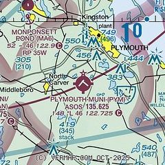
| Sectional chart |
|---|
|
CAUTION: Diagram may not be current

| Airport distance calculator |
|---|
|
|
| Sunrise and sunset |
|---|
|
Times for 05-Feb-2026
| | Local
(UTC-5) | | Zulu
(UTC) |
|---|
| Morning civil twilight | | 06:23 | | 11:23 |
| Sunrise | | 06:52 | | 11:52 |
| Sunset | | 17:02 | | 22:02 |
| Evening civil twilight | | 17:31 | | 22:31 |
|
| Current date and time |
|---|
| Zulu (UTC) | 05-Feb-2026 19:04:56 |
|---|
| Local (UTC-5) | 05-Feb-2026 14:04:56 |
|---|
|
| METAR |
|---|
| KPYM | 051852Z AUTO 29005KT 10SM CLR M01/M12 A2995 RMK AO2 SLP146 T10061117
|
KGHG
12nm N | 051855Z AUTO 30007KT 10SM CLR 01/M12 A2996 RMK AO2
|
KTAN
13nm W | 051852Z AUTO VRB03KT 10SM CLR 00/M12 A2996 RMK AO2 SLP146 T00001117 $
|
KEWB
17nm SW | 051853Z 28006KT 10SM CLR 00/M12 A2996 RMK AO2 SLP144 T00001117
|
KFMH
19nm SE | 051855Z 30005KT 10SM CLR 00/M10 A2997
|
|
| TAF |
|---|
KFMH
19nm SE | 051736Z 0518/0618 33007KT P6SM FEW250 FM060100 01005KT P6SM FEW250 FM060700 02006KT P6SM BKN035 AMD NOT SKED
|
|
| NOTAMs |
|---|
NOTAMs are issued by the DoD/FAA and will open in a separate window not controlled by AirNav.
|
|


