FAA INFORMATION EFFECTIVE 09 JULY 2026
Location
| FAA Identifier: | TAN |
| Lat/Long: | 41-52-26.6890N 071-00-54.8380W
41-52.444817N 071-00.913967W
41.8740803,-71.0152328
(estimated) |
| Elevation: | 41.3 ft. / 12.6 m (surveyed) |
| Variation: | 16W (1985) |
| From city: | 3 miles E of TAUNTON, MA |
| Time zone: | UTC -4 (UTC -5 during Standard Time) |
| Zip code: | 02718 |
Airport Operations
| Airport use: | Open to the public |
| Control tower: | no |
| ARTCC: | BOSTON CENTER |
| FSS: | BRIDGEPORT FLIGHT SERVICE STATION |
| NOTAMs facility: | TAN (NOTAM-D service available) |
| Attendance: | 0600 - 1400 |
| Wind indicator: | lighted |
| Segmented circle: | yes |
| Lights: | ACTVT PAPI RWY 30; REIL RWY 30; MIRL RWY 12/30; WINDSOCK - CTAF. |
| Beacon: | white-green (lighted land airport)
Operates sunset to sunrise. |
Airport Communications
| CTAF/UNICOM: | 122.7 |
| WX ASOS: | 132.675 (508-824-5005) |
| PROVIDENCE APPROACH: | 128.7 |
| PROVIDENCE DEPARTURE: | 128.7 |
| WX AWOS-3PT at 1B9 (11 nm NW): | 118.675 (774-372-2047) |
| WX ASOS at EWB (12 nm S): | 126.85 (508-992-0195) |
| WX ASOS at PYM (13 nm E): | 135.625 (508-319-1421) |
- APCH/DEP SVC PRVDD BY BOSTON ARTCC ON FREQS 124.85/307.9 (WOODSTOCK RCAG) WHEN PROVIDENCE APCH CTL CLSD.
Nearby radio navigation aids
| VOR radial/distance | | VOR name | | Freq | | Var |
|---|
| PVDr078/20.6 | | PROVIDENCE VOR/DME | | 115.60 | | 14W |
| BOSr198/29.0 | | BOSTON VOR/DME | | 112.70 | | 16W |
| MVYr343/33.9 | | MARTHAS VINEYARD VOR/DME | | 114.50 | | 15W |
| PUTr112/37.3 | | PUTNAM VOR/DME | | 117.40 | | 14W |
| NDB name | | Hdg/Dist | | Freq | | Var | | ID |
|---|
| PROVINCETOWN | | 268/37.2 | | 389 | | 16W | | PVC | .--. ...- -.-. |
Airport Services
| Fuel available: | 100LL |
| Parking: | tiedowns |
| Airframe service: | MAJOR |
| Powerplant service: | MAJOR |
| Bottled oxygen: | NONE |
| Bulk oxygen: | NONE |
Runway Information
Runway 12/30
| Dimensions: | 3499 x 75 ft. / 1066 x 23 m |
| Surface: | asphalt, in good condition |
| Weight bearing capacity: | | Single wheel: | 45.0 | | Double wheel: | 73.0 | | Double tandem: | 129.0 |
|
| Runway edge lights: | medium intensity |
| RUNWAY 12 | | RUNWAY 30 |
| Latitude: | 41-52.448128N | | 41-52.273192N |
| Longitude: | 071-01.189010W | | 071-00.454527W |
| Elevation: | 34.9 ft. | | 41.2 ft. |
| Traffic pattern: | left | | left |
| Runway heading: | 124 magnetic, 108 true | | 304 magnetic, 288 true |
| Markings: | nonprecision, in good condition | | nonprecision, in good condition |
| Visual slope indicator: | | | 4-light PAPI on right (4.00 degrees glide path) |
| Runway end identifier lights: | | | yes |
| Touchdown point: | yes, no lights | | yes, no lights |
| Obstructions: | 23 ft. trees, 1000 ft. from runway, 135 ft. right of centerline, 34:1 slope to clear | | 40 ft. trees, 1075 ft. from runway, 125 ft. left of centerline, 20:1 slope to clear |
Runway 4/22
| Dimensions: | 1034 x 60 ft. / 315 x 18 m |
| Surface: | turf/gravel, in fair condition
SFC ROUGH & LOOSE STONES. |
| RUNWAY 4 | | RUNWAY 22 |
| Latitude: | 41-52.653387N | | 41-52.805720N |
| Longitude: | 071-01.276867W | | 071-01.175053W |
| Elevation: | 23.6 ft. | | 25.7 ft. |
| Traffic pattern: | left | | left |
| Runway heading: | 043 magnetic, 027 true | | 223 magnetic, 207 true |
| Touchdown point: | yes, no lights | | yes, no lights |
| Obstructions: | 60 ft. trees, 800 ft. from runway, 125 ft. both sides of centerline, 12:1 slope to clear | | 85 ft. trees, 1000 ft. from runway, 125 ft. left of centerline, 12:1 slope to clear |
Airport Ownership and Management from official FAA records
| Ownership: | Publicly-owned |
| Owner: | CITY OF TAUNTON
CITY HALL, 15 SUMMER ST
TAUNTON, MA 02780
Phone 508-821-1000 |
| Manager: | JAY D' ESPINOSA
4 WESTCOAT
EAST TAUNTON, MA 02718
Phone 508-821-2973 |
Additional Remarks
| A39-12/30 | PCR VALUE: 150/F/B/X/T |
| - | AVOID FLYING OVR THE ELEMENTARY SCHOOL AT DER 30. |
| - | HEL AVOID OVERFLIGHT OF DENSELY POPULATED AREAS W & S OF ARPT. |
| - | CAUTION WILDLIFE, DEER & GEESE ON AND INVOF ARPT AND RWYS. |
| - | FOR CD CTC PROVIDENCE APCH AT 401-738-8945, WHEN APCH CLSD CTC BOSTON ARTCC AT 603-879-6859. |
Instrument Procedures
NOTE: All procedures below are presented as PDF files. If you need a reader for these files, you should download the free Adobe Reader.NOT FOR NAVIGATION. Please procure official charts for flight.
FAA instrument procedures published for use from 09 July 2026 at 0901Z to 06 August 2026 at 0900Z.
STARs - Standard Terminal Arrivals |
|---|
| WIPOR FOUR (RNAV) **NEW** | |
download (284KB) |
IAPs - Instrument Approach Procedures |
|---|
| RNAV (GPS) RWY 12 **CHANGED** | |
download (243KB) |
| RNAV (GPS) RWY 30 **CHANGED** | |
download (245KB) |
| NOTE: Special Alternate Minimums apply | |
download (153KB) |
| NOTE: Special Take-Off Minimums/Departure Procedures apply | |
download (547KB) |
Other nearby airports with instrument procedures:
1B9 - Mansfield Municipal Airport (11 nm NW)
KEWB - New Bedford Regional Airport (12 nm S)
KPYM - Plymouth Municipal Airport (13 nm E)
KOWD - Norwood Memorial Airport (20 nm N)
KGHG - Marshfield Municipal Airport - George Harlow Field (20 nm NE)
|
|

Road maps at:
MapQuest
Bing
Google
| Aerial photo |
|---|
WARNING: Photo may not be current or correct
 Photo taken 12-Jun-2006
as seen approaching from the west
Photo taken 12-Jun-2006
as seen approaching from the west
Do you have a better or more recent aerial photo of Taunton Municipal Airport/King Field that you would like to share? If so, please send us your photo.
|
| Sectional chart |
|---|
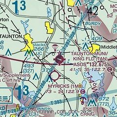
|
| Airport distance calculator |
|---|
|
|
| Sunrise and sunset |
|---|
|
Times for 01-Aug-2026
| | Local
(UTC-4) | | Zulu
(UTC) |
|---|
| Morning civil twilight | | 05:07 | | 09:07 |
| Sunrise | | 05:39 | | 09:39 |
| Sunset | | 20:02 | | 00:02 |
| Evening civil twilight | | 20:33 | | 00:33 |
|
| Current date and time |
|---|
| Zulu (UTC) | 01-Aug-2026 07:17:56 |
|---|
| Local (UTC-4) | 01-Aug-2026 03:17:56 |
|---|
|
| METAR |
|---|
| KTAN | 010652Z AUTO 00000KT 3/4SM BR VV003 17/17 A2992 RMK AO2 SLP132 T01720167
|
KEWB
12nm S | 010653Z AUTO 00000KT 7SM R05/4000V5000FT CLR 18/18 A2992 RMK AO2 SLP131 T01780178
|
KPYM
13nm E | 010652Z AUTO 21003KT 4SM BR FEW002 19/19 A2992 RMK AO2 SLP135 T01940189
|
KOWD
20nm N | 010656Z AUTO 00000KT 1 1/4SM BR SCT003 OVC050 18/18 A2993 RMK AO2 T01830183
|
|
| NOTAMs |
|---|
NOTAMs are issued by the DoD/FAA and will open in a separate window not controlled by AirNav.
|
|

