FAA INFORMATION EFFECTIVE 02 OCTOBER 2025
Location
| FAA Identifier: | 1D4 |
| Lat/Long: | 40-59-33.2030N 081-25-54.4050W
40-59.553383N 081-25.906750W
40.9925564,-81.4317792
(estimated) |
| Elevation: | 1100 ft. / 335 m (estimated) |
| Variation: | 07W (1985) |
| From city: | 5 miles SE of AKRON, OH |
| Time zone: | UTC -4 (UTC -5 during Standard Time) |
| Zip code: | 44685 |
Airport Operations
| Airport use: | Open to the public |
| Activation date: | 10/1961 |
| Control tower: | no |
| ARTCC: | CLEVELAND CENTER |
| FSS: | CLEVELAND FLIGHT SERVICE STATION |
| NOTAMs facility: | CLE (NOTAM-D service available) |
| Attendance: | IREG |
| Segmented circle: | no |
| Landing fee: | yes |
Airport Communications
| CTAF: | 122.9 |
| WX ASOS at AKR (3 nm NW): | 126.825 (330-724-4237) |
| WX ASOS at CAK (5 nm S): | PHONE 330-227-8682 |
| WX AWOS-2 at 1G3 (10 nm N): | 119.15 (330-346-1497) |
| WX AWOS-3 at POV (15 nm NE): | 118.675 (330-298-9353) |
Nearby radio navigation aids
| VOR radial/distance | | VOR name | | Freq | | Var |
|---|
| ACOr240/12.5 | | AKRON VOR/DME | | 114.40 | | 04W |
| BSVr004/15.1 | | BRIGGS VOR/DME | | 114.05 | | 04W |
| CXRr206/33.7 | | CHARDON VOR/DME | | 112.70 | | 05W |
| DJBr129/39.6 | | DRYER VOR/DME | | 113.60 | | 05W |
| NDB name | | Hdg/Dist | | Freq | | Var | | ID |
|---|
| AKRON | | 210/5.0 | | 362 | | 07W | | AK | .- -.- |
Airport Services
| Airframe service: | NONE |
| Powerplant service: | NONE |
| Bottled oxygen: | NONE |
| Bulk oxygen: | NONE |
Runway Information
Runway 9/27
| Dimensions: | 2315 x 110 ft. / 706 x 34 m |
| Surface: | turf, in fair condition
ROLLING TRRN UPSLP TO THE WEST; WEST END 12 FT HYR THAN EAST END. |
| Runway edge markings: | THR & DTHR MRKGS NOT VSB FM 1000 FT AGL; NO BDRY MKRS.
YELLOW TIRES & CONES AT RWY END & DTHR ONLY. |
| RUNWAY 9 | | RUNWAY 27 |
| Latitude: | 40-59.553167N | | 40-59.551667N |
| Longitude: | 081-26.145000W | | 081-25.643333W |
| Elevation: | 1092.0 ft. | | 1100.0 ft. |
| Traffic pattern: | left | | right |
| Displaced threshold: | 180 ft. | | 590 ft. |
| Markings: | , in poor condition | | , in poor condition |
| Obstructions: | 75 ft. trees, 75 ft. right of centerline
OBSTN CLNC SLP 0:1 TO DTHR OVR 75 FT TREES, 0 FT DIST, 75 FT L. | | 65 ft. trees, 100 ft. left of centerline
OBSTN CLNC SLP 0:1 TO DTHR OVR 65 FT TREES, 0 FT DIST, 75 FT R. |
Airport Ownership and Management from official FAA records
| Ownership: | Privately-owned |
| Owner: | REBECCA MAY, TRUSTEE
2571 MYERSVILLE RD
UNIONTOWN, OH 44685-9752
Phone 330-699-3066 |
| Manager: | REBECCA MAY
2571 MYERSVILLE RD
UNIONTOWN, OH 44685-9752
Phone 330-699-3066 |
Additional Remarks
| - | FOR CD CTC CLEVELAND APCH AT 216-352-2323, WHEN APCH CLSD CTC CLEVELAND ARTCC AT 440-774-0223/0490. |
| - | DEER, BIRDS, & WILDLIFE ON & INVOF ARPT. |
| - | OPEN TO THE PUB, WX AND CONDS PMTG. LDG FEES. NO PRKG, FEES MAY APPLY. NO UAS OR SIMILAR ACFT PMTD. |
| - | NO UNAUTH VEHICLES. NO TRESPASSING. |
| - | STUDENT OPS NA; NGT OPS NA. |
Instrument Procedures
There are no published instrument procedures at 1D4.
Some nearby airports with instrument procedures:
KAKR - Akron Fulton International Airport (3 nm NW)
KCAK - Akron-Canton Regional Airport (5 nm S)
1G3 - Kent State University Airport (10 nm N)
3G3 - Wadsworth Municipal Airport (15 nm W)
KPOV - Portage County Airport (15 nm NE)
1G5 - Medina Municipal Airport (17 nm NW)
|
|

Road maps at:
MapQuest
Bing
Google
| Aerial photo |
|---|
WARNING: Photo may not be current or correct
 Photo courtesy of Gil Pataky
Do you have a better or more recent aerial photo of Mayfield Airport that you would like to share? If so, please send us your photo.
|
| Sectional chart |
|---|
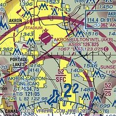
|
| Airport distance calculator |
|---|
|
|
| Sunrise and sunset |
|---|
|
Times for 16-Oct-2025
| | Local
(UTC-4) | | Zulu
(UTC) |
|---|
| Morning civil twilight | | 07:12 | | 11:12 |
| Sunrise | | 07:39 | | 11:39 |
| Sunset | | 18:43 | | 22:43 |
| Evening civil twilight | | 19:11 | | 23:11 |
|
| Current date and time |
|---|
| Zulu (UTC) | 16-Oct-2025 15:58:25 |
|---|
| Local (UTC-4) | 16-Oct-2025 11:58:25 |
|---|
|
| METAR |
|---|
KAKR
3nm NW | 161554Z AUTO 33006KT 10SM CLR 13/01 A3021 RMK AO2 SLP232 T01330006 $
|
KCAK
5nm S | 161551Z 03006KT 10SM CLR 12/03 A3022 RMK AO2 SLP236 T01220028
|
KPOV
15nm NE | 161555Z AUTO 34005KT 10SM CLR 12/03 A3023 RMK AO2 T01230027 PWINO
|
|
| TAF |
|---|
KCAK
5nm S | 161121Z 1612/1712 02007KT P6SM SKC FM170200 VRB03KT P6SM SCT200
|
|
| NOTAMs |
|---|
NOTAMs are issued by the DoD/FAA and will open in a separate window not controlled by AirNav.
|
|


