FAA INFORMATION EFFECTIVE 09 JULY 2026
Location
| FAA Identifier: | 3G3 |
| Lat/Long: | 41-00-11.0200N 081-45-23.4790W
41-00.183667N 081-45.391317W
41.0030611,-81.7565219
(estimated) |
| Elevation: | 973.7 ft. / 296.8 m (surveyed) |
| Variation: | 07W (1990) |
| From city: | 2 miles SW of WADSWORTH, OH |
| Time zone: | UTC -4 (UTC -5 during Standard Time) |
| Zip code: | 44270 |
Airport Operations
| Airport use: | Open to the public |
| Activation date: | 10/1956 |
| Control tower: | no |
| ARTCC: | CLEVELAND CENTER |
| FSS: | CLEVELAND FLIGHT SERVICE STATION |
| NOTAMs facility: | CLE (NOTAM-D service available) |
| Attendance: | CONTINUOUS |
| Wind indicator: | lighted |
| Segmented circle: | no |
| Lights: | ACTVT MIRL RWY 02/20 - CTAF. PAPI RWY 02 & 20 OPR CONSLY. |
| Beacon: | white-green (lighted land airport)
Operates sunset to sunrise. |
Airport Communications
| CTAF/UNICOM: | 122.8 |
| CLEVELAND APPROACH: | 125.5 |
| CLEVELAND DEPARTURE: | 125.5 |
| WX ASOS at BJJ (10 nm SW): | 118.075 (330-669-9105) |
| WX ASOS at AKR (13 nm E): | 126.825 (330-724-4237) |
| WX ASOS at CAK (15 nm E): | PHONE 330-227-8682 |
| WX AWOS-2 at 1G3 (18 nm NE): | 119.15 (330-346-1497) |
- APCH/DEP SVC PRVDD BY CLEVELAND APCH (CLE) 0600-0100. APCH/DEP SVC PRVDD BY CLEVELAND ARTCC (ZOB) ON FREQS 134.9/269.475 (MANSFIELD RCAG) 0100-0600.
Nearby radio navigation aids
| VOR radial/distance | | VOR name | | Freq | | Var |
|---|
| BSVr321/21.6 | | BRIGGS VOR/DME | | 114.05 | | 04W |
| ACOr260/25.9 | | AKRON VOR/DME | | 114.40 | | 04W |
| DJBr144/28.1 | | DRYER VOR/DME | | 113.60 | | 05W |
Airport Services
| Fuel available: | 100LL JET-A JET-A1+
A:JET A ANTI-ICING AVBL AT NOZZLE. |
| Parking: | hangars and tiedowns |
| Airframe service: | MAJOR |
| Powerplant service: | MAJOR |
| Bottled oxygen: | NONE |
| Bulk oxygen: | NONE |
Runway Information
Runway 2/20
| Dimensions: | 3530 x 75 ft. / 1076 x 23 m |
| Surface: | asphalt, in good condition |
| Runway edge lights: | medium intensity |
| RUNWAY 2 | | RUNWAY 20 |
| Latitude: | 40-59.809455N | | 41-00.380950N |
| Longitude: | 081-45.377745W | | 081-45.237328W |
| Elevation: | 965.0 ft. | | 973.6 ft. |
| Traffic pattern: | left | | left |
| Runway heading: | 018 magnetic, 011 true | | 198 magnetic, 191 true |
| Displaced threshold: | 130 ft. | | no |
| Markings: | nonprecision, in fair condition | | nonprecision, in fair condition |
| Visual slope indicator: | 2-light PAPI on left (3.00 degrees glide path) | | 4-light PAPI on left (3.00 degrees glide path) |
| Runway end identifier lights: | no | | no |
| Touchdown point: | yes, no lights | | yes, no lights |
| Obstructions: | 4 ft. fence, 201 ft. from runway, 185 ft. right of centerline
+4 FT FENCE, 200 FT DIST FM THR, 185 FT R, EXTDD TO DTHR, 220 FT R, OBSTN CLNC SLP 0:1. | | 4 ft. fence, 201 ft. from runway, 235 ft. left of centerline
+4 FT FENCE, 200 FT DIST, 235 FT L, EXTDD TO 95 FT DIST, 250 FT L, OBSTN CLNC SLP 0:1. |
Runway 10/28
| Dimensions: | 2155 x 35 ft. / 657 x 11 m |
| Surface: | asphalt, in excellent condition |
| RUNWAY 10 | | RUNWAY 28 |
| Latitude: | 41-00.329175N | | 41-00.327947N |
| Longitude: | 081-45.762803W | | 081-45.294317W |
| Elevation: | 962.8 ft. | | 971.1 ft. |
| Traffic pattern: | left | | left |
| Runway heading: | 097 magnetic, 090 true | | 277 magnetic, 270 true |
| Markings: | basic, in good condition | | basic, in good condition |
| Runway end identifier lights: | no | | no |
| Touchdown point: | yes, no lights | | yes, no lights |
| Obstructions: | 30 ft. pole, 235 ft. from runway, 125 ft. left of centerline, 1:1 slope to clear
+20 FT TWY, 0-185 FT DIST, 100 FT L; +20 FT TWY, 0-85 FT DIST, 110 FT R. | | 26 ft. tree, 655 ft. from runway, 125 ft. both sides of centerline, 17:1 slope to clear |
Airport Ownership and Management from official FAA records
| Ownership: | Publicly-owned |
| Owner: | CITY OF WADSWORTH ARPT COMMISSION
WADSWORTH MUNICIPAL BLDG, 120 MAPLE ST
WADSWORTH, OH 44281-1825
Phone 330-335-1521 |
| Manager: | QUIENTON REID
840 AIRPORT DR
WADSWORTH, OH 44281-9552
Phone 330-334-9861
OR 330-241-2562. |
Additional Remarks
| - | CAUTION: EXTSV HEL OPS. |
| - | RWY 02 TFC PAT PREFERRED ENTRY AT 45 DEGS TO UPWIND LEG TO AVOID TFC AT 15G ARPT 2.5 NM NW. |
| - | RWY 10 CLSD FOR DEPARTURE WHEN WIND LESS THAN 15 KTS FM THE EAST. |
| - | NO LINE OF SIGHT BTN RWY'S 02 & 10. |
| - | RWY 20 CALM WIND RWY BLO 4 KTS FOR NOISE ABATEMENT. AVOID HOSPITAL TO THE N. |
| - | FOR CD CTC CLEVELAND APCH AT 216-352-2323, WHEN APCH CLSD CTC CLEVELAND ARTCC AT 440-774-0223. |
| - | TWY B CLSD TO PWRD ACFT |
| - | BIRDS, DEER, & OTR WILDLIFE ON & INVOF ARPT. |
| - | CAUTION: GLIDER OPS ALL RWY'S |
Instrument Procedures
NOTE: All procedures below are presented as PDF files. If you need a reader for these files, you should download the free Adobe Reader.NOT FOR NAVIGATION. Please procure official charts for flight.
FAA instrument procedures published for use from 09 July 2026 at 0901Z to 06 August 2026 at 0900Z.
IAPs - Instrument Approach Procedures |
|---|
| RNAV (GPS) RWY 02 | |
download (207KB) |
| RNAV (GPS) RWY 20 | |
download (210KB) |
| NOTE: Special Take-Off Minimums/Departure Procedures apply **CHANGED** | |
download (515KB) |
Other nearby airports with instrument procedures:
1G5 - Medina Municipal Airport (8 nm N)
KBJJ - Wayne County Airport (10 nm SW)
KAKR - Akron Fulton International Airport (13 nm E)
KCAK - Akron-Canton Regional Airport (15 nm E)
1G3 - Kent State University Airport (18 nm NE)
|
|

Road maps at:
MapQuest
Bing
Google
| Aerial photo |
|---|
WARNING: Photo may not be current or correct

Do you have a better or more recent aerial photo of Wadsworth Municipal Airport that you would like to share? If so, please send us your photo.
|
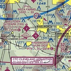
| Sectional chart |
|---|
|
CAUTION: Diagram may not be current

| Airport distance calculator |
|---|
|
|
| Sunrise and sunset |
|---|
|
Times for 19-Jul-2026
| | Local
(UTC-4) | | Zulu
(UTC) |
|---|
| Morning civil twilight | | 05:40 | | 09:40 |
| Sunrise | | 06:12 | | 10:12 |
| Sunset | | 20:55 | | 00:55 |
| Evening civil twilight | | 21:27 | | 01:27 |
|
| Current date and time |
|---|
| Zulu (UTC) | 20-Jul-2026 02:14:04 |
|---|
| Local (UTC-4) | 19-Jul-2026 22:14:04 |
|---|
|
| METAR |
|---|
KBJJ
10nm SW | 200156Z AUTO 00000KT 7SM CLR 16/13 A3003 RMK AO2 SLP166 T01560133
|
KAKR
13nm E | 200154Z AUTO 00000KT 7SM CLR 18/12 A3001 RMK AO2 SLP158 T01830122 $
|
KCAK
15nm E | 200151Z 01004KT 6SM FU CLR 19/10 A3002 RMK AO2 SLP159 T01940100 $
|
|
| TAF |
|---|
KCAK
15nm E | 191720Z 1918/2018 01007KT 6SM HZ FEW250 FM200100 VRB03KT 6SM HZ SCT250
|
|
| NOTAMs |
|---|
NOTAMs are issued by the DoD/FAA and will open in a separate window not controlled by AirNav.
|
|


